2021:079 - TEMPLERAINY, Arklow, Wicklow
County: Wicklow
Site name: TEMPLERAINY, Arklow
Sites and Monuments Record No.: N/A
Licence number: 21E0307
Author: András Hindli
Author/Organisation Address: Burnside, St. Oran's road, Buncrana, Co. Donegal
Site type: Excavation - miscellaneous
Period/Dating: Prehistoric (12700 BC-AD 400)
ITM: E 724589m, N 676518m
Latitude, Longitude (decimal degrees): 52.825207, -6.151300
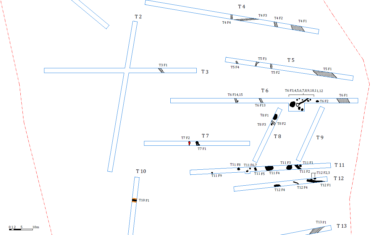
A total of sixteen trenches were excavated in a field of a proposed solar-farm site at Templerainy townland, Arklow, Co. Wicklow, most of them targeting geophysical results (licence 21R0023). The testing programme confirmed a high concentration of potential archaeological features at the north-eastern portion of the site, in relatively close proximity to the bend of the stream that bounds the field to the east.
Over 35 potential archaeological features were identified, many concentrated in Trenches T6, T11 and T12. Trench T6, especially within the eastern half, revealed fifteen potential features: possible post-holes, several pit-like features, a hearth and a narrow but slightly irregular linear (possibly structural) feature, filled by a charcoal-rich deposit. An extension to the trench was applied to determine the extent and nature of this feature showing that it stops at a large, relatively flat stone. The stone appears to be delimited by small vertical stones, however, it was not possible to confirm its archaeological nature. T11 contained nine potential archaeological features, including possible post-holes, pit-like features, a possible kiln, linear feature and several hearths. Trench T12 contained five potential archaeological features. A linear feature with a sub-rounded terminus, running east–west, was identified at the eastern end of the trench. This feature is likely associated with the linear feature spotted in Trench T11. A quadrant section revealed that this was a ditch-like feature, approximately 0.4m in depth. Two sub-circular features, both rich in charcoal and a faint narrow curvilinear feature were also identified at the eastern end of Trench T12.
Trenches T4, T5 and T7 also contained several potential features. T7 revealed burning activity (hearth) and a possible figure-of-eight-shaped kiln. Further investigation confirmed this feature as being a kiln and a flint blade (55mm x 20mm x 5mm) was found within its fill. Trenches T4 and T5 contained several linear features, one of them being a terminus, however, the archaeological nature of these could not be confirmed. A 5–6m wide linear feature (also identified on the geophysical survey) was spotted running north–south and slightly turning north-west/south-east through the eastern end of Trenches T4, T5 and T6. Two quadrants excavated into this feature revealed that it had a gradual break of slope and was only approximately 0.3m in depth. It was orientated towards the stream, indicating that it could be some sort of drainage system or a mill race.
Trenches T2 and T3 were targeting the location of the possible curvilinear feature spotted on a 1995 aerial photograph. Only one linear feature was identified in Trench T3 (also depicted on the geophysical survey). Further investigation revealed that it was likely an agricultural feature, possibly associated with land drainage. No other potential archaeological features were found at the north-western corner of the field.
Trenches T10, T13, T14, T15 and T16, were targeting the southern half of the subject field (most of which was not covered by the geophysics survey). Traces of deep ploughing and furrows were spotted within all the trenches. At the northern end of Trench T10 a post-medieval brick lane/wall was found (marked on the geophysics results as ‘former field division’), running east–west. This seems to be connecting to the stream ford/cross and lane to the east depicted on the historic maps.
The multiple linear features recorded within the trenches at the north-eastern corner of the field might be the result of post-medieval agricultural activity. However, the examples investigated did not present the characteristics of agricultural furrows and, given the concentration of other more likely archaeological features in the vicinity, should not be dismissed as non-archaeological.