2021:157 - ROSSPILE SOLAR FARM DEVELOPMENT, Wexford
County: Wexford
Site name: ROSSPILE SOLAR FARM DEVELOPMENT
Sites and Monuments Record No.: WX040-095 & WX040-087
Licence number: 21E0014
Author: Padraig Dunne, John Cronin & Associates
Author/Organisation Address: 3A Westpoint Trade Centre, Ballincollig, Co. Cork
Site type: Excavation - miscellaneous
Period/Dating: Multi-period
ITM: E 685888m, N 618463m
Latitude, Longitude (decimal degrees): 52.311083, -6.740410
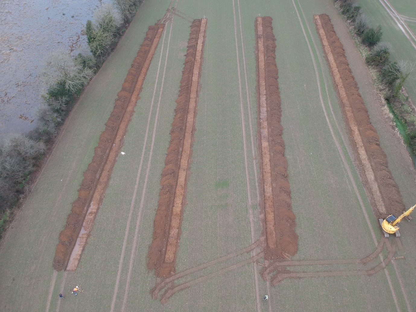
The archaeological test trenching investigations were undertaken in greenfield locations within Rosspile Solar Farm Development. The investigations comprised targeted test trenching on foot of a geophysical survey undertaken in October 2020 (Licence 20R0129). In addition to this, the proposed construction compounds, internal trackways and inverters were also targeted. A total of 147 (1.8m wide) test trenches were excavated and examined, comprising 7,930 linear meters (equivalent to 14,288.4m²) of the solar farm footprint. The excavated spoil from all trenches was also systemically inspected and scanned with a metal detector to assist with artefact retrieval (Detection Device Licence ref. 21R003). In total, over 245 potential archaeological features were identified including eight potential prehistoric structures, numerous potential structural ditches, four potential limekilns, three potential keyhole-shaped kilns, one potential pottery kiln, four fulachta fiadh/burnt mounds, five potential barrows and two prehistoric enclosures as well numerous potential pits, post-holes, stake-holes and hearths. These identified archaeological features have been categorized into 34 distinct archaeological sites within the three townlands of Raheenduff, Rosspile and Coolcliffe.
The potential sites are summarized as:
• An enclosed settlement site of three potential structures with peripheral pits/post-hole and hearths in Field GEO 1.3 (Raheenduff 01-04)
• Two limekilns and two possible structures within Field GEO 1.2 (Raheenduff 05-07)
• A potential late medieval farm settlement site with peripheral activity to the south-east, and a fulacht fiadh/burnt mound to the west of Field GE 1.1 (Raheenduff 08-10)
• A Bronze Age barrow and associated peripheral settlement at the centre and south-eastern portions of Field GEO 2.2 and a keyhole-shaped kiln to the north-west (Rosspile 01-03)
• Peripheral settlement activity at the Rosspile substation Field (Rosspile 04)
• A potential keyhole-shaped kiln in Field GEO 3.1 and a fulacht fiadh/burnt mound and limekiln in Field GEO 3.2 (Rosspile 05-07)
• Late medieval field systems and settlement activity in Field GEO 3.3 and a fulacht fiadh/burnt mound in Field GE0 3.6 (Rosspile 08-09)
• A prehistoric enclosure with an internal structure, and a limekiln in Field GEO 3.7 (Rosspile 10-11)
• Two structures, four potential barrows, one potential ceremonial enclosure and peripheral settlement activity in Field GE0 4.1 (Coolcliffe 01-09)
• Multi-period settlement site in Field GEO 4.2 (Coolcliffe 10) and a fulacht fiadh/burnt mound, limekiln, and post-medieval settlement related to Coolcliffe house in Field GE0 4.3 (Coolcliffe 11-13)
In addition to the above, several archaeological artefacts were recovered during the programme of test trenching. These comprised of five fragments of flint debitage from the surface deposit of potential pits in sites Coolcliffe 1 and Coolcliffe 05 in Field GEO 4.1. Likewise, 12 sherds of Bronze Age funerary pottery were recovered, eight from a cremation pit within Rosspile 02, two from a cremation pit in Coolcliffe 06, and one each from cremation pits in Coolcliffe 04, and from the topsoil of Trench 121. Four sherds of potential late medieval Leinster cooking ware pottery were also uncovered from a possible pottery kiln in Coolcliffe 10 in Field GEO 4.2.