2021:357 - WATERFORD: Bishop's Palace Garden, Waterford
County: Waterford
Site name: WATERFORD: Bishop's Palace Garden
Sites and Monuments Record No.: WA009-005
Licence number: 21E0115
Author: Orla Scully
Author/Organisation Address: 7 Bayview Tramore X91 X462
Site type: Town
Period/Dating: Modern (AD 1750-AD 2000)
ITM: E 660902m, N 612360m
Latitude, Longitude (decimal degrees): 52.259572, -7.107887
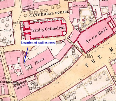
Archaeological monitoring was carried out during excavation of a pit within a circular flower bed in the gardens to the west of the Bishop’s Palace. The pit was dug to allow for a base to be inserted to support a granite memorial to the eleven men from Waterford who fought in the Spanish Civil War; the base which extended north-south at the western side of the circular flower bed. A stone wall was exposed at a depth of 0.32m and it reached a depth of 0.93m beneath the modern surface. At a depth of 0.5m a layer of post-medieval garden soil abutted the wall. The maximum length exposed was 1.9m north-south. The widest point exposed was 0.65m. The western extent of the wall was not exposed, as the excavation was confined to the limits of the circular garden feature. It was located 8.2m west of and parallel to the west wall of the Bishop’s Palace. The wall did not appear to have a wall trench at its eastern side, indicating the soil accumulated against it, or that it had been built against the layer from the other side. A lead pipe was seen to run north-south near the base of the wall, the excavation for which may have destroyed information in this regard. There were elements of red brick in the wall, one on the surface, and another nearer the base. Earlier maps indicate the area as open, with the first appearance of a building in the area on the 1842 1st ed O.S. The wall was wrapped in foam and left in situ.