2021:780 - N74, Ballyhusty Realignment Scheme, Garranacanty 2, Tipperary
County: Tipperary
Site name: N74, Ballyhusty Realignment Scheme, Garranacanty 2
Sites and Monuments Record No.: N/A
Licence number: 21E0833 and 21R0323
Author: Kate Taylor, TVAS (Ireland) Ltd
Author/Organisation Address: Ahish, Ballinruan, Crusheen, Co. Clare
Site type: Structure and Bridge
Period/Dating: Modern (AD 1750-AD 2000)
ITM: E 591776m, N 636520m
Latitude, Longitude (decimal degrees): 52.480040, -8.121068
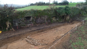
Garranacanty 2 was located on the proposed N74 Ballyhusty Realignment Scheme, near Tipperary town, Co. Tipperary. The site was situated in a pasture field on the north side of the current N74.
The excavation, which was carried out on behalf of Tipperary County Council/Transport Infrastructure Ireland, revealed a stone-lined drain and also examined part of a revetment wall against the embankment supporting the N74 road and a portion of a nearby early modern bridge. No artefacts were recovered during the excavation or through metal detection. Samples of mortar from the revetment wall and bridge were taken for analysis.
Analysis is not yet complete, however it is hoped that it may be possible to determine whether the wall and bridge were constructed using the same mortar and therefore whether they could be of a similar date.

