2021:297 - CASHEL: Spafield, Green, Wallers Lot, Spafield, Owens & Biggs Lot, Tipperary
County: Tipperary
Site name: CASHEL: Spafield, Green, Wallers Lot, Spafield, Owens & Biggs Lot
Sites and Monuments Record No.: TS061-071001
Licence number: 21E0596
Author: Niall Gregory
Author/Organisation Address: Dunburbeg, Clonmel Road, Cashel, Co. Tipperary
Site type: Town
Period/Dating: Modern (AD 1750-AD 2000)
ITM: E 607755m, N 639696m
Latitude, Longitude (decimal degrees): 52.508594, -7.885762
The client, Tipperary County Council, undertook remedial upgrading and surface works at the Green and Old Road Cashel, Co. Tipperary (Townlands of Green, Waller’s-Lot, Spafield, Owen’s and Bigg’s-Lot). The upgrading works entailed excavation and installation of drains on the Green and electricity ducting and light stands on the Old Road. As this work was situated in zones of archaeological potential associated with southern extent of Cashel’s medieval town (TS061-025) and the Old Road being of some antiquity (TS061-071001), an archaeological licence was applied for to archaeologically monitor the ground works.
The location of the works extended from Irish Trans Metric 607715 638804 at north to 607844 640366 at south. The ground works and monitoring commenced on 23 August and took place on a phased basis until completion on 24 November 2021.
The footpath replacement on both the Green and Old Road entailed removal of existing concrete path surface and excavation to depth of up to 0.25m for the path and 0.3m for the kerbing. Paths including kerbs were between 1.8m and 2.2m in width. Box trench excavation occurred to reset the kerbing in line with how it was previously situated. In all instances either the underlying bedding of stone chips was exposed, or at shallower deposits of modern materials, the underlying natural subsoil was exposed. Nothing of archaeological of historical nature was revealed.
Drainage trench excavation occurred at the Green, going on to Feehan’s Road. This was typically run along the edge of the path on the roadside and across the road at key locations to connect between existing drainage ducts. Box trench excavation was for the most part up to 0.4m in depth and 0.3m in width. Where new sections of drainage duct was installed, the stratigraphy consisted of 0.1m to 0.2m tarmac; onto 0.15m to 0.2m stone chip bedding; onto natural subsoil that varied from orange silty sand to yellow silty clay with decayed and undecayed limestone inclusions. Where the line of the drainage duct was replacement of an existing section, the stratigraphy retaining the duct consisted of sands or lemix beneath the tarmac’s stone bedding.
Deeper trench excavation occurred at two points crossing Feehan’s Road and the Green from the Upper Green at south and across the road to north side. These trenches were typically 1m in depth and 0.5m to 0.6m in width. However, the westernmost trench was excavated to the depth of 1.6m and 1m in width. This was to overcome blockages in the pre-existing ducts. At these locations that stratigraphy was 0.15m to 0.2m tarmac; onto 0.15m stone bedding; onto natural subsoil. Where the trench truncated or followed pre-existing services, the subsoil was replaced with sand or lemix.
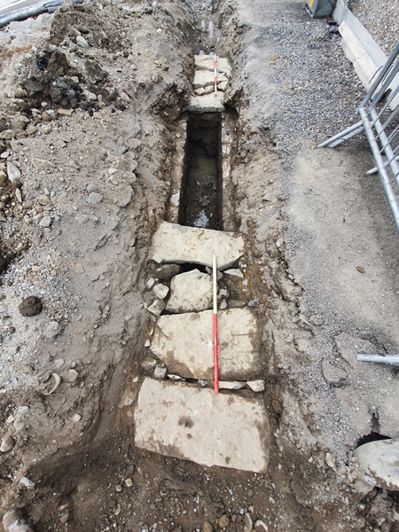
A previous 19th-century culverted water channel was found immediately to the east side of the junction of the Green with Feehan’s road and on the north side of Feehan’s Road. It first appeared as the largely disturbed remains of what initially appeared to be a small culverted drain. This consisted of an east to west and north to south junction stone-lined culverted box drain at ITM 607804 640357. I measured of 0.23m in height and a 0.17m wide drain set in a 0.36m wide and 0.3m high box trench cut into natural subsoil. The single course was 0.1m average width and 0.2m average height, stone-lining sides of the box trench and capped with a single course and a single span flat limestone of c. 0.12m thickness. It was either truncated to south or perhaps reached its southern point here and then continued to west beneath the street surface as evidenced by stones continuing in that direction, albeit as a collapsed culvert. The culvert continued to north past the extent of the works and was truncated by electricity ducts to east. The ducts and sand bedding continued to east for 1.3m, after which a large, culverted channel was uncovered that had been disturbed and partially destroyed by later works. This consisted of 5.6m east to west culverted channel with capstones revealed 0.3m beneath ground level. The exposed portions of the capstones were up to 0.6m wide, 0.15m thick and 11.18m long set traversing the culvert. The culvert is lined on both sides with c. 0.2m long, 0.12m wide and 0.1m thick lime mortar-bonded stone for height of 0.9m as five courses to base of compact stony grey marl natural subsoil.
The electricity duct and light stand excavation works took place on the Old Road, from east of Minogue Furniture Store in a northern direction along the west side of the road and terminated at the entrance to Cashel Rugby Club. This consisted of entirely removing and replacing the concrete path (where it existed) up to the kerb line, after which a box trench was excavated to retain the electricity duct. This meant that c.1.6m of concrete footpath was replaced. The exposed underlying stratigraphy consisted of stone chip bedding. The 0.25m to 0.3m wide box trench was 0.3m in average depth and was excavated directly into either modern stone bedding or natural subsoil. Nothing of archaeological or historical value was encountered. Where the excavated surface consisted of tarmac, it was found that the box trench stratigraphy comprised 0.12m to 0.18m tarmac; onto 0.1m to 0.15m stone bedding; onto natural subsoil. However, the stratigraphy of the northernmost 60m of the trench that terminated at the rugby club entrance, retained topsoil beneath the stone chip beading for the entirety of the remaining depth of the trench. Nothing of archaeological or historical value was encountered.
No archaeology was encountered during the works.