2021:201 - KNOCKNASHEE, Sligo
County: Sligo
Site name: KNOCKNASHEE
Sites and Monuments Record No.: SL032-013001
Licence number: 20E0415
Author: Dirk Brandherm
Author/Organisation Address: School of Natural and Built Environment, Queen's University Belfast, BT7 1NN
Site type: Hillfort
Period/Dating: Multi-period
ITM: E 555768m, N 818909m
Latitude, Longitude (decimal degrees): 54.117331, -8.676548
For two weeks in August 2021 an excavation was carried out on the eastern edge of the summit plateau of Knocknashee hill, on the perimeter of the Knocknashee Archaeological Complex (SL032-013—), by a team comprising mostly local volunteers, organized by the Archonry Mullinabreena Community Enhancement Group and led by archaeologists from Queen’s University Belfast. Funding for the excavation was generously made available by Sligo County Council through its Community and Voluntary Grant Scheme.
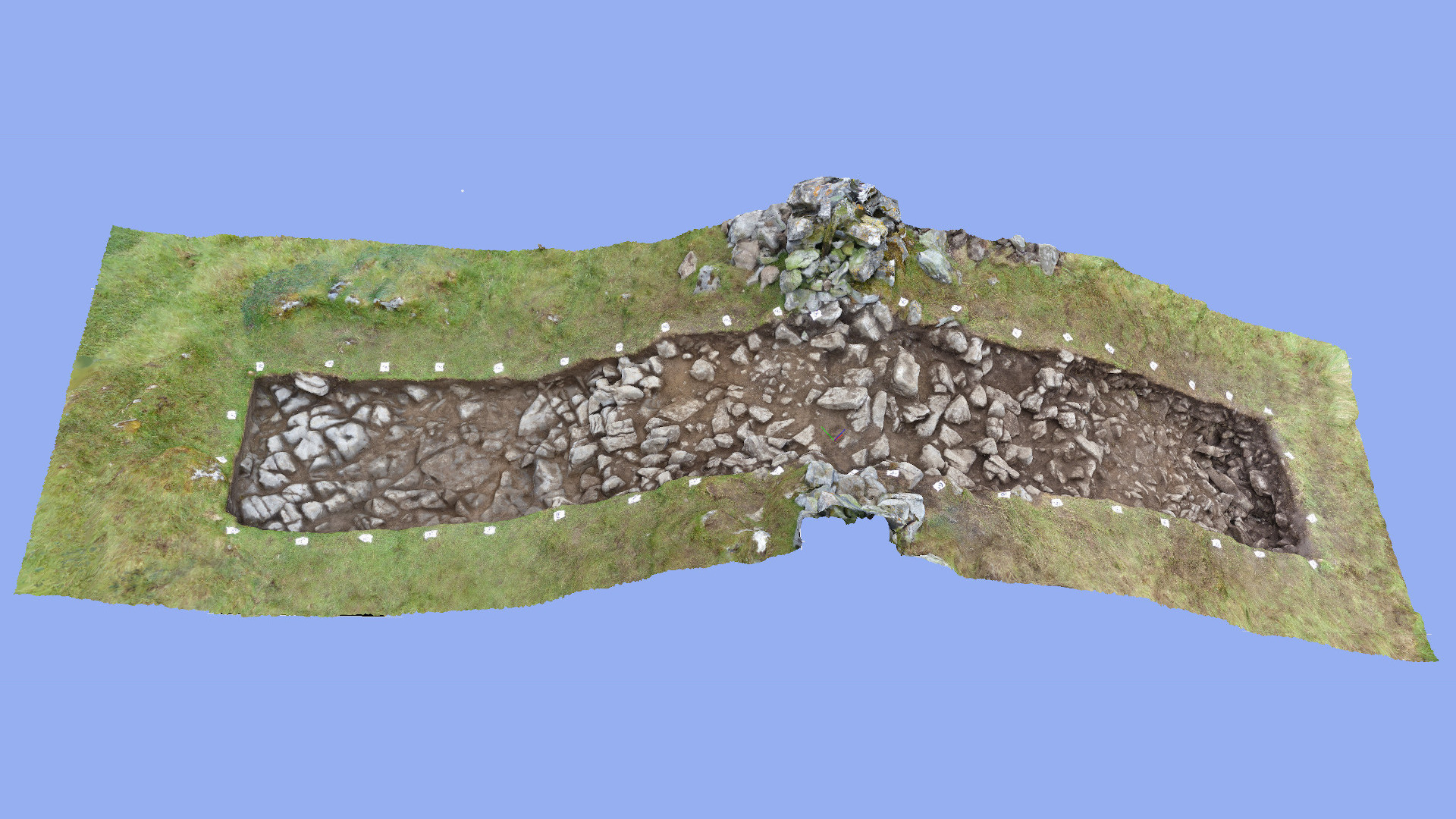
Following up on the results from the 2020 campaign, which had called into question both the prehistoric date and the defensive nature of the system of perimeter banks enclosing much of the summit plateau, the excavation aimed to investigate what appeared to be a more substantially preserved section of the inner bank, approximately 200m to the south of the trench excavated the previous year, in order to obtain additional evidence regarding the date and the nature of that inner bank.
The excavation consisted of opening a 1.5m wide and 10m long trench across the inner main perimeter bank. The modern dry stone wall defining the townland boundary of Knocknashee Common that sat on top of the bank had to be dismantled before a cut could be executed through the bank. Unlike in the campaign of the previous year, which had established that the dry stone wall in the then excavated section protruded through the ‘bank’ and sat directly on decayed limestone bedrock, revealing that what had hitherto been perceived as an earthen bank really constituted tumble from the dry stone wall on which turf had developed, this year’s excavation found the dry stone wall sitting on what was indeed a bank-like feature composed of boulder clay. However, no evidence was found to suggest that this bank-like feature qualifies as a man-made structure. Rather, the results from the excavation seem to indicate that we are dealing with a natural feature, whose bank-like appearance might have been enhanced by the removal of building material for the dry stone wall from a strip of boulder clay running in parallel with that wall on the inside of the ‘bank’. The boulder clay composing the ‘bank’ is contiguous with the boulder clay of the geological subsoil and is not separated from it by any buried topsoil layer, as one would expect if this was indeed a man-made feature. A sondage excavated into the body of the ‘bank’ also did not reveal any trace of layering indicating the presence of dumped material. The discovery during the excavation of some isolated prehistoric chert implements at the interface between boulder clay and topsoil does not contradict this interpretation.
In conclusion, the findings from this excavation cast further doubt on the interpretation of the site as a Bronze Age hillfort (cf. Condit et al. 1991; Egan et al. 2005). While a Late Bronze Age date for some of the roundhouse occupation of the plateau has been firmly established by previous work (Brandherm et al. 2020), that Late Bronze Age occupation does not seem to have been enclosed by any kind of man-made structure visible in the archaeological record.
References
Brandherm, D.; McSparron, C. and Boutoille, L. 2020. Excavation of Late Bronze Age roundhouses at Knocknashee, Co. Sligo: preliminary results from the 2017 campaign. Emania 25, 155–164.
Condit, T; Gibbons, M. and Timoney, M. 1991. Hillforts in Sligo and Leitrim. Emania 9, 59-62.
Egan, U.; Byrne, E. and Sleeman, M. 2005 Archaeological Inventory of County Sligo, Vol. 1: South Sligo, comprising the Baronies of Corran, Coolavin, Leyny and Tirerrill. Dublin, Stationery Office.