2021:537 - BEY MORE, Meath
County: Meath
Site name: BEY MORE
Sites and Monuments Record No.: ME020-093
Licence number: 19E0405
Author: Geraldine Stout and Matthew Stout
Author/Organisation Address: Chapel Road, Julianstown, Co. Meath, A92 V6W8
Site type: Enclosure
Period/Dating: Medieval (AD 400-AD 1600)
ITM: E 709530m, N 772877m
Latitude, Longitude (decimal degrees): 53.694103, -6.341483
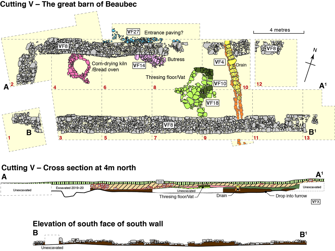
The third season of excavations at Bey More, Co Meath were concentrated to the west of the upstanding remains in an area where structures had been identified in the geophysical survey and in two previous excavation seasons in July 2019 and July 2020. Four main phases of activity were discovered, prehistoric activity, medieval cultivation, a medieval barn and a post-medieval avenue.
The foundations of an impressive rectangular, undivided, stone building, were uncovered at a depth of 0.22–0.35m below the sod. This is thought to be a great medieval barn. It is located immediately west of the upstanding remains and runs on an east-west axis (L 23.8m, Wth 7.5m). It has an entrance almost midway along the north wall. The corners of the building have been robbed out, and its eastern end is poorly preserved.
The walls (VF8) vary in width from 1.28m in the south, where they are better preserved, to 1m in the north. They survive to a maximum of three courses, varying in height from 0.22m to 0.45m of regularly coursed masonry, using rough limestone blocks (average size 0.43m by 0.12m) with flat packing stones in-between. The walls are stone-faced with a rubble core. There is no evidence for a footing. In the south-west corner there is a secondary buttress (L 1.77m, H 1.79m) running at a right angle from robbed wall face into the southern limit of excavation. There is a greywacke slab up against the north-west corner. The north wall has a slight incline outwards, the west wall overlies a cultivation furrow and the south wall has a large cavity in its east end. The east side of the wall was only partially excavated. There are regularly spaced depressions in the south wall that show where the timbers for a cruck roof were set (Niall Brady, pers. comm.)
Inside the building were the remains of a kiln, a flagged area (VF18) with stone setting (VF10) thought to be the foundations of a brewing vat, and a lintelled drain (VF4) which runs across the interior of the building and through the foundation course of the north and south barn walls. Outside the barn wall along the south side was a shallow dark loamy soil containing shells and bones, which is medieval waste (VF11/VF16).