2021:598 - DONACARNEY GREAT (2), Donacarney Great, Bettystown, Meath
County: Meath
Site name: DONACARNEY GREAT (2), Donacarney Great, Bettystown
Sites and Monuments Record No.: ME021-029
Licence number: 19E0077
Author: Antoine Giacometti, Archaeology Plan
Author/Organisation Address: 32 Fitzwilliam Place Dublin 2
Site type: Burial ground and Ring-ditch
Period/Dating: Multi-period
ITM: E 714548m, N 773940m
Latitude, Longitude (decimal degrees): 53.702576, -6.265145
Archaeological excavations at a site at Donacarney Great, Bettystown, Co. Meath from 2019 to 2021 uncovered a fascinating series of cemeteries dating from the prehistoric period to the seventh century AD. The site was excavated by Níall Garahy (2019:616) and Antoine Giacometti (2021 season) and was situated at Whitefield Hall, Bettystown, Co. Meath in the townland of Donacarney Great (extending into the townland of Bethaghstown to the north). This archaeological site has been named Donacarney Great 2 to distinguish it from an archaeological site 400m to the north, also in Donacarney Great townland, excavated ten years earlier (Giacometti 2010:517).
Post-excavation work, including analysis of the burials and radiocarbon dating, is ongoing, so this presents only the preliminary results.
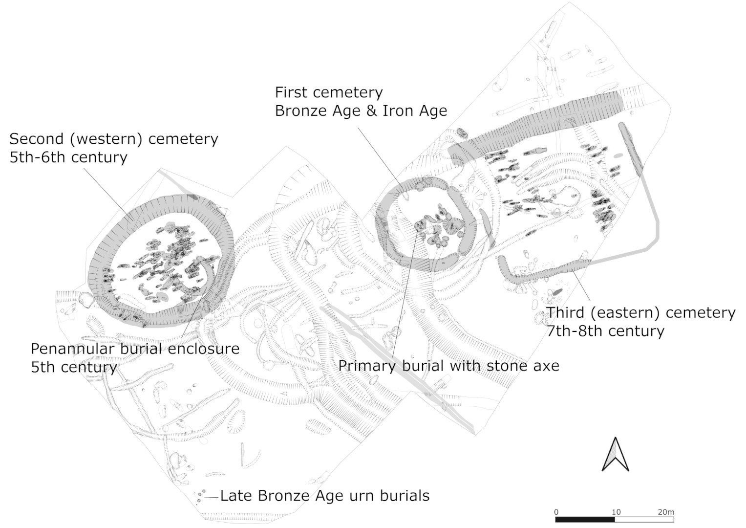
What makes Donacarney Great 2 such a significant archaeological site is the series of spatially and chronologically distinct cemeteries dating from the prehistoric period to the first half of the early medieval period. The earliest cemetery was located in the centre of the site, and appears to have been established around a single very deep crouched inhumation buried with a stone axe in its hand, preliminary dated late Neolithic or Early Bronze Age. That cemetery continued in use during the Bronze Age and into the Iron Age, when a segmented ring ditch was cut around it and fourteen crouched burials preliminarily dated to the Late Iron Age were interred.
A small penannular enclosure to the west marked the establishment of a second burial ground, which was extended over the fifth and sixth centuries into a cemetery of over a hundred individuals. A third burial location in the east was established by the seventh century, at which point it appears that the second cemetery was no longer used. The shift in the focus eastwards may reflect a growing consensus, as Christianity became consolidated in Ireland, for the appropriate location for burial. An unusual south-east-facing structure, perhaps associated with rituals for the dead, seems to have been constructed next to the western cemetery at the same time as the shift from west to east, and may have provided a focal point for ritualised movement through the complex linking the three cemeteries.
Over the course of the fifth to eight centuries, the three cemeteries were gradually fused together, culminating in a polyfocal ceremonial centre. This was defined by an architecture of non-circular enclosures connected by bridges that channelled movement along defined routes. As with similar sites (‘cemetery settlements’) the cemetery complex had no evidence for residential domicile within the enclosed spaces. It did, however, and again in common with similar sites, have evidence for extensive agrarian and industrial processing that at Donacarney Great probably reflects trade and tribute. This, and the large and varied assemblage of imported pottery, links the cemetery complex to the wider political landscape during the time before the Southern Uí Néill gained full control over Brega.

