2021:551 - DUNSANY: L2208 Dunsany Road drainage works, Meath
County: Meath
Site name: DUNSANY: L2208 Dunsany Road drainage works
Sites and Monuments Record No.: ME037-017, ME037-044
Licence number: Unlicensed
Author: Niall Roycroft
Author/Organisation Address: c/o Meath County Council
Site type: Cross -wayside cross and Gate lodge
Period/Dating: Multi-period
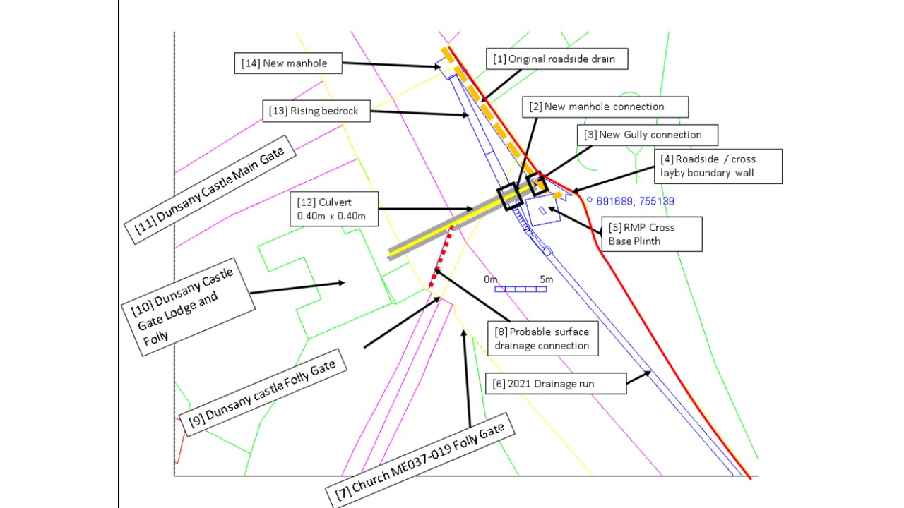
ITM: E 691687m, N 755139m
Latitude, Longitude (decimal degrees): 53.538183, -6.616789
Meath County Council is proposing to replace a blocked drainage run alongside the Kilmessen to Dunsany Road L2208 over approx. 140m to either side of Wayside Cross ME037-017 and Bullaun (cupped) Stone ME037-044. The Cross is thought to date to c.1600 and it sits on top of a square, stone plinth of three steps of which the top step includes the reused Bullaun Stone. The structure sits on the edge of the present road in a walled niche opposite the gates to Dunsany Castle.
Dunsany Castle Demesne is an Architectural Conservation Area (ACA) including buildings on the Record of Protected Structures of MH037-304 to 309/NIAH 14403711-14 and 14403703. Although the Cross does not lie within the ACA, the roadside boundary (a stone-faced bank) generally matches the Dunsany ACA demesne wall.
In November 2020, the National Monuments Service were notified of the intention to relay a blocked stone-built roadside drain that currently passes along the east side of the L2208 and passes to the rear (east) side of Cross ME037-017 between the three step base plinth of the cross and the walled roadside boundary. The new drainage run 140m long by 0.65-0.85m wide x 0.85m deep would generally follow and replace the line of the old stone culvert, but instead of swerving to the east side of the Cross base, would continue in a direct line past the west side of the base. Works were monitored on 19 March and 22 March 2021.
Results
Natural bedrock was seen in occasional areas from 0.55m below present ground level (PGL) to below the base of the trench at 0.8m below PGL. The top of the bedrock was shattered. Above this was a mid-yellow brown silty clay glacial till. The trench did not expose any construction cut for the Dunsany Cross. To the south of the Cross base a piece of buried masonry bonded with light grey mortar was exposed 1.5–3m on the west side of the trench. This masonry had a terminus and ran into a backfilled construction cut that ran down the middle of the new trench. At the north-west point of the Cross Base a second piece of masonry 1m wide turned into an east-west stone-built culvert (internally 0.4m x 0.4m) that fed drainage from the Dunsany Castle Gate Lodge area and the L2208 west side surface drainage under the L2208 and into the original stone-built drain along the east side of the L2208. All the masonry and drainage culverts probably go with the Dunsany Castle Gate Lodge area construction (NIAH 14403703) c.1840.
The culvert was sealed with a gravel road surface 0.17m which was capped with a 30mm layer of tarmac, then a 70mm layer of lean mix and then another 30mm layer of tarmac (current road surface).