2021:549 - KELLS: Carrick and Maudlin Street Revival, Meath
County: Meath
Site name: KELLS: Carrick and Maudlin Street Revival
Sites and Monuments Record No.: ME017-044, ME017-044004
Licence number: C001009; E005240
Author: Niall Roycroft
Author/Organisation Address: c/o Meath County Council
Site type: Town defences and Historic town
Period/Dating: Multi-period
ITM: E 674089m, N 776115m
Latitude, Longitude (decimal degrees): 53.729423, -6.877221
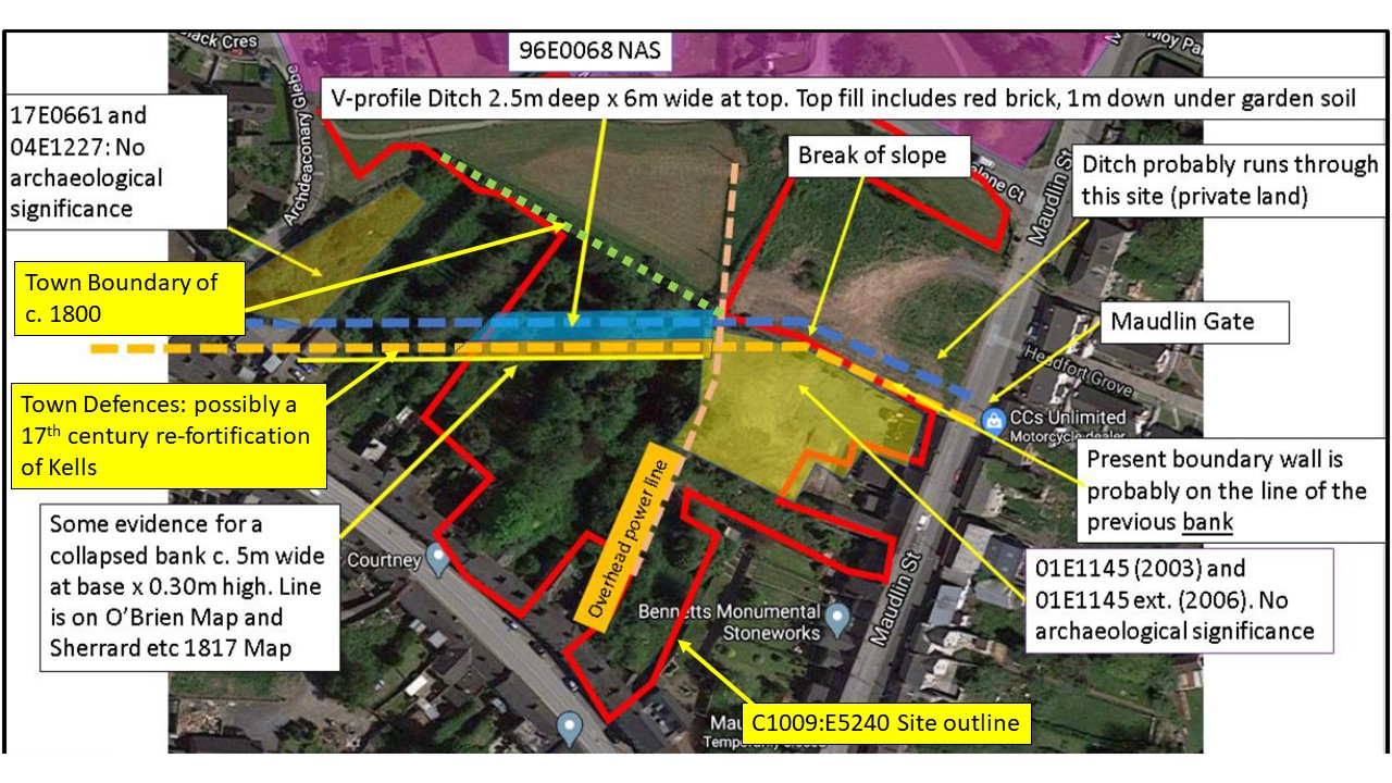
Preliminary archaeological Monitoring and Test Trenching took place at the proposed Carrick and Maudlin Street Revival project in Kells, Co. Meath. The site is approximately 1.46 ha and this includes the area previously tested under 01E1145 (2003) and 01E1145 ext. (2006) which is approx. 1630 sq m; no significant archaeological remains were then found. The standing buildings (all to be retained) along Maudlin Street are roughly 307 sq m and those along Carrick Street are 359 sq m. Another c. 1,000sq m alongside Magdelene Court to the north has been previously landscaped and probably disturbed. The available site area is therefore around 1.1 ha of which approx. 6,700sq m lies within the Record of Monuments and Places defined Kells Historic Town, ME017-044, as based on the burgage plots on the 1837 OS.
The testing in April 2021 followed a programme of Site Investigation (SI) Pit monitoring in November 2020. There were 21 SI pits and 8 test trenches totaling 311m x 2m wide. Results showed the Kells Town Defences as a 6-7m wide V-shaped ditch 1.8m deep that runs east-west across the site for approx. 55-60m. A collapsed bank up to 5.6m wide was noted on the south (Kells), internal side of this ditch. There was no evidence for stone facing or a masonry Town Wall. The Defensive Ditch had a clean fill but with occasional animal bone that had turned to paste due to water percolation. The upper fill of the ditch contained fragments of red brick, so the ditch and bank were a feature in the landscape until the early 19th century as shown on the O’Brien 1762 and 1817 Sherrard, Brassington Greene maps. It appears that the burgage plots were reorganized just before the 1837 OS.
Around 29 pits and furrows were recorded in various plots on the Town-side of this bank; this probably implies there are a total of around 100-200 ‘back-plot’ pits/features on the site. These pits probably date from the 17th-19th century but one contained a fragment of later medieval green-glazed pottery. The Town Defences occupy around 728 sq m on the site. The Town side to the south of this is around 4237 sq m (excluding the area of 01E1145). The part of the site located to the north of the Town Ditch as far as the Kells Urban Boundary shown on the 1837 OS is around 808sq m of burgage (back) plots. To the north of the 1837 Kells town boundary is currently a green space that was previously open fields.
The Kells Urban Boundary on the 1837 OS is a stone-faced earthen bank c.1.2m x 1m that is built on top of a previous ploughsoil (the ploughsoil contains post-medieval pottery) and is backed internally by a U-shaped profile drainage ditch. This boundary is not considered to be any form of Town Defences/medieval boundary but is the 19th-century Kells Town Boundary.
During the mid-late 19th century the Carrick Street houses shown on the 1837 OS were demolished and replaced with the present buildings. Connected to this development was a large, stone-built back-drain exposed in T2–T5 that runs approx. 21m north-east and parallel to Carrick Street for 63m across the site. This drain has T-junction connections to each house on Carrick Street and to the rear of 11–12 (13?) Carrick Street replaced an earlier, slightly smaller, stone drain. This earlier drain may be associated with a Tanhouse shown in this location on the 1817 map and/or relate to buildings shown on the 1837 OS.
Modern cobbled yard surfaces were noted to the rear of 11, 12 and 15 Carrick Street. The houses of 15 and 17 Carrick Street include now-demolished buildings but foundations survive.
Modern 20th–21st-century garden soils and dumps 1m deep as well as piles of demolition rubble were noted throughout the site.