2021:547 - TRIM: Porch Field Footpath and Wild Flower areas project, Meath
County: Meath
Site name: TRIM: Porch Field Footpath and Wild Flower areas project
Sites and Monuments Record No.: ME036-049002, ME036-049003, ME036-049013, ME036-097, ME036-098, ME036-048054, ME036-048053, ME036-101
Licence number: C670: E005341
Author: Niall Roycroft
Author/Organisation Address: c/o Meath County Council
Site type: Field system
Period/Dating: Multi-period
ITM: E 680858m, N 756597m
Latitude, Longitude (decimal degrees): 53.553060, -6.779737
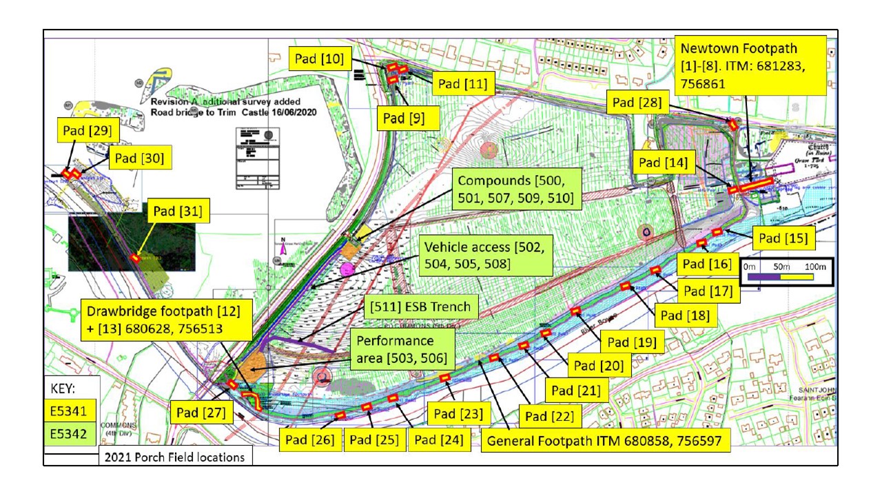
Archaeological monitoring took place of the Porch Field Footpath and Wild Flower areas upgrade project. The works were completed in conjunction with C670:E5342 Performance and Car Parking Areas.
The impact area was 21,877sq m in 30 locations, mostly east of the R154 measuring approx. 1km east-west x 595m. A further 7,559sq m had an impact on grass level only. One main area was a 50m x 1.8m length (90sq m) of footpath replacement alongside the Newtown Trim Cathedral ME036-049002 and Religious House ME036-049003. A second area was a 47m x 2m footpath and break-out area (108sq m) loop of footpath replacement around the ruined Drawbridge ME036-101. Another 21 areas were of limited size of 5sq m to 22sq m picnic table pads, litter bin pads, bicycle rack pads and information sign pads. Most of these were located on redeposited dredging dumps from OPW Boyne Drainage Scheme river clearance works around 1970. Many of these dredging dumps had to be tilled to smooth out irregular lumps and dips as well as bury exposed stones in an area of approx. 17,340sq m. A further 3,928sq m was slightly modified to infill the dips between cultivation ridges.
The Newtown Footpath and Drawbridge Footpath replacement works were up to 0.3m deep, although almost all of the material removed was from the previous footpath make-up. The rest of the works were limited to 50–200mm deep. Deeper excavations occurred in a few limited areas for exercise equipment that exposed the upper levels of natural gravels. Excavations took place from 30 June to 18 October 2021.
Zone 1: Newtown Trim
The Newtown Footpath replacement was in and around the medieval College and Cathedral ruins as well as a series of paddocks and a field system that appears to be post-medieval in date. An extensive, flag-stoned yard surface was exposed which was made or repaired in the post-medieval period. The Newtown works appeared to represent an active farm that was reusing the ruins of Newtown Trim as boundary walls and works areas. Livestock activity still occurs here to this day. The field system is reflected in linear ‘paddock’ banks still visible in the landscape. 36 finds included a worked stone reused from Castle ME036-049013 and a retracting knife.
Zone 2: Porch Field agricultural area
This area covers the agricultural headlands and open areas that form the post-medieval, rectilinear fields seen on OS mapping that contain the visible cultivation ridges that cover the Porch Field area. The topsoil of this field system is known to be post-medieval in date with coins of the mid-18th century indicating the presumed start of this phase of activity. There were occasional medieval finds from a possible earlier, medieval phase, but this area was perhaps focused more on grassland sheep farming during that period. 63 finds, including a 1790s Hibernian Mining Company ½ Penny token, an 1861 1 penny coin; 4 horseshoes, 2 harness buckles, 3 table knives (horse hoof cleaners), 33 nails, post-medieval and modern pottery and some iron slag.
Zone 3: Dredging dumps
This material is the product of OPW River Boyne dredging around 1970. At that time the River Boyne channel was entirely dredged and canalized with the removal of the riverbed material, as well as in-channel islands and weirs (often apparently armoured in stone). The 18th-century weir bypass channel associated with the 18th-century Drawbridge/Horsebridge was infilled and covered over at that time. The River banks were also formalized.
In the 1970s, the dredged material was mounded into bunds (interrupted by drainage channels) alongside the River Boyne. When the R154 Ring Road was constructed in the 1990s the mounds in that construction area seem to have been removed and spread around the previous Boyne floodplain, particularly in the area to the east of the Ring Road which was prone to flooding. The dredged material includes that in the areas of Blackfriary 2nd Division and Newtown.
The 2021 works were mostly concentrated on the 300m or so east of the R154 Ring Road. Further east and towards Newtown Trim, the works in the dredging area were very shallow and finds were generally limited.
The E5341 dredged area included 194 items allocated finds numbers. The finds seem to reflect food (and drink) waste, water collection material and domestic waste disposal washed downstream from Trim town. Some agricultural finds appear to show activities in the Porch Field and some lidded tins might have been associated with fishing (tobacco, bait or hook boxes etc.)
Finds included 1 harness buckle, 1 scythe head, 1 mantle clock, 1 iron Sacred Heart plaque, 1 copper alloy bowl, 25 tin bucket parts, 7 tin (stovetop) kettles, 5 lidded tins (perhaps for fishing bait), 5 horseshoes, 157 animal bones (not all retained), approx. 13 glass bottles, 37 fencing wire pieces, 15 nails, post-medieval and modern pottery, bedstead and mattress, a bicycle saddle, shell food waste and iron slag.