2021:544 - NAVAN 2030 SERVICES, ROAD and FOOTPATH WORKS OF 2021 LUDLOW STREET, MARKET SQUARE AND TRIMGATE STREET, Meath
County: Meath
Site name: NAVAN 2030 SERVICES, ROAD and FOOTPATH WORKS OF 2021 LUDLOW STREET, MARKET SQUARE AND TRIMGATE STREET
Sites and Monuments Record No.: ME025-044
Licence number: 19E0519
Author: Niall Roycroft
Author/Organisation Address: c/o Meath County Council
Site type: Excavation - miscellaneous
Period/Dating: Multi-period
ITM: E 686927m, N 767803m
Latitude, Longitude (decimal degrees): 53.652767, -6.685049
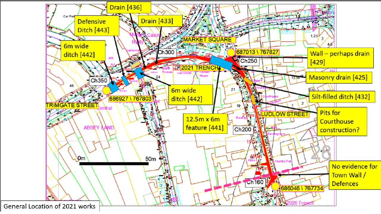
2021 Services works in Ludlow Street, Market Square and Trimgate Street, Navan (ITM: 686046, 767734 to 686927, 767803, Navan Townparks) consisted of a 200m long trench 1.5m to 3m wide by 1.5m to 2.5m deep. Following this, the road and the footpaths were relaid. Although the previously presumed Town Defences were not found, their line was marked in footpath cobbles in the area at Ludlow Street, The Foundry Public House and The Oriel shop. The service trench is referenced as Chainage (Ch) 160 to Ch350 for the purposes of this report and it ran through the heart of medieval Navan. The works were monitored for Meath County Council.
PHASE 1: NATURAL SANDS, SILTS, GRAVELS AND OCCASIONAL COBBLES
The natural sands, silts and gravels upon which Navan is built form a large knoll overlooking the confluence of the Rivers Boyne and Blackwater. Where not truncated, the sands can be less than 0.4m below modern ground level in Market Square to Trimgate-Kennedy Road junction (sands at 44.25-44.5m OD, Ch300-350). In these often quite small surviving islands cut by very many modern service trenches, the natural sands are covered directly by up to 0.2m of compacted gravels which presumably represent roads and open areas from the medieval period to the 20th century. Modern tarmac and road pavements of around 0.2m deep cover these gravels.
Along the line of the 2021 trench, Ludlow Street had almost all previous gravel roads, drains and the upper surfaces of natural sands removed during refurbishment works in 1996. Truncated natural sands in Ludlow Street at The Foundry and the associated underpass had dropped to 37.15m OD (Ch155-180) which is 0.6m below ground level. This is the area of the presumed Town Walls at The Oriel shop and large areas of sands were seen at 37.35m OD a little to the north of the Oriel shop
PHASE 2: POTENTIALLY MEDIEVAL 12TH-15TH CENTURY (OR EVEN UP TO 17TH CENTURY)
The trench only exposed modern service trench fills in the area Ch158-165 (the area of The Foundry Underpass). Extensive deposits of in situ natural sands were recorded throughout the area Ch165-180 – albeit with the upper surface removed. There was no evidence for any Town Defences (walls, ramparts or ditches), Roads or Town Gate in this area. It is possible:
- the Town Walls crossed the road at Ch158-165 which is slightly to the south of the presumed line or
- the area of the trench was a causeway for the Dublin Road to cross the Town Defences or
- they have been completely removed since they had no or very limited foundations or
- they were not here in the first place in the form of a wall with foundations (and possibly a ditch).
At the Market Square–Ludlow Street junction area Ch245-250, a 2m-wide masonry-built drain still containing a silty-clay fill and a nearby masonry fragment were found. They could be connected, as an outflow, with a 3m x 6m wide, over 1m deep, flat bottomed moat-like ditch that was found in Market Square Ch250-265 outside Clonard House–Woods Financial. This flat-bottomed feature showed a greeny-grey crust on the base where liquid had drained into the natural sands. The basal fills were fairly soft green-grey silts with few inclusions. The middle fills contained a lot of stones and animal bones stained by water action and the upper fills were redeposited natural sands, rocks and post-medieval pottery. Although a representative amount of this fill was dug by hand, no medieval pottery or any other pottery was recovered. However, it is likely that this moat-like feature originally dates to the medieval period and continued in use, possibly with regular clean-outs, until the early 18th century or so and it was then infilled with consolidation dumps. Market Square gravels were then laid directly on top of the backfilled feature in the 18th century or so and this seemed to represent the extension of the Market Square area to the extent seen on the 1756 Williams Map. The moat-like feature lies on the lower side of Market Square and had a terminus at the north end, but there is a possibility that it turned to the south-west at Clonard House and became a defensive ditch – which doubled as town drainage and dumping areas for domestic waste – that surrounded the southern side of medieval Navan before any Town Walls were built.
In support the above statement were two further ditches that were almost exactly the same in form (6m wide x 1m deep with flat bases) and lower silty green-grey fills capped with consolidation dumps to the ditch at Market Square. These ditches were both oriented north-south and located in Trimgate, one opposite the entrance to Old Cornmarket and the second opposite the Kennedy Road Junction. Between these two ditches was a further V-profiled ditch filled with the same type of fills. Other construction works at these locations showed these ditches did not cross Trimgate, but had causewayed crossing points for the east-west medieval Trim Road of Trimgate. This whole arrangement in Trimgate has the appearance of a Town Defences ‘gated’ area. The ditched features in Trimgate also had a reasonable amount of fills excavated by hand and a sample of butchered animal bones (cattle, sheep/goat, pig, bird) and a small piece of green-glazed medieval pottery was recovered.
By postulating a connection between all these three similar, large, moat-like features, it is possible that a large oval-shaped boundary to medieval Navan Town can be drawn. Most medieval towns, prior to being walled, do seem to have been oval in shape, often reflecting contours surrounding the motte and bailey basic defensive arrangement, e.g. at nearby Kells. The Town Defences of Navan as proposed by the Urban Archaeological Survey show a walled settlement that is considered to date from the mid-15th century. The Wall remains seen in Abbey Road (and suggested at the base of Timmons Hill) show that some of this circuit was masonry and works in Kennedy Plaza show that others seem to have been ditches and ramparts. The 2021 Ludlow to Trimgate works appear to show that the earlier suggested defences were retained as part of the town throughout the medieval period. The situation is also more complicated in that large rampart defences were constructed in both Trim and Kells during the 17th century. Such an additional 17th-century circuit or reconfiguration of parts of the circuit, could also have been constructed at Navan.
In addition, other Towns in Meath, e.g. Athboy, are historically recorded as being largely rebuilt in the 18th century and similar town reorganization occurred in Navan as well, as seen by the 1750’s New Bridge, the recorded widening and removal of the Town Gates and the organized developments seen on the 1756 Williams Map. Surviving islands (between service truncation) of gravel surfacings show Market Square open area expanding over the previous medieval moat-like feature. Other gravel surfaces in Market Square and Trimgate Street may originate in the medieval period and have simply been retained and reused.
PHASE 3 – POST-MEDIEVAL (18th to early 20th century) NAVAN TOWN
Ongoing development through the 18th to 19th century is discussed as Phase 3. Such a Town redevelopment involved quarry pitting, new roads, new drains, wells, new housing etc.
The Thomas Williams’ 1756 Map can be overlaid with the 1837 OS showing that the Navan street pattern had changed little between the two maps. The Williams’ Map has no indication of the suggested ‘medieval moat-like defences’ noted above. However, the line of Old Cornmarket and also of the Trimgate end of Kennedy Road may reflect the lines of these features. Market Square has been extended south to roughly its present limit by 1756.
In addition, some form of precinct may have existed around St Mary’s Church of Ireland church to include Fair Green and the Leighsbrook stream as suggested on the 1650’s Down Survey maps. The area around the ‘Bridewell’ (Town Hall, Abbey Road) was redesigned between 1756 and 1837. The Old Court House at the Toberorum on Ludlow Street was built 1795-1805.
Ongoing redevelopment continued throughout the 19th century and shows further redesign of Market Square to Ludlow Street area, the buildings of Market Square to Trimgate are rebuilt with the present examples. Features noted in 2021 that are presumably from this phase consisted of pits (one apparently circular in shape in Market Square so perhaps being a well or soakaway). These pits were typically filled with late 19th-century broken beer bottles and demolition material. Another pit perhaps reflected a large construction cut connected with the building of the Old Court House and there were other apparent quarry pits or excavations to allow for nearby basements. Some 19th-century stone-built box drains—presumably a combination of surface and foul drainage—were noted in Trimgate Street.
PHASE 4: MID- TO LATE- 20TH CENTURY SERVICES AND ROAD LAYOUT
The 2021 works exposed very many modern underground services, including numerous replacements and upgrades, connected to modern Navan. The mass of services left very limited islands where archaeology could be viewed at a higher level.
In 1996, the road pavement area of Ludlow Street was entirely dug up to a depth cutting into natural sands. The footpaths were also redesigned at this time (removing previous stepped areas) but not perhaps to such a great depth. Also, numerous buildings on Ludlow Street have basements that extend underneath the footpath. Other buildings seem to have had large construction cuts in the footpath areas.
In several areas it was only the depth of the 2021 works descending below the upper 1–1.5m that allowed for deep-cut archaeological remains to be seen. In other areas it was because the 2021 works zig-zagged to avoid existing services and so entered previously untruncated ground.
Further works for Navan 2030 in Kennedy Road and along the northern side of Market Square are programmed for 2022.