2021:071 - CARLINGFORD: Church Lane, Louth
County: Louth
Site name: CARLINGFORD: Church Lane
Sites and Monuments Record No.: LH005-042013/National Monument No. 623
Licence number: C000999, E005156, R000530
Author: Jon Stirland, Archaeological Consultancy Services Unit
Author/Organisation Address: Unit 21, Boyne Business Park, Greenhills, Drogheda, Co Louth
Site type: Graveyard
Period/Dating: Medieval (AD 400-AD 1600)
ITM: E 718940m, N 811463m
Latitude, Longitude (decimal degrees): 54.038613, -6.184119
Monitoring of topsoil stripping and test trenching took place at Church Lane, Carlingford, Co. Louth. Fieldwork was carried out in April 2021.
The site is located c. 8m to the east of the upstanding remains of Carlingford Abbey (LH005-042013, National Monument No. 623) and within the Zone of Notification of the medieva lwalled town of Carlingford, LH005-04.
The site was previously subject to test trenching, carried out in 2020. Eight test trenches were excavated. Archaeological material was identified in Trench 4 only. Features exposed consisted of two pits (cremated bone was retrieved from a fill of one of the pits), charcoal-flecked clay deposit, drystone kerb wall, and a ditch/shell deposit. These features and deposits were interpreted as representing a possible prehistoric barrow and two associated cremation pits.
In the course of monitoring, Test Trench 4, excavated during the previous test trenching, was re-excavated. Features within it were identified as post-medieval to modern in date. These features were represented by an east-west oriented dry stone retention wall, levelling deposits and one pit containing burnt animal bone, animal bone and oyster shells.
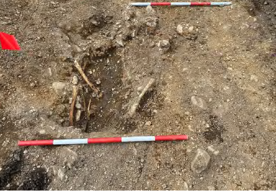
Human remains were encountered during monitoring of topsoil stripping of the footprint of the proposed development. The burials were exposed at a depth ranging between 0.35m (west end) to 0.8m (east end). The site was cleaned back by hand in order to identify any further graves or archaeological features. In total, twenty-nine (29) burials within their associated grave cuts were exposed in plan only. The burials are east-west oriented and represent extended inhumations in simple grave cuts.
These graves are likely associated with Carlingford Abbey. A high level of intercutting of the burials was observed. This suggests that a greater number of burials exist outside of the stripped area as well as around or below the cuts already identified. The cemetery likely extends to the north-west.
Following consultation with the Department of Housing, Local Government and Heritage, National Museum of Ireland and the Client it was decided that preservation in situ is the most feasible option.
The location of the burials was recorded in plan only. Subsequently, the area was covered with a layer of geotextile and sand and backfilled under archaeological supervision.
Three additional trenches were also excavated in the north portion of the site. This was carried out in order to assess the archaeological potential of that part of the site. All trenches were north-south aligned.
In total, 74 linear meters were excavated. In general, the trenches revealed rich dark organic silty clay topsoil and sod with a combined depth of 0.32–0.47m overlying a soft light yellow-brown sandy clay natural with infrequent small, rounded stones, pockets of glacial sand and gravel. No archaeological features or deposits were identified, and no finds were recovered from excavated trenches.