2021:164 - LIMERICK: Mungret Housing Development, Baunacloka, Dromdarrig, Caheranardrish & Moneteen townlands, Mungret, Limerick
County: Limerick
Site name: LIMERICK: Mungret Housing Development, Baunacloka, Dromdarrig, Caheranardrish & Moneteen townlands, Mungret
Sites and Monuments Record No.: N/A
Licence number: 20E0550
Author: Seán Shanahan & Edel Barry; Shanarc Archaeology Ltd.
Author/Organisation Address: Unit 39a, Hebron Business Park, Hebron Road, Kilkenny
Site type: No archaeology found
Period/Dating: N/A
ITM: E 554330m, N 653331m
Latitude, Longitude (decimal degrees): 52.629281, -8.674611
Archaeological testing was carried out under licence no. 20E0550, by Shanarc Archaeology Ltd. in relation to Stage 2 of Limerick City & County Council’s Mungret Housing Development & Associated Infrastructure Project under the Local Infrastructure Housing Activation Fund (LIHAF). The development consists of a circa 1.7km link road, representing a continuation of Stage 1 of the scheme, Stage 1 having been constructed from the R510 to the north-east end of Stage 2. The route corridor for the link road was between 35m and 50m wide; also included in the works were an attenuation pond, adjoining the route corridor to the east end of the scheme.
The link road scheme traverses the townlands of Baunacloka, Dromdarrig, Caheranardrish and Moneteen, all of which are located in the Barony of Pubblebrien, and the Civil Parish of Mungret.
No known monuments are directly impacted by the route corridor, but the development area is of high archaeological potential, with the scheme partly sited within the south-east periphery of the Zone of Notification for LI013-009, a historic town, and partly within the north extent of the Zone of Notification for LI013-133, an enclosure site.
Test-excavation commenced over the period 20–22 October 2020, with outstanding test-excavation completed over the period 19–21 July 2021.
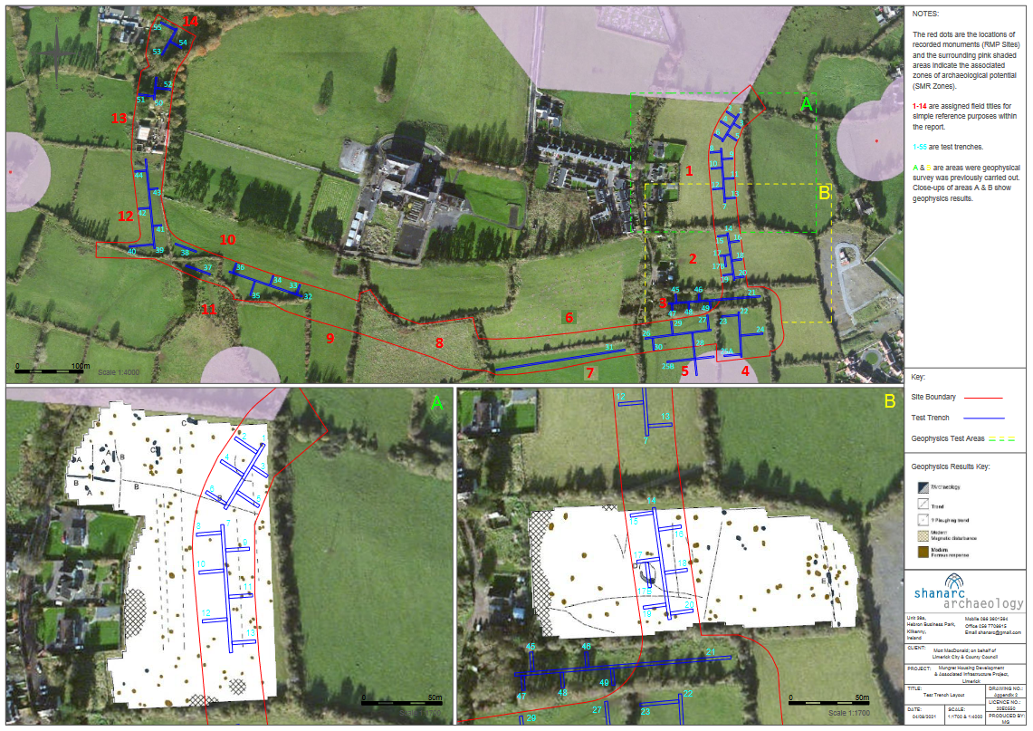
Testing comprised a centreline trench, excavated along the length of the scheme with regularly-spaced offsets, running perpendicular from the centreline to the edge of the scheme corridor. Fields 6, 8 and 9 were not tested as these had been previously subjected to geophysical survey (licence no. 19R0128) and archaeological testing (licence no. 19E0542) by Aegis Archaeology Ltd.
A total of 50 test trenches (Trenches 1–44 and 50–55), were machine excavated on the link road scheme to assess the impact of site development on potential sub-surface archaeological remains. Five trenches, 45–49 inclusive in Field 3, the original proposed site of an attenuation pond, were not excavated following the selection of an alternative attenuation pond location to the south side of the link road corridor in Fields 4 and 5.
In Fields 1 and 2, the centreline trench and offsets were so placed to target potential archaeological features identified during geophysical survey (licence no. 18R0224).
A mechanical digger with a flat grading bucket was used to excavate the trenches. Excavated trenches were 1.8m in width, with lengths of between 10m-133m and depths varying from 0.1m–1.74m.
No archaeological features finds or deposits were found during testing.