2021:799 - The Bungalow, 16 Troy's Gate, Bishop's Hill, Kilkenny, Kilkenny
County: Kilkenny
Site name: The Bungalow, 16 Troy's Gate, Bishop's Hill, Kilkenny
Sites and Monuments Record No.: N/A
Licence number: 21E0011
Author: Seán Shanahan; Shanarc Archaeology Ltd.
Author/Organisation Address: Unit 39A, Hebron Business Park, Hebron Road, Kilkenny
Site type: Urban
Period/Dating: Modern (AD 1750-AD 2000)
ITM: E 650323m, N 656661m
Latitude, Longitude (decimal degrees): 52.658797, -7.256156
Archaeological monitoring of groundworks at the site of a permitted residential development at Bishop’s Hill, Kilkenny City were carried out in April 2021.
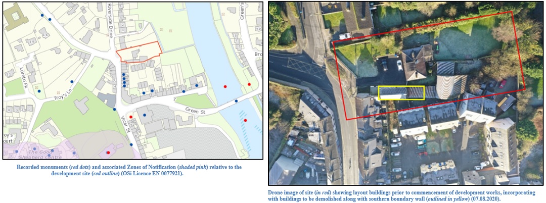
The development site is located immediately outside of the Historic Town of Kilkenny (KK019-026), the northern boundary of which is situated approximately 25m to the south of the proposed development site. Historic maps indicate that the Irishtown wall ran immediately south of the development site; the City Walls (KK019-026001), are recognised as a sub-element of the historic town.
Archaeological monitoring comprised of the demolition of a 12m length of a stone boundary wall, and groundwork associated with the excavation of foundations for a new studio apartment and extension to an existing dwelling at the site.
Monitoring work commenced with the removal of a small internal gable wall largely composed of red brick and beach-rolled stones, bonded with a lime mortar. The main boundary wall, comprising occasional medium-sized, roughly-squared limestone blocks, and predominantly small- and medium-sized rolled limestone, bonded with a friable sand and cement mortar, was subsequently demolished. A number of vertical cuts were created, to facilitate the safe demolition of the wall in sections. At foundation level, three cut limestone architectural fragments were retrieved, thought to have formed three components of the same feature, likely a windowsill. The boundary wall was excavated to foundation level, to a depth of 1.4m below ground level to the north, and 0.3m below ground level at the property to the south, Troys’ Gate. It was 1m in width at this point.
The stratigraphy evident in the south-facing section of the foundation comprised a layer of concrete slab, 0.15m in depth, overlying a rubble layer of limestone blocks, combined with occasional red brick fragments, and beach-rounded stones. A narrow internal wall, located approximately 4m from the east end of the trench measured 0.47m in width, and comprised roughly squared small-sized limestone blocks, bonded with a lime mortar. West of this dividing wall, the stratigraphy comprised a moderately compact, mid-brown sandy silt, with occasional small sized sub-rounded stones. In the north-facing section, the stratigraphy differed substantially; the material comprised a layer of dark brown, gritty sandy silt, with a moderate amount of small rounded pebbles, measuring 0.30m in depth.
Concrete was poured for the reconstruction of the boundary wall.
The area of the new build studio apartment which was to be located on the site of a former workshop was excavated following the demolition of the boundary wall and the trench for its replacement. The excavated material from this area comprised two separate deposits, both of which were created as a result of infilling, to raise the ground level for the pre-existing dwelling. A narrow gable wall, associated with the earlier building, and which had been removed at the start of monitoring work, had formed the dividing line between the deposits. To the east of this, the deposit comprised a dark brown, loosely compacted, sandy silt, with a moderate amount of small and medium-sized sub-rounded stones, and occasional fragments of red brick. This deposit extended approximately 5m from the gable wall. At the north-west corner of the foundation trench, a subsoil deposit, comprising a mild orange-brown sandy silt, with moderate inclusions of small, sub-rounded stones, was revealed. Nothing of archaeological interest was noted within. To the west of the gable wall, the deposit comprised a golden-brown material, comprising predominantly of building debris, mortar, stone and brick. This deposit of demolition debris also encompassed the north foundation trench. A number of cut limestone pieces were noted amongst the rubble layer; these comprised a saddle stone; two door jamb-stones with recessed rectangular slots to accommodate a door frame.