2021:359 - KILKENNY: Good Shepherd Centre, Church Lane, Kilkenny
County: Kilkenny
Site name: KILKENNY: Good Shepherd Centre, Church Lane
Sites and Monuments Record No.: N/A
Licence number: 21E0143
Author: Orla Scully
Author/Organisation Address: 7 Bayview Tramore X91 X462
Site type: Historic town
Period/Dating: Multi-period
ITM: E 650164m, N 656512m
Latitude, Longitude (decimal degrees): 52.657473, -7.258529
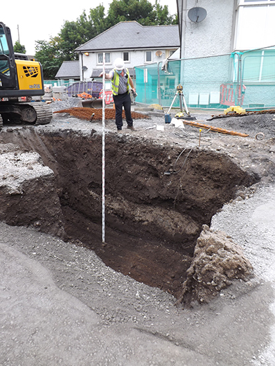
Monitoring was carried out during the excavations for building of 2 apartment blocks in the grounds of the Good Shepherd Centre, Church Lane, Kilkenny. The site, most particularly the eastern and northern portion of the former garden area of the former convent, has undergone several phases of infill (the underlying topography slopes from west to east and south to north). The most recent of these fills is associated with the first phase of building of social housing in the grounds of the Good Shepherd Centre which opened in 2007. The topsoil in the central garden area overlay earlier dumping, much of this demolition debris containing stone, red brick and associated mortar in brown silt. The depth of the built-up ground in these areas was exceptional. Even after clearance of topsoil and modern building debris, the ground in the area of Block 2 was exceptionally soft and foundations were dug to a depth of almost 2m, below surface clearance. Due to the precarious depth of the foundations, and the instability of same, the concrete had to be poured almost immediately, not allowing for access to much of the foundation trenches on safety grounds. The basal organic-rich soil was the result of rapid deposition of domestic refuse, with pots from the 13th/14th century. Survival of this type of the build-up of occupation or cultural layers was seen also in the city of Waterford, where the cumulative effect of in situ discarding of domestic refuse, possibly coupled with some very wet weather, (there are multiple annalistic references to flooding events in the mid-14th century, Barry, 1997, 16), created deep layers of organic material where the rate of deposition exceeded the rate of decay. Cut from or below this basal organic silt, two pits were exposed, one of which [F6] contained cut antler and animal bone waste, including horns. The pits were cut into boulder clay. This finding, on the sloped hill below St Canice’s cathedral, echoed the findings of the excavations by Ó Drisceoil (11E0157) in the nearby Robing Room of the former Bishop’s Palace. These early pits with antler waste were dated to c.1000-1140 cal AD (Ó Drisceoil, 2013, 25).
References
Barry, T 1997 ‘Waterford, A Historical Introduction’ in Hurley M. F. and Scully, Ó Late Viking Age and Medieval Waterford, Excavations 1986 – 1992.
Ó Drisceoil, C. 2013 ‘Excavation and Archaeological Building Survey at the Robing Room, Heritage Council Headquarters (former Bishop’s Palace), Church Lane, Kilkenny 2011 & 2012 (11E157 & 11e157 ext): Final Report.