2021:321 - CASTLECOMER: 62A Kilkenny Street, Kilkenny
County: Kilkenny
Site name: CASTLECOMER: 62A Kilkenny Street
Sites and Monuments Record No.: N/A
Licence number: 21E0822
Author: Fiona Reilly & Marion Sutton; Shanarc Archaeology Ltd.
Author/Organisation Address: Unit 39a, Hebron Business Park, Hebron Road, Kilkenny
Site type: Watercourse
Period/Dating: Multi-period
ITM: E 653235m, N 672591m
Latitude, Longitude (decimal degrees): 52.801682, -7.210535
Archaeological monitoring of groundworks associated with the construction of a rear extension to a two-storey, semi-detached dwelling at 62A Kilkenny Street, Castlecomer, Co. Kilkenny, was carried out on 29–30 November 2021, in compliance with the conditions of Kilkenny County Council, Planning Reference No. 19/786.
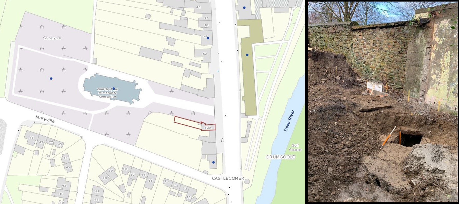
The northern boundary of the development shares a boundary wall with the grounds of the Catholic Church of the Immaculate Conception. Both the church and associated graveyard are protected structures (RPS Ref. C60 [church] and C689 [graveyard]; NIAH Ref. 12301039 [church] and 12301079 [graveyard]).
All groundworks, comprising soil stripping over the extension footprint and underpinning of the rubble stone boundary wall with the grounds of the adjacent Catholic Church, were subjected to monitoring. Soil stripping and excavations for wall underpinning were preceded by the removal of the unroofed structural remains to the immediate rear of the dwelling house, associated with an earlier extension, the removal of a former rear yard boundary wall and the removal of vegetation that covered the site.
Groundworks exposed a mortared stone boxed culvert oriented approximately north-south across the development site. The culvert was present below the northern boundary wall of the earlier extension, extending northwards into the church grounds. A shallow layer of silt in the base of the culvert contained 19th-century transfer print pottery sherds. Following assessment by the engineer it was determined that the culvert could be retained in situ below the level of the new extension raft foundation.
The garden to the rear of the former yard at the site was at a higher elevation, with excavations for wall underpinning requiring depths to 2.05m below the surface at the western extent of the works. The higher garden area comprised made ground, formed by 0.42m of dark brown moderately loose topsoil with occasional small stones, above 0.78m of mid-brown silty clay containing a moderate amount of small stones and very occasional brick fragments overlying natural, which was excavated to a depth of 0.85m for the purpose of wall underpinning. Natural across the extent of the groundworks comprised a mid- to light brown gravelly clay with frequent sub-round to sub-rectangular stone.
With the exception of the modern stone culvert, no other features of archaeological or architectural interest were exposed during groundworks.