2021:244 - THOMASTOWN: Lady's Well Street, Newtown, Kilkenny
County: Kilkenny
Site name: THOMASTOWN: Lady's Well Street, Newtown
Sites and Monuments Record No.: N/A
Licence number: Unlicensed Monitoring
Author: Fiona Reilly; Shanarc Archaeology Ltd.
Author/Organisation Address: Unit 39a, Hebron Business Park, Hebron Road, Kilkenny
Site type: No archaeology found
Period/Dating: N/A
ITM: E 658185m, N 642408m
Latitude, Longitude (decimal degrees): 52.529918, -7.142462
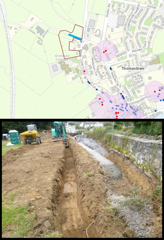
Unlicensed archaeological monitoring was carried out on 21, 24 and 30 September 2021, in compliance with An Bord Pleanála Board Order ABP-307542-20 in Newtown townland, off Lady’s Well Street, Thomastown, Co. Kilkenny.
The monitored groundworks relate to the relocation of a c.72m long section of stone boundary wall to the north side of local road L8202, to provide a 6m wide road with a 2m wide public footpath. The boundary wall formed part of the curtilage of a protected structure, a former Church of Ireland ‘Glebe House’ (RPS reg. nos. C384 and C632; NIAH Reg. No. 12317086).
Trees and briars were removed before topsoil stripping commenced. The drainage ditch noted on historic Ordnance Survey maps behind the boundary wall was open and visible at the west end of the works; it was not visible along a 32m lineal stretch at the eastern end, toward the junction with Lady’s Well Street and the Kilkenny Road. The visible drain measured approximately 1.8m in width and was 0.9m deep from the foundation level of the wall.
The excavated area to the rear of the boundary wall was narrower at its western end, where it measured 2.5m north to south, and widened towards the east to c.4.8m in width north-south. Topsoil stripping was carried out to a depth of 0.8m below the current ground level. A concrete structure was noted at the eastern end of the site, and was partially destroyed during the work; this structure was fed by a spring located in a grove of trees to the immediate north-west, and the water continues beneath the Kilkenny Road to the east.
The topsoil layer was mid-brown, moderately compact, silty clay with a moderate amount of small sized, sub rounded stones. The underlying subsoil layer comprised compact, orange/brown silty clay with occasional to moderate amounts of small and medium sized, sub-rounded stones.
A new drainage channel was excavated behind the foundation trench for the relocated wall; the channel measured 0.75m in width by 0.85m in depth.
No archaeological features, finds or deposits were identified during the monitoring.