2021:561 - DÚN AILINNE, Kildare
County: Kildare
Site name: DÚN AILINNE
Sites and Monuments Record No.: KD028-038 (including -038001 through -038006)
Licence number: E0004689 (C000748)
Author: Susan Johnston, George Washington University
Author/Organisation Address: 14111 Westholme Ct., Bowie, MD, 20715 USA
Site type: Ceremonial enclosure
Period/Dating: Iron Age (800 BC-AD 339)
ITM: E 681962m, N 707912m
Latitude, Longitude (decimal degrees): 53.115462, -6.775661
A four-week excavation was carried out at Dún Ailinne, Co. Kildare, during June and July of 2021 in the context of an archaeological field school. The goal was to continue the excavation of two ditched enclosures identified through a magnetometer survey (2006-2008). These two features are circular and appear to intersect each other, the one to the north slightly larger than the one to the south (18m diameter versus 14m diameter respectively). They are located within a large enclosure that rings the summit of the hill (identified through magnetometer survey and explored through excavation in 2016) but are about 50m to the north-northwest of the Iron Age timber structures identified in excavations from the 1960s and 1970s.
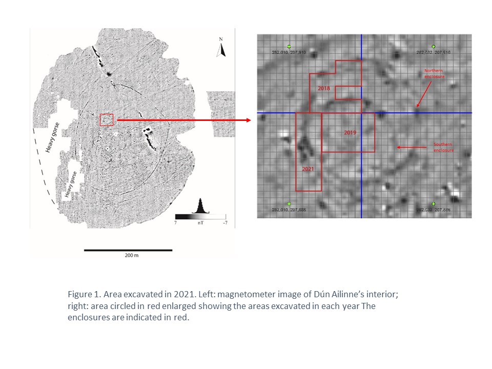
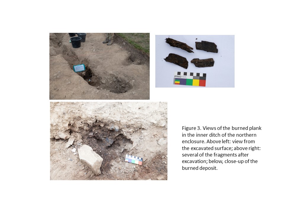
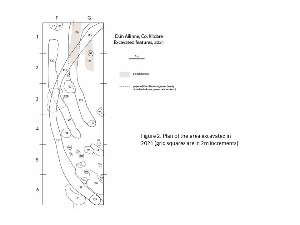
In 2021 we extended the sections of these enclosures excavated in 2019 (Figure 1). In this season, the western edges of the two enclosures were excavated in order to establish further their characteristics and also trace the relationship between them. Both the outer and inner ditches of the northern enclosure were identified and excavated (Figure 2). The outer ditch was cut by a post-hole where it emerged into the cutting, but since it was not completely coterminous with the ditch it may be a later feature. There was also a large post-hole in the inner ditch, this one completely within the ditch itself, apparently marking a gap in this feature. The inner ditch was also recut at some point in its history, raising the possibility of a more complex monument. In addition to these characteristics, 30+ fragments of burned plank were found lying against the inner surface of the inner ditch wall (Figure 3). The deposit also contained fire-affected rock and burned clay. It may be the remains of a revetment, though the lack of any similar deposits anywhere else along the ditch suggests it may instead be material introduced into the ditch when it was filled in. In this case, its position along the wall of the ditch may be coincidence.
The southern enclosure was also identified but proved somewhat problematic. While its northern portion was identified clearly in 2018, its continuation is unclear. In 2019, a ditch which was believed to be its continuation was excavated, running to the south and curving slightly to the east towards its end. While it did not match up directly at its north end with the section of the ditch excavated in 2018, it was very close (being offset by only about 0.3m) and so seemed the most likely candidate. However, in 2021, another candidate for the continuation of the southern enclosure was identified, this one containing a post-hole at its end; because this ditch section ran into the south-east corner of the cutting at this point, it was difficult to determine whether the post-hole marked the end of the ditch or was simply positioned within it. Because of later disturbance, neither of these ditch sections can clearly be connected with the section of the enclosure excavated in 2016. This remains to be resolved by future excavation.
Excavation of these features established stratigraphically that the large, double-ditched enclosure (the one to the north) underlay the smaller, single-ditched enclosure (the one to the south). However, the radiocarbon dates obtained were contradictory to this interpretation:
QUB # Feature
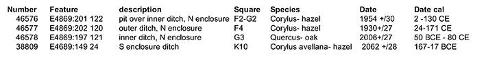
This may be because of some problem with the samples chosen, but more likely this is due to complexities in the identification of the continuation of the southern enclosure, which was disturbed by later ploughing. We intend in future seasons to resolve this issue with more precise radiocarbon sampling and further excavation.
In addition to the enclosure ditches, we excavated a number of post-holes and several pits (some of them large), as well as plough furrows. There were sixteen post-holes in total, including the two that were associated with the enclosure ditches. Most of the others were scattered in the southernmost part of the cutting and formed no obvious patterns, though several were distributed in a rough arc. The shapes and fills of the post-holes varied, and some had associated stones, though none could clearly be identified as packing material. In addition to the post-holes, six pits were also excavated. Three of these were stratigraphically related to the ditches, two of them more recent and one earlier. The others could not be related to the ditches on the basis of stratigraphy. Finally, three plough furrows were also excavated, continuing a pattern seen in previous excavations of these enclosures. All ran north-south.
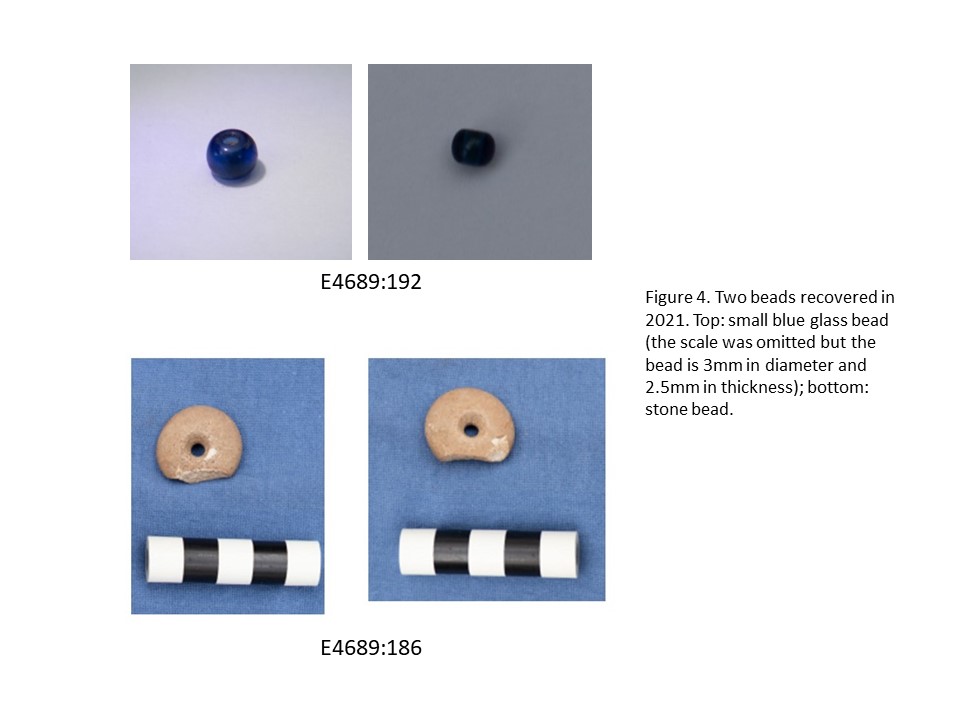
As is common at Dún Ailinne, cultural objects were rare and only nine artifacts were recovered. Five of these were from the sod and only four artifacts were recovered from features. Samples of possible slag were also collected. Six of the nine objects were lithics, two implements (a small flint scraper and another flint implement with retouch around its circumference) and four unmodified flakes (two of flint and one each of chert and quartz). The other two objects were beads. One was very small (3mm in diameter and 2.5mm thick) and made of dark blue glass (E4689:192). The other bead was stone (E4689:186), broken on one side but otherwise intact; its maximum diameter is 26mm. While its specific chronology is unknown (it came from redeposited material), it is likely Neolithic based on its general configuration and various comparative material (e.g. Tara). All artifacts and samples are now in the National Museum and a preliminary report has been submitted to the National Monuments Service.