2021:409 - NUI MAYNOOTH, Kildare
County: Kildare
Site name: NUI MAYNOOTH
Sites and Monuments Record No.: N/A
Licence number: 19E0535
Author: Philip Quilty, Archaeology Plan Ltd
Author/Organisation Address: 32 Fitzwilliam Place, Dublin 2
Site type: Excavation - miscellaneous
Period/Dating: Prehistoric (12700 BC-AD 400)
ITM: E 692777m, N 737983m
Latitude, Longitude (decimal degrees): 53.383861, -6.605411
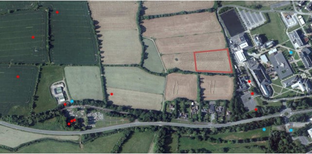
Archaeological excavations took place at Maynooth due to planning requirements (Kildare Planning ref.(19/622) within the footprint of a proposed student centre on the outer limits of NUI Maynooth, within an area of high archaeological potential. The excavation took place in October 2021 during mixed weather conditions.
The excavation began on 30 September 2021, and was followed by two weeks of archaeological investigation and excavation. Topsoil varied between 0.2m and 0.3m in depth.
The natural composition of the site’s geology was identified to be two distinct layers, an upper standard clay topsoil (C01) above a mix of silty clay natural subsoil (C02) which varied in colour between light grey and light yellow, with frequent patches of small sub-rounded stones. All recorded features were cut into the lower
layer (C02).
The identified and investigated features can be broken down into four distinct groups/types.
1: Remnants of a burnt stone spread (fulacht fiadh) and associated pits
2: Charcoal production
3: Pits/unclear
4: Modern/agricultural features
These features were subsequently excavated by hand by a team of five.
The close proximity of the excavated features to a cluster of features c. 100m to the east, which include a ring-ditch, an enclosure, a trackway and a field system (KD005-010, -011001, -011002 and -012) is notable. It is possible that those occupying the enclosure to the east created some of the features identified during the excavation.
An additional possible enclosure lies approximately 100m to the south-west of the excavation area on the Laraghbryan East townland boundary. This feature is situated on a high point in the landscape and measures approximately 60m in diameter. On the ground, it is defined on its northern extent by the townland ditch and a copse of trees. The southern eastern and western extents are clearly visible and the ground rises from the edges towards the center to form a hillock. The people that constructed the townland boundary of Laraghbryan East most likely chose to navigate around the monument and possibly incorporate any pre-existing ditch into the boundary itself. The curve of the townland boundary around this feature can clearly be seen on the 6 inch and 25 inch OS maps.
The fulacht fiadh uncovered on the site is likely to date to the Bronze or Iron Age. The ring-ditch to the east also suggests a prehistoric date. It is possible these were created or used by the same people.
The charcoal-production pits excavated on the site may be later in date, possibly dating to the Iron Age or into the medieval period. They were associated with the rise in demand of charcoal for iron production and again may have been created by those dwelling nearby. It is also possible that, as a more dangerous activity, this may have been carried out at a distance from a settlement, perhaps by the ecclesiastic community at Laraghbryan or the medieval settlement at Maynooth itself.
A more detailed understanding of the site and how it fits within its archaeological landscape will be possible once the specialist analysis and radiocarbon dates are returned.