2021:089 - GURTEEN NORTH (2), Kerry
County: Kerry
Site name: GURTEEN NORTH (2)
Sites and Monuments Record No.: N/A
Licence number: E005290
Author: Tony Bartlett, Archaeological Management Solutions Ltd.
Author/Organisation Address: Fahy’s Road, Kilrush, Co. Clare
Site type: Hearth and Pit
Period/Dating: Multi-period
ITM: E 458862m, N 601635m
Latitude, Longitude (decimal degrees): 52.148507, -10.062379
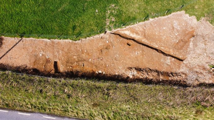
Stage (iii) Excavation was carried out between 05 April and 16 April 2021 at the site of Gurteen North 2 in advance of construction of the N86 Ballynasare Lower to Annascaul and Doonore North to Ballygarret Road Improvement Scheme, Co. Kerry. The work was carried out under Ministerial Direction Number A070 and Registration Numbers E005290 (Excavation) and R00545 (Metal Detection), on behalf of Kerry County Council. The site was discovered in the eastern section of the scheme in the townland of Gurteen North during advance Stage (i) Test Excavations undertaken in 2020 by AMS.
Gurteen North 2 consisted of a hearth and seven pits. Post-medieval/modern agricultural features comprising a field boundary ditch, drainage ditches and furrows were also excavated. The hearth comprised an area of in-situ burning of the subsoil, overlain by a charcoal-rich cultural deposit that consisted of loosely compacted black sandy silt with frequent charcoal and occasional small sub-rounded stones. It was subcircular in plan and measured 0.75m by 0.62m by 0.02m in depth. The hearth had an abutting pit which was sub-oval in plan and measured 1.28m by 1.15m by 0.13m in depth and contained a single fill.
Two intercutting pits were located at the southern extent of the central area of the site and extended beyond the limit of excavation. The earlier pit was irregular in plan and measured 6m by 2.8m by 0.4m in depth within the excavation area and contained four fills. All four fills within the pit appear to have been deliberate backfill episodes, before another smaller pit was dug through it. The later pit was sub-oval in plan and measured 1.9m by 0.7m by 0.7m in depth within the excavation area and contained three fills. The remaining four pits varied in shape and ranged from 0.4−3.7m in length, from 0.38−1.15m in width, and from 0.04−0.47m in depth. The larger pit contained two fills while the other three pits each contained a single fill.
Only a single artefact was recovered from the excavation, an unidentified iron object from the earlier of the intercutting pits. The nature and date of the archaeology at Gurteen North 2 are at present unclear. Post-excavation analysis is ongoing and it is hoped that specialist reports, including radiocarbon dating and comparative research, will further enhance our understanding of the site.