2021:081 - BARROW, Kerry
County: Kerry
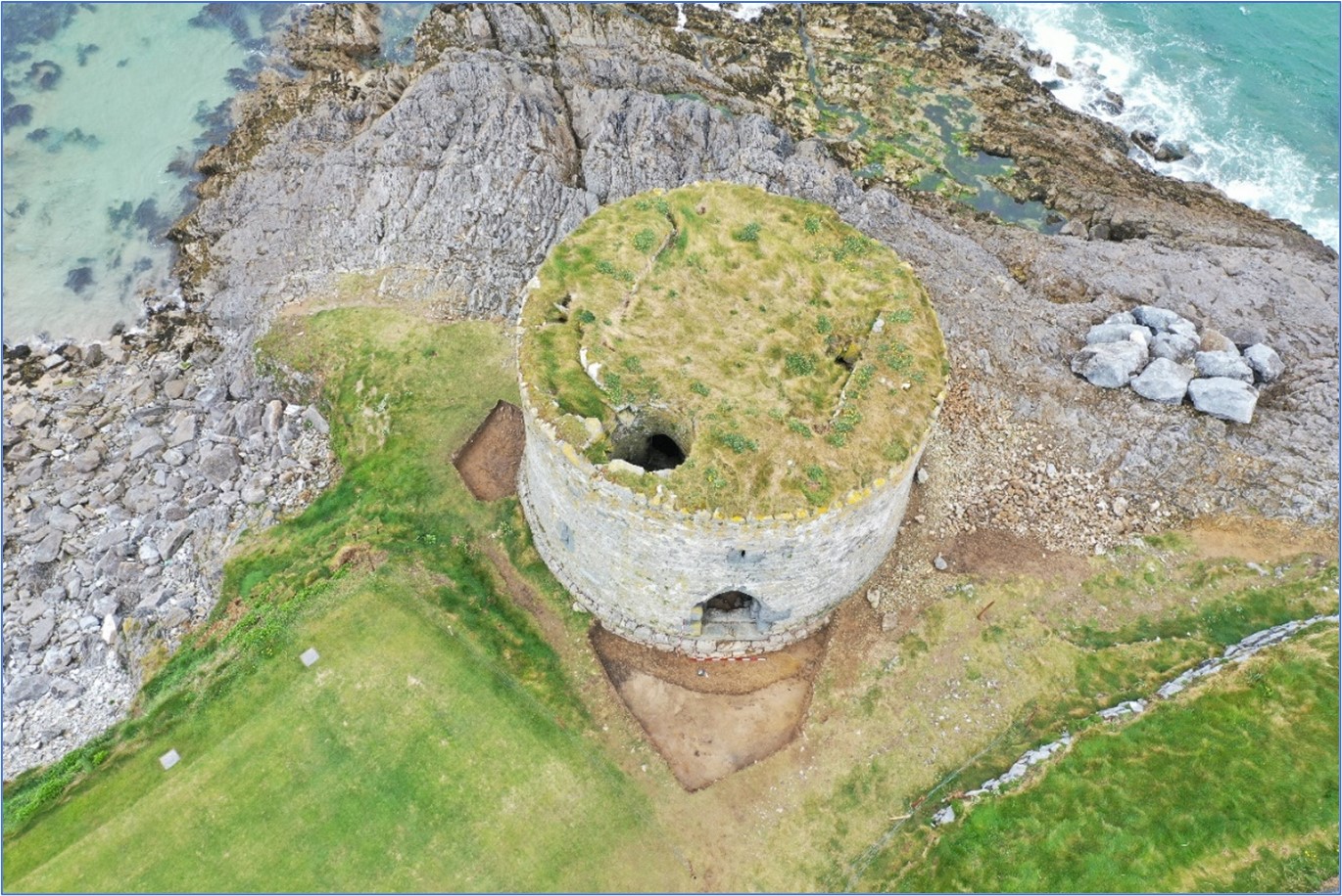
Site name: BARROW
Sites and Monuments Record No.: KE028-002001, KE028-002002
Licence number: 21E0126
Author: Laurence Dunne
Author/Organisation Address: 3 Lios na Lohart, Ballyvelly, Tralee, Co. Kerry
Site type: Promontory fort - coastal and Castle - tower house
Period/Dating: Multi-period
ITM: E 472525m, N 618389m
Latitude, Longitude (decimal degrees): 52.302343, -9.869161
Targeted excavations, comprising of five cuttings (Cuttings 1-5) were undertaken on the coastal headland of Tralee Golf Club at Barrow, Co. Kerry in March/April 2021.
Cutting 1 abutting the exterior eastern and south-eastern quadrant of the castle was excavated in two sections. The first part of Cutting 1 was opened outside the doorway of the castle and measured c. 6m (north-east/south-west) x 3m (north-west/south-east) x 3.6m (east-west). Excavated material comprised of a thin layer of sod that overlay a c.0.5m thick compacted introduced fill containing frequent medium sized sub-angular limestone inclusions. A dark thin organic layer comprising of original sod was noted at c.0.6m below present ground level. The excavated depth of the cutting varied from 0.5m in its southernmost limits to c.0.8m at the north where the introduced material achieved the greatest depth. Excavations immediately outside the entrance doorway revealed a deliberate placement of stones reflecting an ad hoc step to allow easier access up into the castle doorway. It comprised of large to medium sized sub-angular limestone pushed into a dark grey organic layer and contained two large dressed architectural fragments of dark limestone that were re-used as steps. Apart from the two architectural fragments, no datable material and no other medieval or post-medieval finds were found during excavation of the first part of Cutting 1 outside the castle doorway. The natural subsoil revealed in the 1m-wide narrow strip by the wall comprised of compacted stony orange silty sandy clay material. Four courses of the plinth were exposed with a maximum height of c.1m in the south part of the cutting. The second part of Cutting 1 was opened at southern exterior quadrant of the castle underneath the garderobe exit. It measured 2.5m (east-west) x 1.6m with a maximum depth of 0.4m in its eastern limits with bedrock being reached at c. 0.2m at its western end. Excavated material comprised of thin layer of sod and orange to grey sand. A few sherds of modern pottery were recovered but no medieval or post-medieval artefacts or dateable material were found.
Cutting 2 was located immediately north of the castle on the ragged scoured seaward pedestrian approach below the 3rd Green revetment. Limited excavation within Cutting 2 was primarily focussed on a thin organic lens which involved the cleaning, straightening and recording of the existing ragged section where the thin organic layer was noted during previous field inspections. The poorly preserved uppermost surviving sod overlay a c.0.2m layer of yellow sand that overlay a stony, very compacted layer. Both layers were completely sterile. After removal of the stony material a thin lens of organic dark brown peaty fibrous material was exposed c.0.8m below the current ground level. A few modern glass fragments were recovered from this layer. The layer, which is presently interpreted as original sod, overlay natural bedrock. Nothing of archaeological interest was noted in Cutting 2.
The internal L-shaped Cutting 3 was opened in the ground floor chamber of the castle. There was no topsoil in Cutting 3 only a thin covering of windblown beach sand. The cutting measured 4m (north-west/south-east) x 2m and varied in width from 1m to 1.5m. Excavation commenced in the south-east corner of the ground floor with the removal of soft mid-brown putrid material full of very modern rubbish. This overlay surviving sections of mid to dark brown indurated material consistent with the remains of a rammed clay floor best preserved in the easternmost limits of the cutting. Some sherds of modern pottery and glass fragments were recovered from this thin layer. Below, a light yellow very compacted material was recorded but was only present at the eastern area of the cutting. It was interpreted as natural subsoil. The south-western section of Cutting 3 was quite different from its eastern part. Cleaning at and below the inside of the ragged fireplace ope involved removal of very soft dark material with frequent limpet shells and some modern pottery shreds. The fireplace itself has been entirely robbed out leaving only a few random stones arranged on the ground as an ad hoc fireplace setting. One of the re-used stones was a dressed architectural limestone fragment. No charcoal or charcoal-enriched deposit relating to the fireplace phase of the castle was noted. Removal of the soft material from inside the fireplace ope revealed compacted very stony mid-brown material. It was excavated to an average depth of c.0.4m and a max. of 0.7m under the fireplace but proved to be completely sterile, comprising of broken bedrock fragments. Due to the lack of any archaeological material, as well for safety, excavation ceased. A probable modified vertical section of bedrock was also recorded below the fireplace at the southern end of the cutting.
Cuttings 4 and 5 were opened through the fosse of the coastal promontory fort KE028-002002. Cutting 4 measured c.12m (north-west/south-east) x 2m and was excavated to a maximum depth of c.0.6m at the southernmost limits of the fosse. Beneath the top sod layer two sterile layers of sand were exposed. Protruding natural bedrock was exposed at the south-east side of the fosse cut. The cut of the fosse revealed gently sloping sides and a rounded base. No artefacts were recovered from Cutting 4 and no datable material was noted.
Cutting 5 measured c.16m (west-north-west/east-south-east) x 2m and was opened at the mid-section of the promontory fort fosse with its west-north-west end targeted on the possible hut site noted on an aerial image. The maximum depth of excavated material was c. 0.4m and comprised of mostly sterile sandy fills. Some charcoal was noted at the basal fill. The cut of the fosse in Cutting 5 was very similar to that in Cutting 4 with gently sloping sides and rounded base with exposed bedrock on the west side and at the base. At c.3.6m west of the cutting of the fosse a stony surface comprising of medium to small sized shattered limestone was recorded. This has been preliminarily interpreted as the basal remnants of the fabric of the bank of the promontory fort. Finds recovered from Cutting 5 include a few modern pottery fragments.