2021:796 - N83, Claregalway Traffic Calming Scheme (attenuation pond), Claregalway (Baile Chláir), Galway
County: Galway
Site name: N83, Claregalway Traffic Calming Scheme (attenuation pond), Claregalway (Baile Chláir)
Sites and Monuments Record No.: GA070-111003
Licence number: 20E0700 & 20R0250
Author: Kate Taylor, TVAS (Ireland) Ltd.
Author/Organisation Address: Ahish, Ballinruan, Crusheen, Co. Clare
Site type: Habitation site, Kiln- corn-drying and Metalworking site
Period/Dating: Late Medieval (AD 1100-AD 1599)
ITM: E 537260m, N 733200m
Latitude, Longitude (decimal degrees): 53.345302, -8.942219
Test Excavations took place at the location of a proposed attenuation pond, part of the proposed N83 Claregalway Traffic Calming Scheme, Co. Galway; test trenching was carried out in two phases, in December 2020 and in March 2021. The works were located on the northern edge of the modern village of Claregalway. Although a pasture field, this area has previously been used as a construction site compound by the OPW and it is believed that both dredged material from the river and imported hardcore were laid across the field
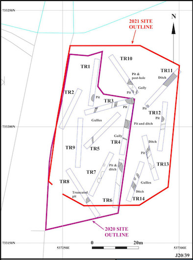
Fourteen trenches were excavated in the two phases of fieldwork, examining 17% of the proposed development site. Eleven trenches revealed features of archaeological potential: ten pits, five ditches, seven gullies, a post-hole and another possible ditch or drain. Two of the pits and one of the gullies contain substantial amounts of iron slag, whilst most features yielded animal bone and oyster shell.
Summary results
In summary, test trenching revealed a large area of archaeological interest in the eastern half of the proposed development site and extending beyond its limits to the east. These features are consistent with an occupation site and artefact analysis and radiocarbon dating suggests a 13th-century date for the activity, which includes evidence of iron smelting, smithing and forging as well as cereal processing. Artefacts from the site include medieval pottery and metal items. Part of the site and some features have been truncated by mechanical activity relating to use of the field as a construction compound for flood relief works in the last decade. Fortunately much of the area survives beneath a layer of imported fill that masks earthworks that were previously identified in the field, including monument GA070-111003 (enclosure).
Should development proceed then full archaeological excavation, is recommended.
Detailed results by trench
Trench 1 situated on the northern edge of the site revealed a single potential archaeological feature (pit 1).
Trench 3 was situated at the north-eastern end of the site and revealed three features of archaeological potential. At the west was gully 3, aligned approximately south-west to north-east across the trench at a depth of 0.6m below the modern surface. Gully 2, found at a depth of just 0.25m below the modern surface, was filled with fairly sterile, mid-orange, sandy clay with occasional stone inclusions. At the eastern end of the trench at the junction with Trench 4 is a pit (4) with visible dimensions of 3.5m by 2.53m and 0.68m deep. This pit contained charcoal and burnt material, and also yielded finds of iron smithing slag and fuel ash cinders, in addition to animal bone. A radiocarbon determination on a cow tooth from one of the fills of pit 4 returned a date of cal. AD 1176–1270 to 2 sigma (UBA46986, 823±26).
Trench 4 extended south from the eastern end of Trench 3, allowing the full width of pit 4 (described above) to be exposed. Four features were recorded in this trench. In the southern half of the trench was east to west aligned gully 6 that contained a large amount of iron smithing slag and hammerscale, as well as a medieval iron horseshoe nail and animal bone and shell was recovered from the small excavated slot. In the centre of the trench was pit 11, which is in turn truncated by ditch 5. Pit 11 yielded animal bone, along with whelk, periwinkle, mussel and oyster shell, cereal grains, weed seed and chaff, hazelnut shell, broad bean and charcoal, suggestive of discarded waste from cereal processing and drying. A radiocarbon determination on a sheep or goat bone from pit 11 returned a date of cal. AD 1227–1298 to 2 sigma (UBA46985, 738±27). Ditch 5 truncated pit 11 and was itself truncated by a parallel ditch or drain (12) that also crossed the trench. At the southern end of the trench a layer of firm, dark grey, silty sandy loam (64) was found overlaying the natural subsoil. This material, which was seen to be up to 0.24m thick, is thought to represent original occupation material including midden material, perhaps medieval in date.
Trench 5 was aligned south-west to north-east and positioned between Trenches 3 and 4, revealed two areas of archaeological interest. Gully 7 at the south-western end of the trench could possibly be a continuation of gully 3 in Trench 3. Overlying this feature at the southern end of the trench was occupation material, as described above.
Trench 6 was positioned south of Trench 4 on the same alignment, in the south-east part of the site. At the northern end of the trench was pit 10, which was in turn truncated by ditch 8. Ditch 8 crossed the trench at an angle, with a north-west to south-east alignment, and yielded an iron nail shaft as well as slag, animal bone including dog and fish as well as periwinkle and oyster shell. Charred cereal grains, weed seeds, chaff and a pea, in addition to hazel, oak and ash charcoal, was recovered, perhaps deriving from cereal processing and drying. A radiocarbon determination on a dog bone from ditch 8 returned a date of cal. AD 1270–Ki1387 to 2 sigma (UBA-46984, 716± 33). Overlying pit 10 and ditch 8 at the north of the trench and the natural subsoil elsewhere, was the same occupation layer as seen elsewhere.
Trench 8 was excavated towards the south-western corner of the site. Pit 9 was found at a depth of 1.1m below the modern surface and was truncated by a large machine-dug pit containing large rocks, gravel and modern rubbish. The pit contained a large amount of iron smithing slag and hammerscale. The occupation layer was seen overlying the pit, then being sealed by buried topsoil and a thick layer of imported fill sitting on a protective membrane.
Trench 10 was at the north of the site and revealed two pits, a gully and a post-hole. Pit 13 was the northernmost feature recorded. This ill-defined pit extended north-west beyond the edge of the trench and was truncated by a modern machine cut. The pit yielded a sherd of medieval pottery from the late 13th to 14th century, a piece of ceramic tile, a medieval iron horseshoe nail and finds of horse, cattle, sheep/goat and unidentified mammal bones and limpet and oyster shell. Two fills yielded charcoal from oak, ash, hazel and willow in addition to the largest assemblage of charred seeds from the site, consisting of cereal grains, weed seeds and chaff and legumes. The charred assemblage appears to be waste from cereal processing and drying, with the charcoal representing the fuel used in a cereal-drying kiln. In the centre of pit 13 was another cut feature (22) possibly a post-hole for a large square-section post. Pit 14 to the south was only partly exposed but contained fragments of iron smithing slag, sheep/goat, pollock and unidentified animal bones and oyster shell. Charred cereal grains, weed seeds and hazelnut shell were identified. Gully 15, slightly curved in plan, was in the south-east corner of the trench. A worked bone spindle whorl was recovered from the gully, it also yielded unworked cattle and unidentified bone and oyster shell and an assemblage of charred material, some of which appears to be waste from cereal processing and drying, with three separate fills apparently deriving from separate instances of burning. A radiocarbon determination on a cow bone from the fill of the gully returned a date of cal. AD 1223–1279 to 2 sigma (UBA46987, 773±27).
Trench 11, located in the north-eastern corner of the site, revealed that the natural subsoil, along with the archaeological features, had clearly been truncated. Two archaeological features were uncovered within the trench at a depth of approximately 0.25m below the modern ground surface. Pit 16 contained iron slag, probably waste from iron smelting, alongside animal bone and shell and a large amount of charcoal and some charred cereal grains, weed seeds and a pea fragment. The charcoal assemblage suggests that oak was used as fuel for the smelting furnace from which the slag derived. Ditch 17 was a large feature aligned south-east to north-west across the trench and widening at the north-west, towards the river, where it was 7m wide. The ditch was partly excavated, revealing it to be 0.8m deep with a gradual concave profile; it is cut into bedrock in its base. Ditch 17 produced the largest finds assemblage of any individual feature during testing, with a number of metal items identified by the use of a metal detector. These metal items represent medieval activity and include a decorated copper-alloy strap end, two small decorated fragments of copper-alloy binding strip, one copper-alloy offcut, the head of a copper-alloy rivet, two iron horseshoe nails and a horseshoe fragment. Sherds of medieval pottery dating to the 13th and 14th century were also found as well as iron smithing slag, animal bone including cattle, sheep/goat and unidentified mammal and shell. A soil sample from the ditch yielded very few charred remains, with some cereal grains but no identifiable charcoal.
Trench 12 was excavated parallel to the eastern edge of the site; at the northern end of the trench the natural glacial till subsoil is sealed by a layer of gravel up to 0.4m thick, possibly resulting from natural river flood events or river clearance, or alternatively the remains of a levelled bank. Cut into the gravel layer was pit or ditch terminus 18, at least 0.52m deep and with burnt material in its base.
Trench 13, located in the south-east corner of the site, had two potential archaeological features towards its north-west end. Shallow ditch 19 crossed the trench and was truncated by pit 20 that showed an elongated oval shape and was seen to be itself truncated by a modern machine cut in the middle. A sandy silt deposit (151) at the south-east of the trench yielded finds of ceramic tile and animal bone. This was in turn overlain by occupational layer 64 that appeared in several amorphous patches occupying hollows in the underlying natural subsoil.
Trench 14 at the southern end of the site revealed three features: the southernmost is a large south-east to north-west aligned ditch (25), whilst to its north are two parallel possible gully terminals or elongated pits (23 and 24). Ditch 25 was seen to be a substantial feature 1.8m wide and at least 0.6m deep; the base was not exposed. Overlying the archaeological features along the entire trench is occupation layer 64.