2021:085 - ATHENRY: Clarke Street/Cross Street, Galway
County: Galway
Site name: ATHENRY: Clarke Street/Cross Street
Sites and Monuments Record No.: GA084-001
Licence number: 21E0105
Author: David Murphy
Author/Organisation Address: 3a Westpoint Trade Centre, Link Road, Ballincollig, Cork
Site type: Historic town
Period/Dating: Multi-period
ITM: E 550100m, N 727650m
Latitude, Longitude (decimal degrees): 53.296795, -8.748537
Archaeological testing of the site of a permitted discount retail store at Clarke Street/Cross Street, Athenry, County Galway was undertaken in order to comply with Condition 2 of ABP grant of permission (ABP Ref. No.: PL07.245198). Trench alignments measuring 2m in width and totalling a combined length of 185m were cut through the hard yard surfaces of the site prior to the excavation of each trench. The presence of modern services or underlying modern foundations curtailed test excavations within some trench locations.
Potential archaeological activity was uncovered in four of the five excavated test trenches. The only trench where no potential archaeological activity was revealed was Trench 4 (T.4), which extended along the southern margin of the site. Testing revealed that significant subsurface truncation had occurred at this location, with subsoil being revealed at a depth of 1.6m to 1.8m below slab level (BSL). A large tank/services area, associated with the former co-op, is located to the immediate north of the trench and this is the likely reason for the significant ground truncation in this area.
No archaeological activity was revealed in the north-western two-thirds of Trench 3 (T.3) due to previous ground truncation in the north-western corner of the site and modern disturbance further to the south.
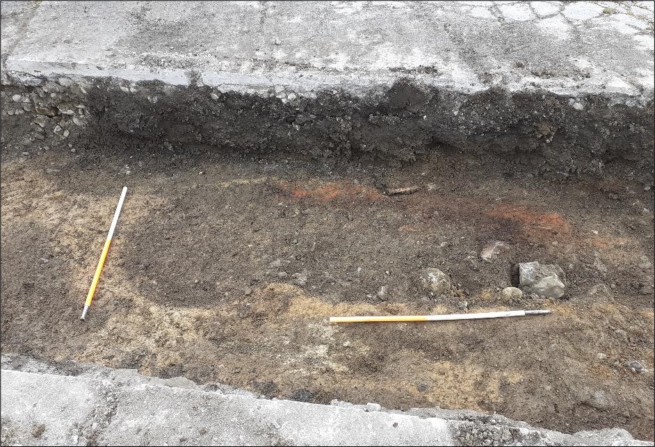
Potential archaeological activity was revealed across the central portion of the site in Trench 1 (T.1), Trench 2 (T.2) and Trench 3 (T.3). In T.1 and T.2, this appeared to comprise industrial-type backyard activity in the form of kiln- and oven-like features. These features were revealed at depths of 0.3m to 0.5m BSL. It is more likely that these features are post-medieval rather than medieval, however, only archaeological excavation can provide certainty on this.
At the southern end of T.3, a linear stone feature (possibly a collapsed wall) and undisturbed soil layers containing frequent animal bone and mollusc shell were revealed at a depth of 1.1m BSL. While the stone feature and soil layers may be associated with demesne activity from the adjacent Athenry House, an earlier origin cannot be ruled out at this point.
Similarly, a number of substantial cut features and a concentration of loose, random stones were revealed across Trench 5 (T.5), in the south-eastern margin of the site, at depths of between 1m and 1.3m BSL. While it is possible that these features are again related to post-medieval garden activity, an earlier origin cannot be ruled out due to their depth, the nature of their fills (which contained frequent animal bone and mollusc shell inclusions and no diagnostic post-medieval finds), and the fact that medieval and prehistoric activity was revealed in the adjoining site to the south and south-east. (A large-scale excavation carried out in 2007 under Ministerial Consent (C182) by Dominic Delaney and Associates, in the adjoining site to the south and south-east, uncovered archaeological activity spanning seven phases of human habitation ranging from the Neolithic, Bronze Age, early medieval, high medieval, late medieval, post-medieval and early modern periods.)
Prior to the backfilling of the excavated test trenches within the site, all features of archaeological potential were carefully covered with heavy duty polythene sheeting and marked with hazard tape.