2021:040 - GALWAY: Augustine Hill, Ceannt Station, Galway
County: Galway
Site name: GALWAY: Augustine Hill, Ceannt Station
Sites and Monuments Record No.: N/A
Licence number: 18E0651
Author: Muireann Ni Cheallachain, c/o IAC Ltd.
Author/Organisation Address: Unit G1 Network Enterprise Park, Kilcoole, Co. Wicklow
Site type: Excavation - miscellaneous
Period/Dating: Multi-period
ITM: E 530189m, N 725188m
Latitude, Longitude (decimal degrees): 53.272425, -9.046629
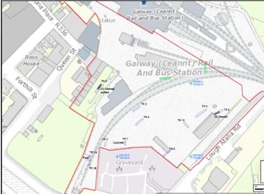
A programme of archaeological testing was undertaken as part of the proposed Augustine Hill development at Ceannt Station, Galway. This assessment has been carried out to ascertain the potential impact of the proposed development on the archaeological resource that may exist within the test area and was requested as further information by Galway County Council (Planning Ref.: 20/47). The site is located within the zone of archaeological potential for Galway town (GA094-100). There are no recorded monuments within the proposed development; however, there are four sub-constraints within a 200m radius, all scheduled for inclusion in the next revision of the RMP. The closest group consists of a graveyard, bastioned fort, and an Augustinian Friary, to the immediate south and east of the site (GA094-099001-3). Forthill Cemetery is also a protected structure and recorded on the NIAH building survey (RPS 4401; NIAH 30319007). An architectural fragment, known as the ‘Browne Doorway’, is found c. 135m to the north-west (GA094-138). The proposed development area is located on a hill that slopes down to the west and south-west. The north-western and northern wall of Forthill Cemetery (GA094-099001), which is a protected structure, borders a railway yard that extends to the northern boundary of the site. The eastern extent of the railway yard has recently been turned into a construction site compound consisting of welfare cabins, access points and areas for parking and storage of supplies. The north-west portion of the site comprises the car park for Ceannt Station and its entrance. The western extent of the site is significantly lower than the remainder of the site and is in use as a car park.
Archaeological testing was carried out over the course of five days from 4 January 2021. The trenches targeted those areas that were available within the site, which is currently in use as a construction compound. Testing revealed a cobbled surface consisting of worn angular moderate-size stone within Trench 5. The cobbles ran for 7.5m within the trench and were located 0.8m beneath the cobble lock associated with the 19th-century stable block. The extent of the cobbled surface was identified at the south–south-west end of the trench while the surface continued to the north-east outside the trench. A dark brown clayey silt was recorded sealing the cobbled surface and a number of sherds of post-medieval pottery were recovered from this fill.
A possible post-medieval occupation deposit/garden soil layer was recorded at 0.8m depth within Trench 8. The layer measured between 0.22–0.46m in thickness. It consisted of a mottled orange-brown clayey silt with occasional charcoal, animal bone and marine shell inclusions. A small sherd of post-medieval pottery was also recovered from this layer. Two fragments of dressed limestone were recovered from the waste material dumped in Trench 2. They have the same appearance as the stone used in the nearby 19th-century stables and train station buildings.
Previous archaeological investigations in 2007 and 2018, along with this archaeological testing programme, has clearly shown that there has been widespread disturbance across the proposed development area. Potential post-medieval deposits/surfaces have been identified in several of the geotechnical investigation pits and in two of the test trenches. This indicates that fragmented remains likely to date to the 18th and 19th centuries survive beneath the current ground level, but no evidence of medieval activity associated with the recorded monuments adjacent to the site has been identified.

