2022:465 - BALLYMASTONE, Donabate, Dublin
County: Dublin
Site name: BALLYMASTONE, Donabate
Sites and Monuments Record No.: N/A
Licence number: 21E0840
Author: David Bayley & Tim Coughlan, c/o IAC Archaeology Ltd
Author/Organisation Address: Unit G1 Network Enterprise Park, Kilcoole, Co. Wicklow
Site type: Burnt mound
Period/Dating: Prehistoric (12700 BC-AD 400)
ITM: E 723653m, N 749990m
Latitude, Longitude (decimal degrees): 53.485387, -6.136816
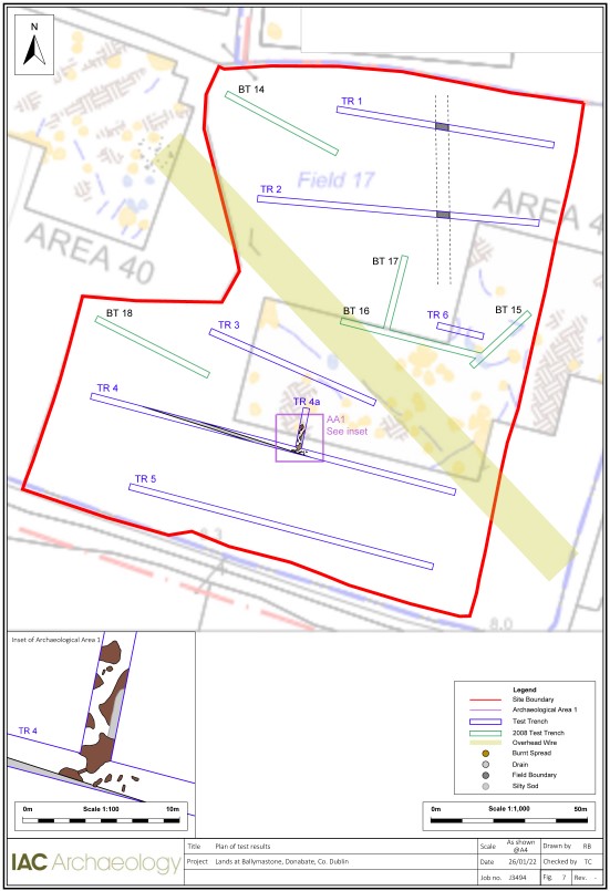
A programme of archaeological testing was carried out on 21 December 2021 at Ballymastone, Co. Dublin. A total of seven trenches were excavated across the site, measuring 465 linear metres. The trenches were laid out to target open green space, and only a single Trench (T6) targeted a curving anomaly identified in 2006 during a geophysical survey.
Whilst nothing of archaeological significance was identified within Trench 6, one area of archaeological potential, designated as Archaeological Area 1 (AA1), was discovered during the excavation of Trenches 4 and 4a, located in the south of the site.
AA1 consisted of multiple deposits of burnt mound material, possibly related to small pits or to a larger, now-dispersed, burnt mound spread. The deposits extended over an area measuring approximately 11m north-south by 5m, although the full east-west extent is likely to be larger. The more substantial deposits were located in Trench 4a and extended beyond the limits of the trench. Smaller deposits were scattered throughout the area which may represent small pit/post-hole features or residual material from a larger spread. No definitive trough or hearth was identified but is likely to survive outside the limits of the test trenches.
In addition, the line of a former field boundary ditch was identified in Trenches 1 and 2. This north-south boundary is evident on the first edition OS map 1837 and was 2m wide and 1m deep and was filled with mid-brown loamy clay.
Finally, a number of east-west orientated stone-filled field drains were evident in the western half of Trenches 3 and 4. One of these in Trench 4 truncated the southern extent of burnt mound features identified within AA1.
Investigation also clarified the stratigraphy of the area.
In general, the site was undulating and showed evidence of localised modern disturbances, possibly related to the construction of a new road to the east of the site, and associated fencing of the site along the eastern and southern boundaries.
Topsoil and overburden varied across the site, confirming modern disturbance. In the south of the site there was up to 0.35m of mixed stony beige clay overlying 0.3m original sod/topsoil which was mid-brown in colour. Similar deeper deposits are evident in the west of the site, particularly at the west end of Trench 2. Subsoil also varied across the footprint of the development. The northern half of the site consisted generally of a mottled grey-yellow-pink stony silty clay. In the south of the site which was slightly more low-lying, and at the west end of Trenches 1 and 2, subsoil consisted of a grey silty clay with yellow/orange patches. The differing subsoil across the site indicates the lower areas of the site were potentially seasonally waterlogged, which would be typical for the site type.
The identified features are characterized by spreads/deposits of heat-shattered stone in a blackened soil matrix, and are associated with burnt-mound type activity. Burnt mounds are typically found adjacent watercourses or in low-lying marginal landscapes.

