2021:614 - DUBLIN: Greenside House, 45–47 Cuffe Street, Dublin
County: Dublin
Site name: DUBLIN: Greenside House, 45–47 Cuffe Street
Sites and Monuments Record No.: N/A
Licence number: 21E0341
Author: David McIlreavy & Muireann Ní Cheallacháin, c/o IAC Archaeology Ltd.
Author/Organisation Address: Unit G1 Network Enterprise Park, Kilcoole, Co. Wicklow
Site type: Road - hollow-way, Road - road/trackway and Industrial site
Period/Dating: Multi-period
ITM: E 715594m, N 733283m
Latitude, Longitude (decimal degrees): 53.337144, -6.264307
A programme of archaeological monitoring and excavation took place at 45–47 Cuffe Street, Dublin 2 commencing on the 23rd March 2021, and was completed by the 22nd September 2021.
The preliminary report suggests that the earliest archaeological features identified during the investigation consisted of a possible holloway, later reused as the base for a well-constructed road surface. This road surface would appear to have been constructed in order to support heavy vehicular traffic, and a number of well-pronounced cart ruts were identified across its surface.
A drainage gully and two associated ditch features have been interpreted as contemporary to the road surface. The double ditch arrangement in particular is of interest as it may describe the exterior of a ravelin feature as part of the AD 17th-century city fortifications. A clay pipe bowl and stem recovered from the fill of the southernmost ditch suggests a terminus ante quem in the second quarter of the 17th century for these features.
A significant amount of leatherworking waste was identified within the upper fills of the ditch, including children’s shoe soles and a possible child’s leather jerkin. This material may indicate that a relatively specialised leather-working industry had developed outside of the former defensive feature by the second quarter of the 17th century.
The cutting of a drainage gully and an associated ditch feature, into the backfilled ditches described above, was interpreted as a renovation of the road as a transit road, although the fill material suggests that the leather industry had ceased to function by this period of use. Interestingly the recut gully in this phase partially cuts the northernmost extent of the road surface.
The next phase of development consists of a sub-rectangular rubbish pit and boundary ditch, partially cut into the backfilled ditches associated with the former cobbled roadway. The roadway itself would seem to have gone out of use at this stage, indicated by a layer of silt build-up across the surface. The boundary ditch and rubbish pit probably represent the first instance of property plot development within the development site, although the floruit of such plots may have been relatively short lived.
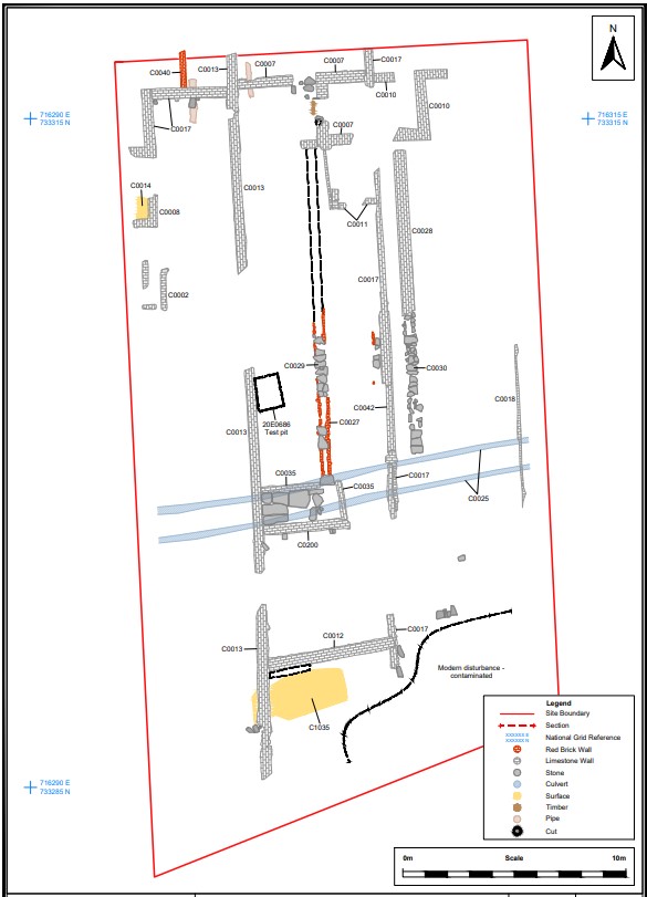
By AD 1756 a mortared stone arched culvert had been built across the development site. It is unclear if the structure was designed to canalise a pre-existing water course or was part of a new drainage system. Levelling deposits, up to 1.2m in depth towards the northern extent of the development site, were deliberately built up to surround the culvert structure, with boundary walls of new property plots built directly over these. The 1756 Rocque mapping of the area shows that housing fronting Cuffe Street and associated rear stabling have already been constructed by this time. The addition of out-housing and red brick-lined drains and possible wash pits are the only substantive changes to the layout of these plots from the initial construction. The only evidence for possible subdivision of housing interior was recorded as a sub-dividing red brick wall in the rear room of 45 Cuffe Street.
The results of the archaeological works at 45–47 Cuffe Street may be considered the remains of an early AD 17th-century roadway and associated ditches constructed as part of the fortifications surrounding Dublin. The identification of such a construction would be an extremely important addition to the post-medieval archaeological record in this area of the city; especially if further research can establish if the roadway describes the exterior of an outwork such as a ravelin.
Subsequent phases of activity, such as the possible development of a specialised leather-working industry, in the immediate area of this possible military feature, suggests its gradual absorption into an evolving industrial and suburban environment.
The tentative identification of plots predating the AD 1756 Rocque mapping is another important addition to the post-medieval record of the area, as is the suggested longevity of the front gable house plans at similar locations up to the early 19th century.
Post-excavation works are ongoing and once completed will form part of the final report that will be lodged with the National Monuments Service.

