2021:604 - BALLYKEA, THOMASTOWN AND LOUGHSHINNY, Dublin
County: Dublin
Site name: BALLYKEA, THOMASTOWN AND LOUGHSHINNY
Sites and Monuments Record No.: N/A
Licence number: 21E0087
Author: Jane Whitaker, c/o IAC Archaeology
Author/Organisation Address: Unit G1 Network Enterprise Park, Kilcoole, Co. Wicklow
Site type: No archaeology found
Period/Dating: N/A
ITM: E 725778m, N 757202m
Latitude, Longitude (decimal degrees): 53.549660, -6.101923
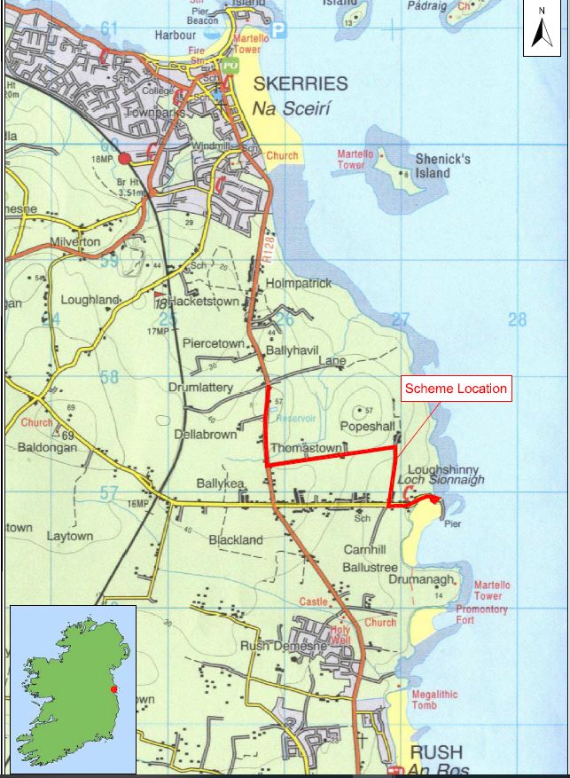
Archaeological monitoring of groundworks took place during the construction of a pumping station and associated pipeline at Loughshinny, Co. Dublin from 24 September 2020 to late March 2021.
Loughshinny beach car park is located adjacent to the beach on a slightly raised plinth while the village and harbour is overlooked by Drumanagh headland to the south. The foreshore area is a relatively level intertidal zone. Given the sheltered nature of the bay and attested prehistoric activity in the area, it was possible that finds or features such as shell middens (‘kitchen middens’) may have existed beneath the area of hard standing.
An area measuring 9m x 12m in size and 4m in depth was excavated within the confines of the car park over the course of several days prior to the shoring of the sides to facilitate the remaining excavation works. The tarmac ranged in depth from 0.07–0.12m and overlay a stone fill 0.12–0.19m in depth. In the eastern extent this stone fill overlay multiple layers of clay and rubble consisting of occasional large stones and red brick 0.73–0.8m in depth; underneath was virgin beach sand. The central area contained 0.08–0.11m of sandy clay fill underneath the tarmac with banded beach sand and sand and water rolled pebbles. In the northern extent of the excavated area the tarmac was laid directly onto beach sand 0.6m below which was coarse sand, with moderate water-rolled pebbles and occasional shell fragments to the base.
On 21 and 22 October the machine excavation of exploratory trial holes along the verge of the Mine Road was archaeologically monitored. This narrow road is bounded by fields and overgrown embankments and shallow ditches.
Pipe trench excavation commenced along the Harbour Road in late November 2020. The trenches were excavated to a depth of 1.2m with a 0.8m wide mechanical flat-bladed bucket. The pipeline was laid entirely within the existing road from the harbour to the junction of the Mine Road. Works started at the beach car park and reached the junction of Mine Road by December 17. The open trenches were inspected daily. The ground conditions along the length of this stretch remained fairly consistent and were composed of 0.15–0.22m of tarmac overlying 0.25–0.3m of stone fill which in turn overlay a mid- to pale brown friable sandy soil. In many places the trench was truncated by existing gas and watermain services.
Following the Christmas holiday period, and some delays owing to numerous services at the junction of Harbour Road and Mine Road, trench excavation works on the southern end of the Mine Road commenced on 13 January and were subject to full time archaeological supervision until 28 January when the junction with the R128 (Rush-Skerries Road) was reached. AAP2 was located along the north-south part of the Mine Road as there was potential for features or finds relating to earlier mining activity pre-dating the layout of the Mine Road to exist within the footprint of the pipeline. The pipeline trench was excavated within the grass verge rather than within the road itself along this stretch of its route. The topsoil consisted of a dark brown loamy soil varying in depth from 0.5–0.65m in depth overlying a pale brown subsoil.
Intermittent monitoring was carried out of excavation works from the junction of Mine Road and the R128 Rush-Skerries Road to the junction of Drumlattery lane where the pipeline joined with existing waste water services. The pipeline trench was excavated along the eastern extent of the road. The tarmac varied in depth from 0.4–0.5m and overlay stone fill. As the road rose to the north towards the top of Curkeen hill and the junction with Drumlattery lane the underlying subsoil was replaced with solid limestone rock.
No previously unrecorded features of archaeological potential were noted in the excavated trenches.

