2021:583 - DUBLIN: Central Mental Hospital, Dundrum Road, Dublin
County: Dublin
Site name: DUBLIN: Central Mental Hospital, Dundrum Road
Sites and Monuments Record No.: N/A
Licence number: 21E0610
Author: Marc Piera, c/o IAC Archaeology Ltd.
Author/Organisation Address: Unit G1 Network Enterprise Park, Kilcoole, Co. Wicklow
Site type: Enclosure, Hearth and Structure
Period/Dating: Multi-period
ITM: E 717168m, N 729141m
Latitude, Longitude (decimal degrees): 53.299591, -6.242214
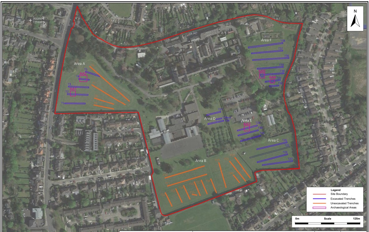
Archaeological testing was carried out over the course of five days, from 26 October 2021, targeting geophysical anomalies and open green space. A total of 21 trenches (T1–5 and T23–38) were excavated across the footprint of the development. A further 17 trenches (T6–22) which were initially proposed, were located in areas of current use for the Central Mental Hospital patients and were not excavated.
Testing revealed 5 areas of archaeological significance, which have been designated as Archaeological Areas AA1–AA5.
AA1
Two shallow linear features (C3 and C5) were identified in Trench 2. Small sherds of brown glazed pottery and red fabric pottery were observed from the fills, suggesting a post-medieval date. The identified features broadly correspond to the location of a curvilinear geophysical anomaly which was targeted in Trench 2. The plan of the geophysical anomaly indicates a penannular feature c. 4.5–5m in diameter. It may represent a small post-medieval penannular enclosure of unknown function.
AA2
Two linear features (C7 and C9) were identified in Trench 4. Sherds of pottery were observed within the fills of the features suggesting a post-medieval date. Staffordshire slipware sherds (late 17th or early 18th century in date) were identified in linear feature C9 and a tin glazed earthenware sherd pottery (18th century) was identified in linear feature C7. The features broadly correspond to the location of the rectangular geophysical anomaly which was targeted in Trench 4. The plan of the geophysical anomaly shows a rectangular structure 12m long by 9m wide. It may represent a post-medieval rectangular enclosure/building footing.
AA3
An isolated kiln (C11) was identified in Trench 29, at the north of the Area E. Remnants of scorched burnt clay were observed on the edges and base of the feature and a substantial quantity of charcoal was evident in the fill (C12).
AA4
An isolated pit (C15) was identified in Trench 33. The fill consisted of material usually associated with fulacht fiadh/burnt mound-type activity. While no associated mound was identified during testing there is a possibility of further burnt mound/fulacht fiadh remains in the vicinity of the pit.
AA5
A cluster of small possible post-holes and an area if in-situ burning, possibly a hearth, were identified in Trench 34 at the south-west of Area F. These features produced evidence of scorched burnt clay and charcoal and may indicate a localised area of burning activity.

