2021:522 - DUBLIN 15: Macetown North, Damastown Industrial Estate, Dublin
County: Dublin
Site name: DUBLIN 15: Macetown North, Damastown Industrial Estate
Sites and Monuments Record No.: N/A
Licence number: 21E0161
Author: Steve Hickey, c/o AMS
Author/Organisation Address: Fahy's Road, Kilrush, Co. Clare
Site type: Burial, Pit, Fulacht fia, Structure and Field boundary
Period/Dating: Multi-period
ITM: E 705635m, N 742300m
Latitude, Longitude (decimal degrees): 53.420228, -6.410766
This four-week excavation was carried out in May and June 2021 by a crew of five. A total of nine identified Archaeological Areas (AA) 1–9 were investigated. The excavation works followed on from a geophysical survey (licence no. 21R0040; Nicholls 2021) carried out in March 2021 and subsequent test excavations (licence no. 21E0161; Hickey 2021) in March and April 2021.
Of the nine AAs, seven corresponded with known geophysical anomalies and all sites varied in character, size, and potential significance. A selection of seven samples from these sites were sent for radiocarbon dating analysis; the returned results are included in the following AA descriptions.
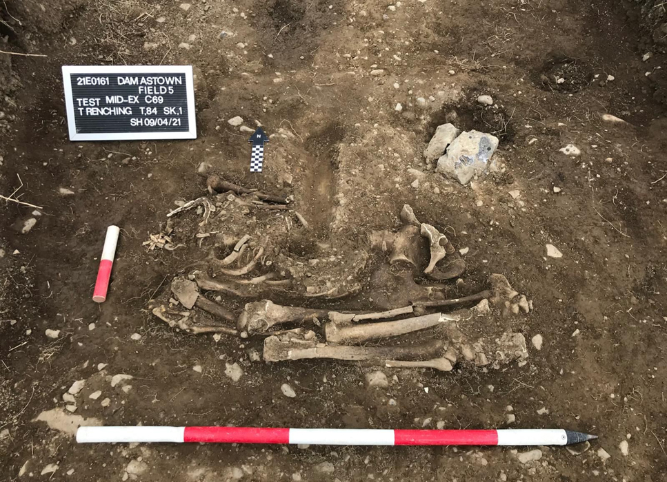
The sites comprised: a linear ditch with evidence of burning and containing prehistoric lithics (AA1), two burnt spreads and a pit (AA2), a fulacht fia of Middle Bronze Age Date (AA3, C14 date – cal BC 1536-1437), an Early Bronze Age burnt spread with associated pits (AA4, C14 date – cal BC 2880-2587), the remains of a Pre-Famine vernacular structure (AA5), four pits containing burnt material dating to the Early Bronze Age (AA6, C14 date – cal BC 2282-2030), an early medieval curvilinear feature (AA7, C14 date – cal AD 774-973), a curvilinear feature and two small pits containing evidence of burning (AA8), and an investigative area opened up around a human burial dating to the Early Bronze Age (AA9, C14 date – Cal BC 2272-2033).
The human remains (SK01) uncovered in AA9 were fully excavated and additional offset trenches were excavated to establish if the burial was part of a wider cemetery. In consultation with the NMS and NMI, monitoring took place of an area (AA9, measuring 25m x 40m) which was stripped to natural subsoil. No further archaeological features, grave cuts or human remains were uncovered, and it is considered that AA9 is fully archaeologically resolved.
The site is located at the convergence of three townlands. As per recommendations in the testing report, record photography and measured profiles of the existing boundary were undertaken at three townland boundary locations and at one field boundary location in order to retain a sample record of these heritage features within the site. At only one location within the site (a 13.5m section between Field 5 and Field 6) the townland boundary is enhanced by a north- and northwest-facing revetment set within the townland boundary ditch. The revetment wall survived in three portions and presented as roughly-hewn limestone coursed masonry not bonded by lime mortar. Due to its location within the proposed development site, preservation in situ of this wall is not possible. This masonry was fully recorded in plan, profile, and elevation drawings and was subject to a complete photographic record.
Specialist analysis of samples and finds from the site is ongoing. The results of the post-excavation analyses, which will be submitted to the licensing authorities in a final excavation report, will contribute to a better understanding of the history and role of the site and its place within a local and regional context.
The site is considered archaeologically resolved and no further mitigating works are required.

