2021:347 - KILDARE: Rathbride Road Phase 2, Dublin
County: Dublin
Site name: KILDARE: Rathbride Road Phase 2
Sites and Monuments Record No.: N/A
Licence number: 21E0261
Author: Steven McGlade, Archaeology Plan
Author/Organisation Address: 32 Fitzwilliam Place, Dublin 2
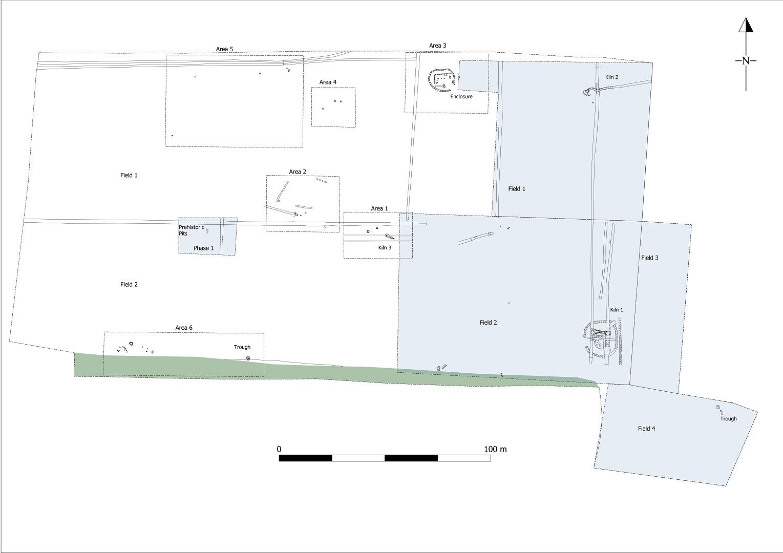
Site type: Fulacht fia, Furnace, Kiln and Enclosure
Period/Dating: Multi-period
ITM: E 673190m, N 713920m
Latitude, Longitude (decimal degrees): 53.170721, -6.905307
Archaeological monitoring and subsequent excavation was undertaken in advance of Phase 2 of the Black Millers Hill residential development in Kildare townland, north of Kildare and west of the Rathbride Road.
A previous phase of archaeological investigation carried out for Phase 1 of the development by Antoine Giacometti (Licence No. 17E0125, Excavations Ref. 2020:379) had identified a number of archaeological features including an Early Neolithic pit cluster and a fulacht fiadh trough. Two well-built kilns were also excavated, one of which lay within a circular enclosure and was associated with a possible raised granary structure.
The 2021 investigations uncovered a number of additional features to the west of the development site. A cluster of pits, two of which were prehistoric based on artefacts retrieved from them, represent the earliest activity on the site in Phase 2. One pit contained a sherd of probable Late Bronze Age pottery and a retouched scraper. The second pit contained a small convex, or thumbnail, scraper.
The trough of a fulacht fiadh measuring 1.9m by 1.6m and 0.7m in depth was also uncovered, although the associated burnt mound was absent. The trough was oval in plan and had been lined with clay. It was similar in dimensions to that excavated in Phase 1. Both troughs were uncovered along an east-west trend, part of which is defined by a townland boundary. The presence of the troughs suggests this boundary may have been defined by a stream or watercourse that survived in the landscape since the Bronze Age. There is no longer a trace of a stream in this location.
A small metalworking furnace measuring c. 0.5m in diameter and 0.2m in depth was uncovered in an isolated position near the western extent of the site. The pit had frequent inclusions of metallurgical waste and appeared to have been used for smelting rather than smithing. The furnace has not yet been dated so may relate to the later prehistoric landscape of the site, or be another component of the early medieval landcape.
A truncated cereal-drying kiln was also excavated, the third within the development as a whole. The kiln appears to have been keyhole-shaped, with a chamber to the north-west and a flue and rake-out area to the south-east. It was just under 5m in length, 1.4m in width and 0.46m in depth. The kiln was simpler than the two uncovered in Phase 1. It may represent an earlier phase of cereal processing on the site, or indicate that less effort was made with the agricultural features on the site further away from the road to the east.
A penannular enclosure that had been identified and partially investigated during Phase 1 was fully exposed for excavation during Phase 2 and the interior was found to contain a number of pits and post-holes as well as an angular slot trench suggestive of a structure. The enclosure was defined by a shallow ditch 0.57m in width and 0.16m in depth. It measured c. 11.85m in internal diameter and had an entrance measuring c. 3m to the south-east. The structure measured c. 8m by 5.5m and was orientated east-west. The southern and eastern sides were poorly defined. The slot trench defining the northern and western side was 0.58m in maximum width and 0.11m in depth. Some animal bone was retrieved from two of the adjacent pits as well as from the terminus of the enclosure ditch, however there was generally a lack of archaeological evidence that the structure and enclosure related to a permanent dwelling. Based on the similarity with the enclosure surrounding one of the kilns to the east and the spatial positioning of the kilns and enclosures across the site, it is possible the enclosure and structure formed another part of the agricultural landscape. It may be an agricultural building such as a barn, byre or a shelter for those working in the surrounding fields.
The prehistoric features uncovered during Phase 2 of Rathbride Road were not very substantial, however they can be seen as components of the larger prehistoric landscape that survives across the Curragh to the north-east.
The kilns and enclosures uncovered during both phases of the excavations at Rathbride Road suggest that there was an investment being made in the agricultural output of the site in the early medieval period. It is likely that these lands were controlled by the ecclesiastic settlement at Kildare to the south at this time. These features demonstrate the control and organisation Kildare had over its agricultural holdings.