2021:237 - BALLYCOOLEN/CLOGHRAN/GRANGE/HUNTSTOWN/KILSHANE/NEWTOWN/ST. MARGARET’S/MILLHEAD/KINGSTOWN, Dublin
County: Dublin
Site name: BALLYCOOLEN/CLOGHRAN/GRANGE/HUNTSTOWN/KILSHANE/NEWTOWN/ST. MARGARET’S/MILLHEAD/KINGSTOWN
Sites and Monuments Record No.: N/A
Licence number: 21E0090
Author: Paula Slaughter & Robert Mulraney; Shanarc Archaeology Ltd.
Author/Organisation Address: Unit 39a, Hebron Business Park, Hebron Road, Kilkenny
Site type: Excavation - miscellaneous
Period/Dating: Multi-period
ITM: E 711931m, N 742849m
Latitude, Longitude (decimal degrees): 53.423862, -6.315894
Monitoring of works relating to the upgrading of the water-mains infrastructure between Ballycoolen and Kingstown townlands, in north County Dublin was carried out between April 19 and June 15 2021.
The pipeline was laid from the eastern part of the Ballycoolin Industrial Estate and ran in a north-easterly direction, terminating at a water depot in the townland of Kingstown.
Monitoring was carried out over a distance of approximately 7km from Ballycoolen, north-east through the townlands of Cloghran, Grange, Huntstown, Kilshane, Newtown, St. Margaret’s, Millhead and Kingstown. The water main alignment ran in close proximity to ten recorded monuments/RMP sites.
During monitoring of works, a large number of field boundaries, small ditches and drains were observed and tested by digging of sections. These features were recorded but contained nothing of archaeological note.
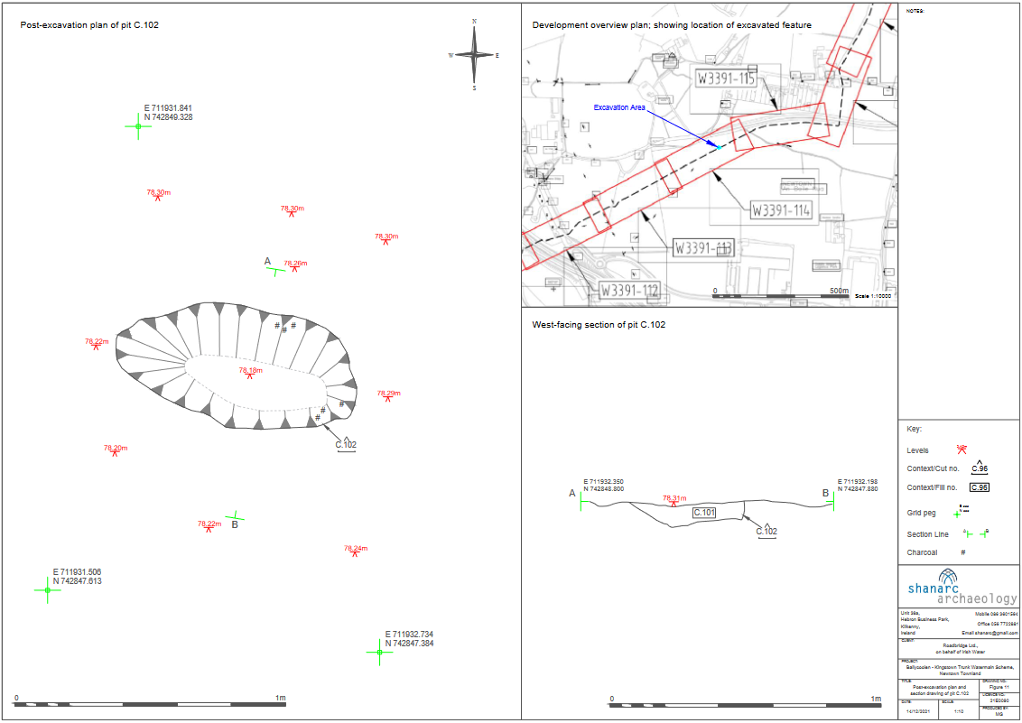
A single small pit was identified in the townland of Newtown; this feature was investigated and recorded. The pit feature contained one fill, a compact dark brown and mid-greyish orange mottled silty clay. It contained frequent charcoal flecks, occasional burnt bone, possibly human in origin, and occasional small angular stones. The pit measured 0.88m east-west by 0.43m and was 0.08m deep. It was located approximately 0.2m below surface level. Its sides were gradually sloped to the north but vertical to the south with a rounded base and an imperceptible break of slope on the base. The feature was not truncated or disturbed and cut the natural subsoil. The feature may represent the remains of an episode of burning, perhaps the sweepings of a small fire, incorporating charcoal and some bone fragments. It is unlikely that the burning took place in the immediate vicinity of the recorded feature as there was no evidence of in-situ burning. The feature contained no artefactual evidence which might aid interpretation.
A single sherd of medieval Leinster Cooking Ware was recovered in topsoil in a field to the immediate north of the recorded location of a church (DU014-012001), burial ground (DU014-012002) and holy well (DU014-012003). The recorded location of these monuments is part of an area that has been extensively quarried and no visible trace of the monuments remains.