2021:538 - CORK: 92–96 North Main Street, Cork
County: Cork
Site name: CORK: 92–96 North Main Street
Sites and Monuments Record No.: CO074-034001
Licence number: 20E0060
Author: Avril Purcell, Lane Purcell Archaeology
Author/Organisation Address: 64 Fr Mathew Rd, Turner's Cross, Cork
Site type: Historic town
Period/Dating: Multi-period
ITM: E 567004m, N 572078m
Latitude, Longitude (decimal degrees): 51.899876, -8.479464
Archaeological excavation was carried out on Nos 92 – 96 North Main Street within the historic walled, medieval town of Cork. Planning permission was granted for the construction of a strategic housing development on the site during 2020. Two upstanding buildings (Nos 92 and 95) were demolished during the initial stages of the excavation in late 2021, the rest of the site was vacant since the demolition of Nos 93 and 94, damaged by a fire in 2008. The development site lies at the western side of North Main Street and extends approximately 60m west towards Grattan Street. The town wall is outside the development site along Grattan Street.
Three trenches were excavated on the site in advance of development. Trench 1 measured 15m north-south by 12m and extended to within almost 3m of the existing street front. Trench 2 measured 8.5m east-west by 8m and was towards the south-east end of the site and Trench 3 measured 6.5m by 6.5m and was towards the centre of the western end.
The earliest phase of activity was identified in the south-eastern corner of Trench 1 where an extensive clustering of stake-holes suggested the possible partial remains of two small structures which cut a thin deposit of reclamation clay. Overlying the stake-holes the remains of part of a wattle structure and possibly the northern edge of another were identified. The remains of the structure comprised the western (rear) end of a building that fronted the street and was approximately 2.6m wide. The possible wattle structure lay immediately inside the southern edge of the trench where a line of wattle extended for approximately 1.2m in length before running into the baulk. A stone path with some overlying brushwood extended between the two (possible) wattle structures. Both the wattle structures and the earlier stake-hole structures appear to have been at the northern edge of the contemporary island and extended across the southern part of the development site (No. 93) only. The ground to the north (Nos 94 and 95) dropped away with extensive deposits of reclamation clay overlying the mud.
Above the extensive reclamation clay timber sill beams houses and property boundaries were built within the three plots, with a lane between plot Nos 93 and 94. Only the western end of the three houses was exposed with several floor levels revealed. A fourth sill beam house was partially exposed at the western end of plot No. 94. The sill beam houses were generally 3-4m wide. Large amounts of Saintonge pottery and local Cork ware were found within these houses.
The sill beam houses were overlaid by stone footings for later houses with associated clay floors surviving in places. These were of similar width to the sill beam houses except in plot 94 where the earlier lane between Nos 93 and 94 was incorporated into the footprint of the later house which was therefore wider than its neighbours, reaching approximately 5m in width. Saintonge pottery and local Cork ware were again found within these houses.
The remains of stone-built ovens were found at the rear of each of the street-fronting houses. Initial analysis suggests these were bread ovens which appear to have been built after the sill beam houses were constructed, but possibly still occupied. Several stone platforms were present within each plot which formed working surfaces probably associated with the use of the ovens. The platforms were generally of rough sandstone slabs, some shattered and broken from burning but one, within plot No. 94, was of broken fragments of querns. The associated deposits were overlaid by post-medieval material.
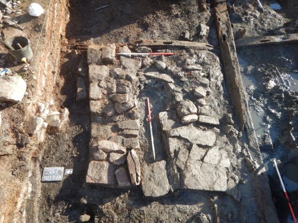
Within Trench 2 the substantial remains of a large stone building were identified; the trench was extended to reveal its full extent and the stairwell and lift shaft for the development were redesigned to accommodate the preservation in situ of the buildings remains. The building measured 13.1m north-south by 7.2m internally and 15.5m north-south by 9.4m externally. The eastern wall was not fully exposed but its position could be determined from the south-east and north-east corners. The western wall was the best preserved portion and reached a height of just over 1m with a pronounced outer batter. The wall was 0.9m to 1m wide excluding the batter. A garderobe chute was present at its southern end emptying into a stone-lined drain extending west from inside the building and a blocked door ope was present at the northern end. The northern wall had been substantially impacted by the growth of Japanese knotweed and was in poor condition. Working with an ecologist small parts of this wall were removed in order to remove the plant rhizomes from the remaining subsurface portion of the wall. The remains of the building extended across plots 94 and 95 approximately 30m from the existing North Main Street street front.
No medieval deposits were identified in Trench 3; the random rubble boundary wall between plots 94 and 95 extended across the trench (identified as Wall 4 in testing undertaken in 2019, entry 2019:360). The wall was 0.45m wide, 0.78m high and was sitting on a clay layer containing post-medieval finds, including pottery (including North Devon Sgraffito), glass and animal bone. There was no evidence of an earlier boundary feature underlying the random rubble wall suggesting the division of the western end of the site into individual properties did not occur until the 17th century in this area.
Post-excavation work is ongoing.