2021:349 - INCHIGEELAGH: Carrignacurra Castle, Cork
County: Cork
Site name: INCHIGEELAGH: Carrignacurra Castle
Sites and Monuments Record No.: CO081-017
Licence number: 20E0118; 20R0037
Author: Tony Miller
Author/Organisation Address: Tooreen
Site type: Castle - tower-house and Platform
Period/Dating: Medieval (AD 400-AD 1600)
ITM: E 523862m, N 566656m
Latitude, Longitude (decimal degrees): 51.846923, -9.105073
Excavation of a 3m-wide strip around the base of Carrignacurra Tower-house began in September 2020 following initial test excavation. This was part of an on-going project to restore the tower-house. Four trenches were excavated along the four sides of the building as well as the internal ground floor. The tower-house was constructed directly onto a ridge of bedrock which overlooks the River Lee to the north. Bedrock provides the base point in all trenches.
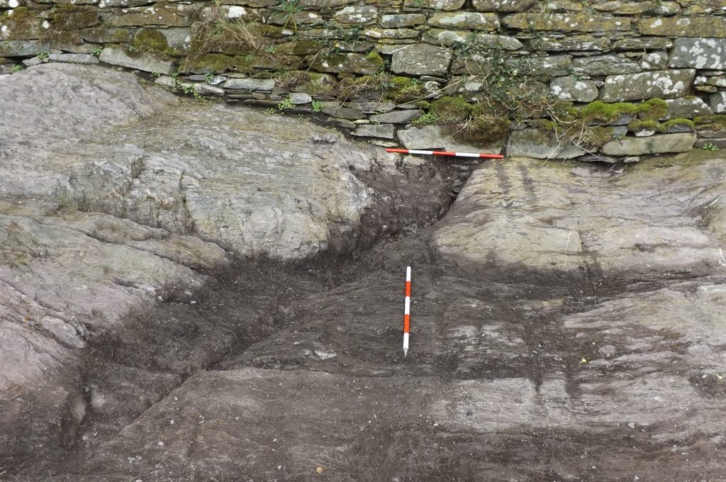
Trench 1: 12m x 3m along the western side. A general layer of mid-brown/grey topsoil mixed with gravels and sandstone chippings (C3) covered all this trench where the bedrock was not already exposed. It varied in depth between 0.1m and 0.6m at the northern end and appears to be contemporary with construction or immediately after. It overlay bedrock with two rock-cut features: a drain (C5) and a U-shaped pathway (C10). A small collection of animal bones were found in the north-west corner beneath a 2nd storey bartizan.
Trench 2: 12m x 3m along the northern side of the building. A similar general deposit was also found in this trench. It was deepest in the western end where it was divided by a thin horizon of lime mortar. Close to the bottom of this deposit a silver groat of Edward IV was found, provisionally dated to c.1470. The main rock-cut features included the garderobe basin (C26) and associated drain (C27) and two smaller drains at the eastern end (C20 & C21).
Trench 3: 16.5m x 3m along the eastern side of the building, made longer by the presence of an angle-bastion or ‘redan’ at the south-east corner. A further 3m x 3m was excavated directly in front of the entrance way. The most unusual feature of this trench was the uneven and fissured state the quarried bedrock had been left in, even where access was needed for the doorway. It would have been difficult to walk on and must have been covered with soil or possibly a timber walkway. At the northern end there was a depth of deposits with a more complex stratigraphy. These deposits appear to have come from cleaning out the ground floor and pushing the refuse down-slope to the north. Finds included a bone bead (SF20) and bone dice (SF21) with ‘dot in circle’ markings. A number of rock-cut features were also found including a single drain (C57) across the entrance opening.
Trench 4: 18m x 3m along the southern side and also including the ‘redan’. The bedrock in this trench was the highest point of the castle footprint. As in the other trenches the bedrock had been quarried and chipped away, leaving much of the south wall on a raised plinth of rock. A depth of deposits in the central area included modern demolition material as well as materials thrown out through windows from the ground and third floors. The lowest deposit (C34) appeared contemporary with construction. Finds included musket and pistol balls, small lead ingots, clay pipes and an exchequer piece or ‘jeton’ made in Nuremberg by Hans Krauwinkel c.1640.
Trench 5: 7.4m east-west x 5.5m covered the interior ground floor. The principle deposit was dried stable refuse which overlay the uneven bedrock sloping down from the west side. The bedrock was also uneven with the lower eastern side levelled with a cobbled surface (C50). A rectangular stone foundation (C53, 4.95m east-west x 0.5m) had been built against the north wall immediately adjacent to a sharpening stone fixed into the wall (C56). The lobby area had been largely restored. A modern trench was dug through the entrance exposing a section through the tower-house foundations which consisted of a shallow rock-cut trench filled with clay and chippings and covered with stone slabs. The floor of the guard room to the south of the entrance was excavated. It also contained stable refuse on top of stone slabs and bedrock. A draw-bar socket on the outside of this room indicates it could also have been used as a temporary ‘holding room’.
Monitoring of landscaping around the tower-house was also carried out. A number of potential features were recorded including a narrow pull-in area for a boat on the nearby bank of the river Lee and stone bases which were either quarry platforms or possibly bases for timber defenses along the river bank and nearby ford.
A further phase of excavation will be needed as the restoration works proceed.