2021:341 - COOLDUFF, Cork
County: Cork
Site name: COOLDUFF
Sites and Monuments Record No.: CO081-055001
Licence number: 21E0236
Author: Tony Miller
Author/Organisation Address: Tooreen, Dunmanway, Cork
Site type: Souterrain
Period/Dating: Medieval (AD 400-AD 1600)
ITM: E 539191m, N 565774m
Latitude, Longitude (decimal degrees): 51.840875, -8.882464
Pre-planning discussions required a programme of testing due to the presence of a souterrain-CO081-055001, the exact location of which was not known.
The site consisted of a rectangular field of old pasture c.2 acres in extent. It was just to the south of a local road and west of the crossroads at the top of Kilmurry village. The land sloped down to the south from close to the top of an east-west ridge.
Initial geophysics were carried out by Target (21R0046) which concluded there were ‘no clear patterns of archaeological significance’. However, there were large areas of interference, especially in the eastern half of the field beneath 3-phase lines. Eleven test trenches were excavated running north-south and 10m apart covering a total length of 450m. An average stratigraphy consisted of c.0.25m of a mid-brown loamy topsoil over brown gravels. No archaeology was found.
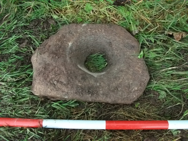
When a planning application was lodged a Further Information request required more test trenching in order to further attempt to locate the souterrain. The previous licence was extended and a further 5 test trenches were excavated east-west just in the area closest to the possible location of the monument. Test trench 2 exposed a north-south linear feature containing field stones, including a pivot stone. The linear feature was c.0.6 in depth and 1.2m wide and contained mostly topsoil indicating it was probably a filled-in drain. The pivot stone is out of context and has some more modern tooling marks on it but could originally have been used for a mill or possibly just a field gate. The linear feature was picked up in three trenches, i.e., c.20m in length before it disappeared.
In Trench 2, 10m to the east of the linear feature, the machine bucket caught the top of the souterrain chamber. Only a small hole was opened. Using a torch it was possible to see one large earth-cut chamber c.2–3m across and just under 2m in height. A single small creep-way could be seen heading to the north-west in the direction of the road. No further evidence for this souterrain was found in the test trenches to the south and the presence of bedrock indicates it was confined to the northern boundary of the site.

