2021:217 - CORK: 48, 50 & 52 Barrack Street, Cork
County: Cork
Site name: CORK: 48, 50 & 52 Barrack Street
Sites and Monuments Record No.: N/A
Licence number: 21E0361 ext.
Author: David Murphy
Author/Organisation Address: 3a Westpoint Trade Centre, Link Road, Ballincollig, Cork
Site type: Historic town
Period/Dating: Multi-period
ITM: E 567066m, N 571314m
Latitude, Longitude (decimal degrees): 51.893013, -8.478490
Following two phases of testing carried out under Excavation Licence 21E0361, a programme of archaeological excavation was carried out at the development site at Nos 48, 50 & 52 Barrack Street, Cork under an extension to the licence. Phase 2 of testing at the site had revealed that an exceptionally large ditch feature extended north-west to south-east across the south-western margin of the site. Pottery sherds potentially dating from as early as the late 12th century (Clare McCutcheon, pers. comm.) were retrieved from the mid-level fills of the ditch during the combined testing programmes.
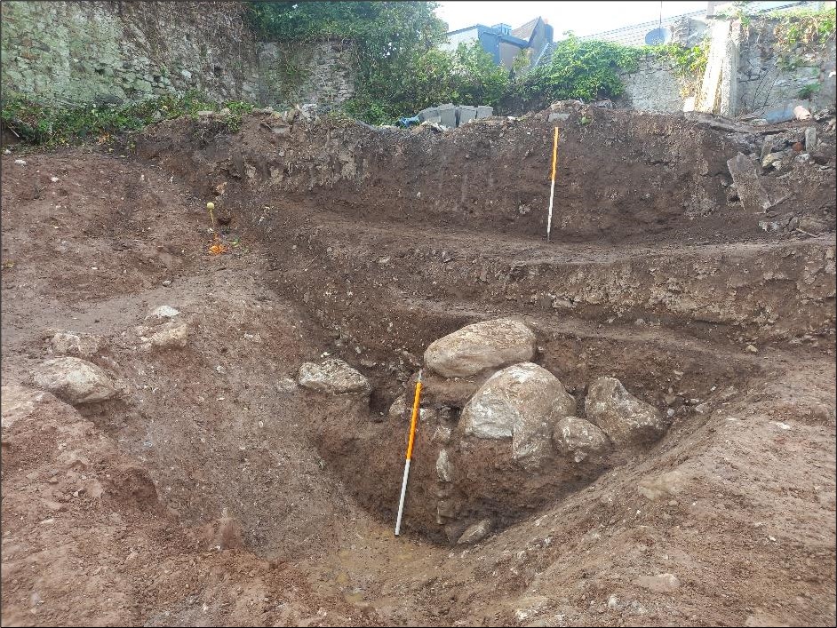
Phase 3 entailed the archaeological excavation of the fills of the ditch, in the areas which were to be impacted by construction works, down to a level 0.3m below construction formation level, as well as the full manual excavation of a 3m wide section to the base of the ditch. The remaining elements of the ditch feature beneath this level were retained in situ as part of the development. A pit feature revealed on the south-western side of the ditch cut was also excavated.
Natural subsoil was revealed at a significantly higher level to the south-west of the ditch cut (up to 1m). Ground truncation associated with modern and early modern activity appears to be responsible for the differing levels (this area was further truncated in error by the contractor between Phases 2 and 3 of the mitigation programme). Fortunately, a portion of less disturbed ground at the north-western end of the ditch, where the recorded section face was located, retained some of the levels and fills that had been truncated to the immediate south-east, east and north-east. This allowed for the completion of a detailed record of the fills and profile of the ditch.
The excavation revealed that the previously unrecorded ditch feature had been purposely backfilled at some point after it had ceased to be useful and further revealed that it measured up to 9.6m in width and 2.9m in depth (below the level of undisturbed subsoil). A section of the ditch measuring c. 24m in length (north-west to south-east) was revealed. While this comprised the full extent of the portion of the ditch within the footprint of the proposed construction location it was revealed to continue outside the north-west and south-east ends of the investigated development area. The exceptional dimensions of the feature suggest that the portion revealed within the subject site represents a short section of a previously unknown defensive ditch feature that appears to have extended through this area which formed part of the southern suburbs of the city during medieval times. Accurate dating of the feature will not be achieved until the completion of the post-excavation process, however, a number of additional sherds of probable 13th-century pottery were recovered during the excavation.
The uncovering of the exceptionally large ditch feature is a highly significant archaeological discovery not only in terms of the surrounding area but for the city in general. Post-excavation work is ongoing and from this it is hoped that an accurate date for the creation of the ditch will be gained.