2021:679 - LISCANNOR: Liscannor Waste Water Treatment Plant, Clare
County: Clare
Site name: LISCANNOR: Liscannor Waste Water Treatment Plant
Sites and Monuments Record No.: N/A
Licence number: 21E0776
Author: Kate Taylor, TVAS (Ireland) Ltd.
Author/Organisation Address: Ahish, Ballinruan, Crusheen, Co. Clare
Site type: Burnt mound and Pit
Period/Dating: Bronze Age (2200 BC-801 BC)
ITM: E 506541m, N 688809m
Latitude, Longitude (decimal degrees): 52.941935, -9.390482
During the course of earlier monitoring works on the Liscannor Waste Water Treatment Plant project (licence 21E0560) a burnt stone mound was identified towards the northern extent of the WWTP site, downslope of the primary groundworks on the edge of a river valley. Upon excavation the mound was found to overlie a wood-lined trough and a pit.
The burnt stone mound, which sealed both the trough and the pit, was irregular in shape, measured approximately 10.7m by 8.28m and was up to 0.64m thick. The mound was essentially ‘horse-shoe’ shaped in plan. Three principal deposits made up the burnt stone mound. The lower layer was found along the northern limits of the mound and comprised compact, dark brownish-grey silty clay with frequent heat-shattered stone and fine rooting. This was overlain by firm black silty clay with abundant small lumps of charcoal and heat-shattered stone. Above this, burnt mound material consisted of a moderately compact grey to black silty clay with common heat-shattered stone and occasional charcoal flecks.
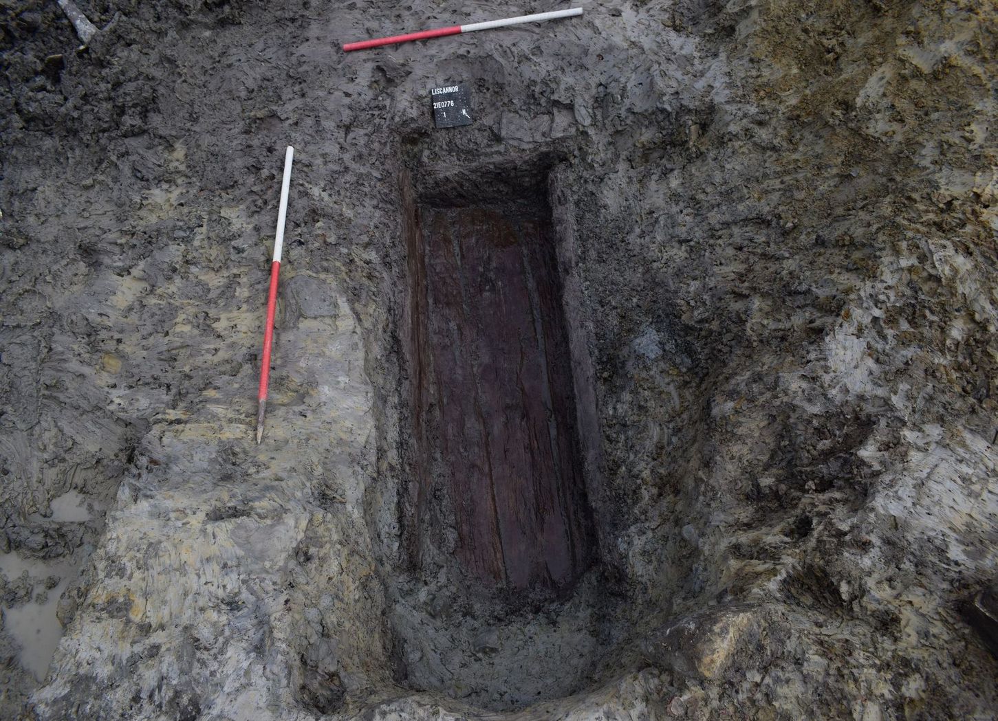
The trough was positioned almost centrally below the burnt stone mound and was set into the base of a steep natural slope. The trough was oval in plan, aligned from north-east to south-west and measured 2.32m by 1.44m, with a depth of between 0.25m and 0.5m. The break of slope at the top was rounded, with steeply-sloping sides rounding to a flat base. Slumped natural material was noted on the south-eastern side of the trough. Along the base of the cut was a 0.05m thick layer of compact mid-bluish grey silty clay with abundant inclusions of small angular stone, organic fibres, small charcoal lumps and ironized charcoal. This deposit likely formed as it washed in between the gaps of the timber lining above.
The trough was lined with thinly split planks of alder and oak along the base and sides, while a heavily charred piece of wood made up the north-eastern end piece. Eight timbers formed the trough which was essentially a rectangular wooden box, now open at its south-western side, likely due to the degradation of the end timber here. The base was horizontal and formed with axe-cut planks.
The side timber along the northern edge was also axe-cut and set against the side of the cut at an approximate 45º angle. It is likely that a vertically set timber was placed above this, however it did not survive. Slumped natural material along the southern edge of the cut dislodged and degraded the side timbers here, pushing the upper vertical timber inwards and down to the interior of the trough and degrading the side plank to the point where it was broken and fibrous.
The end timber at the north-eastern end was a piece of heavily charred branch or trunk. This charred piece of wood was supported internally by a vertically set plank at the north-east corner, while a heavily degraded fibrous piece of wood was noted on the exterior to the immediate east of the end piece. No corresponding end piece was observed at the south-western end of the trough, likely having degraded entirely. The timbers initially appeared well-preserved, but were extremely soft and fragile, except for the charred end timber, and removal proved difficult.
The trough itself was filled with several deposits. Atop the base timbers was a 0.02m-thick deposit of loose, dark brown to black sand with infrequent charcoal flecking and heat-shattered stone fragments. Over the dislodged side timber at the south was a charcoal-rich silt, no more than 0.02m thick. These deposits were then overlain by the primary trough fill, a 0.34m-thick compact pale grey silty clay with abundant heat-shattered stone and charcoal lumps. Above this, the upper fill of the trough was made up of 0.36m of firm dark grey silty clay with frequent heat-shattered stone and occasional charcoal lumps.
One of the alder trough timbers and another piece of waterlogged alder recovered from the trough fill beneath the timbers were radiocarbon dated (quoted to 2 sigma). The trough timber (deposit 59) returned a date of 1736–1536 cal. BC (UBA-49532; 3351BP ±23), the fill timber (deposit 64) a date of 1878–1643 cal BC (UBA-49531; 3443BP ±24). Together these determinations place the burnt stone mound construction and use at the end of the Early Bronze Age.
Situated 1.43m east-north-east of the trough, along the eastern extent of burnt stone mound, was a pit, measuring 0.86m by 0.8m and 0.35m deep, with a sharp break of slope at the top, steep concave side and a rounded base. The fill was a firm, but wet, yellowish-brown to black clayey silt with abundant heat-shattered stone inclusions. While the function of the pit is unknown it is likely associated with the burnt stone mound.
The features excavated and the dates from wood samples at Liscannor WWTP are consistent with a fulacht fia and an associated pit dating to the Early Bronze Age.