2020:620 - BRAY: Irishtown, Wicklow
County: Wicklow
Site name: BRAY: Irishtown
Sites and Monuments Record No.: N/A
Licence number: 20E0114
Author: David McIlreavy, c/o IAC Archaeology Ltd.
Author/Organisation Address: Unit G1 Network Enterprise Park, Kilcoole, Co. Wicklow
Site type: No archaeology found
Period/Dating: N/A
ITM: E 725968m, N 716619m
Latitude, Longitude (decimal degrees): 53.185098, -6.115220
A programme of archaeological testing was undertaken at Irishtown, Bray, County Wicklow, prior to a proposed mixed-use development. Testing followed a previous desktop assessment report carried out by Sam Fairhead of IAC Archaeology in January 2020.
The proposed development area comprises one large field partially subdivided by a former field boundary. Inspection of the aerial photographic coverage of the proposed development area revealed only superficial changes to the site in recent years. Mature trees are present along the former field boundaries visible on the 1838 and 1907-09 OS maps. An earthen bank/bund is visible from 1995 onwards in various iterations, currently running along the eastern boundary and turning west near the southern boundary, leaving a strip of land between the bank and Southern Cross Road.
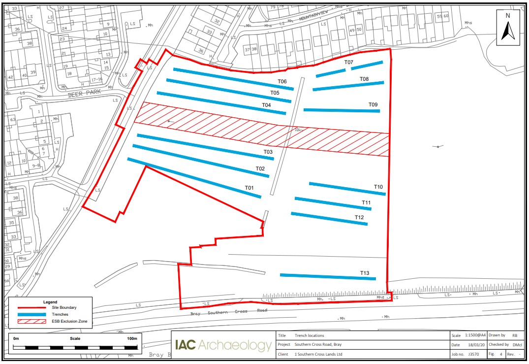
Test trenching commenced at the proposed development area on 10 March 2020 and continued for three days. A total of 13 trenches were excavated within the proposed development area, measuring 1081 linear metres in total. The layout of test trenches was designed to target open greenfield space and avoid overhead wires crossing the site as well as services along the northern edge.
The topsoil (C1) across the proposed development area consisted of a moderately compact dark brown clay with an average depth of 0.3m. The natural subsoil (C2) across the proposed development was mainly recorded as a compact light brown-orange sandy clay with frequent stone inclusions. Towards the northern extent of the site the subsoil was intermittently recorded as dark grey/black clay containing frequent decayed stone.
Across all trenches a plough soil horizon (C3) consisting of a moderately compact light orange sandy clay with infrequent stone inclusions was recorded. A number of field drains containing early 20th-century ceramic pipe sections were recorded cutting this layer. It is considered that the proposed development area was re-purposed as improved pasture during the early 20th century.
No features of archaeological significance were identified across the proposed development area.