2020:421 - ENNISKERRY: Cookstown Road, Wicklow
County: Wicklow
Site name: ENNISKERRY: Cookstown Road
Sites and Monuments Record No.: N/A
Licence number: 20E0027
Author: Muireann Ni Cheallachain, c/o IAC Ltd
Author/Organisation Address: Unit G1, Network Enterprise Park, Kilcoole, Co. Wicklow
Site type: Enclosure, Pit and Burnt mound
Period/Dating: Prehistoric (12700 BC-AD 400)
ITM: E 722593m, N 716779m
Latitude, Longitude (decimal degrees): 53.187323, -6.165628
A programme of test trenching was undertaken at Cookstown Road, Enniskerry, Co. Wicklow in advance of a proposed residential development. The assessment follows a previous desktop assessment report and a geophysical survey that was carried out across the proposed development in November 2019 (Licence 19R0234). The proposed development area consists of two arable fields, c. 6.2ha in size, located immediately east of the former demesne lands associated with Powerscourt House, in the townland of Cookstown. The western field was inaccessible at the time of testing due to the presence of a boundary comprising a mature hedgerow and bank dividing the western and eastern fields. There are no recorded monuments located within a 500m radius of the proposed development area. The closest recorded monument is an enclosure (WI007-025) located 588m to the east-north-east. A number of post-medieval finds have been found in Cookstown townland (although not within the site boundary), including a copper alloy halfpenny dating to c. 1806 (NMI Ref:1995:1979), a copper alloy plated lead mount (NMI Ref: 2003:83) and a silver token (NMI Ref: 1995:1991).
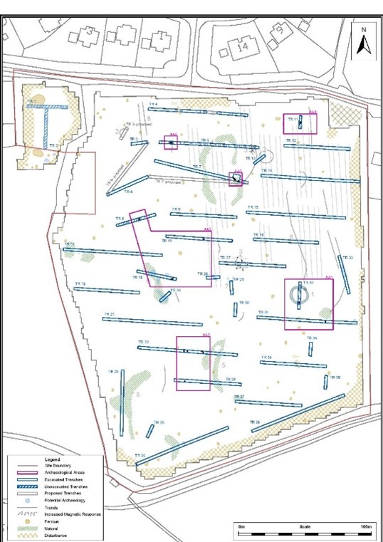
No evidence for the remains of stone pillars, as marked on the historic mapping within the proposed development area, was identified during the course of the testing and six areas of archaeology were identified across the eastern field which have been designated as Archaeological Areas (AA) 1–6.
• AA1 comprises a circular ditched enclosure of c. 14.5m diameter and an isolated pit.
• AA2 comprises nine charcoal-rich pits possibly associated with burnt mound activity.
• AA3 comprises three isolated pits.
• AA4 comprises a cluster of possible post-holes.
• AA5 comprises three charcoal-rich pits
• AA6 comprises two pits and three possible post-holes associated with prehistoric activity dating to the Neolithic period. One of the pits contained multiple sherds of Neolithic carinated bowl pottery
The archaeological features identified within AA1–6 appear to be prehistoric in date. The pottery recovered from AA6 dates to the Neolithic period while the material contained within some of the pits in AA2–5 is representative of burnt mound activity, which generally dates to the Bronze Age although Neolithic burnt mound sites have also been recorded. The circular enclosure in AA1 may represent a ring-barrow, which generally date to the Bronze Age but may also be Iron Age in date.
The area in general is a prime location for prehistoric habitation or activity due to the local topography and proximity to the Irish Sea coastline. The closest recorded excavation, located c. 1.35km north-west of the proposed development area, has shown evidence for prehistoric activity in the form of a tri-vallate ring barrow (WI007-086) and the closest recorded megalithic tomb is located c. 1.25km north-west of the proposed development area (WI007-021).