2020:560 - LUGATOBER (4), Sligo
County: Sligo
Site name: LUGATOBER (4)
Sites and Monuments Record No.: N/A
Licence number: E005259 (R00544) (also Ministerial Consent Ref. No. A079)
Author: James McKee, c/o Archaeological Management Solutions Ltd.
Author/Organisation Address: Fahy’s Road, Kilrush, Co. Clare
Site type: House - Neolithic
Period/Dating: Neolithic (4000BC-2501 BC)
ITM: E 572024m, N 841380m
Latitude, Longitude (decimal degrees): 54.320381, -8.430008
Stage (iii) Excavations were undertaken at Lugatober 4 as part of the N16 Lugatober (Drumkilsellagh to Lugnagall) Road Project, Co. Sligo. Lugatober 4 was discovered in the townland of Lugatober during Stage (i) Test Excavations undertaken in 2020 by AMS (Dowling and McKee 2020; Registration No.: E005188; Ministerial Consent Ref.: A079).
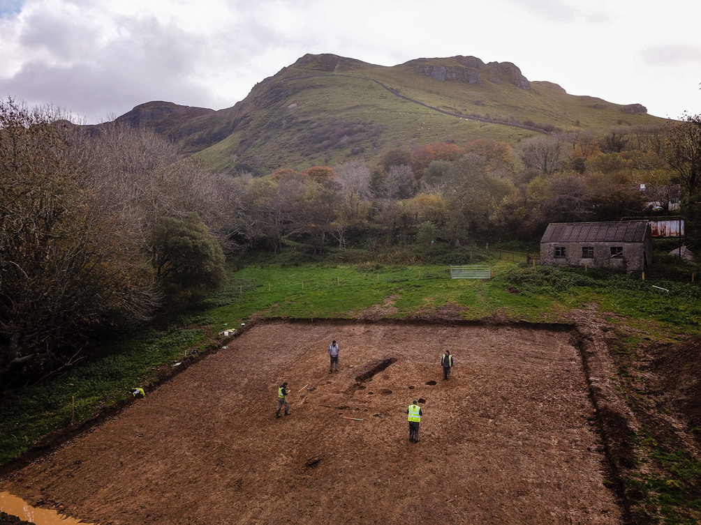
The on-site Stage (iii) Excavation Services at Lugatober 4 were undertaken between 19 and 23 October 2020. The site consisted of shallow slot-trenches, post-holes and pits found on a gentle north-west-facing slope at the base of Cope’s Mountain. The rectangular plan of the structure and the nature of the associated finds suggest this to be an Early Neolithic two-roomed house measuring c.3.4m wide and 6.3m long and orientated north-east to south-west. A hazel charcoal sample from one of the wall slots provided a radiocarbon date of 3756–3636 cal. BC. Structured deposition was a characteristic of the site especially at the north-eastern gable wall foundation. Finds included Early Neolithic pottery, rubbing stones and flint tools, including a plano-convex knife, scrapers and blades. Two stone beads and a quartz core were also found. Clay wasters were recovered, suggesting that pottery was fired in the vicinity of the site. Frequent charcoal was noted in the features, raising the possibility that the structure had been burnt.
Lugatober 4 is one of a number of potential prehistoric sites identified in this locality as part of the N16 Road Project. These include a series of pits and other small discrete features at the site of Lugatober 5, about 50m to the north, and several pits and possible charcoal-production pits at Collinsford 1, some 200m to the northeast.
Reference
Dowling, G. & McKee, J. 2020. N16 Lugatober (Drumkilsellagh to Lugnagall) Road Project Stage (i)a Test Excavation, Stage (i)f Townland Boundary Surveys and Stage (i)g Topographical Survey Report. Ministerial Consent Ref.: A079; Registration Nos.:
E005188. Unpublished report by Archaeological Management Solutions Ltd on behalf of Sligo County Council.