2020:732 - LURGAN (3), Roscommon
County: Roscommon
Site name: LURGAN (3)
Sites and Monuments Record No.: N/A
Licence number: E5131
Author: Joe Nunan, Saoirse Bailey and Paul Stevens, AMS
Author/Organisation Address: Fahy's Road, Kilrush, Clare
Site type: Ringfort - rath, Souterrain, Kiln and Burial
Period/Dating: Early Medieval (AD 400-AD 1099)
ITM: E 587314m, N 786138m
Latitude, Longitude (decimal degrees): 53.824598, -8.192681
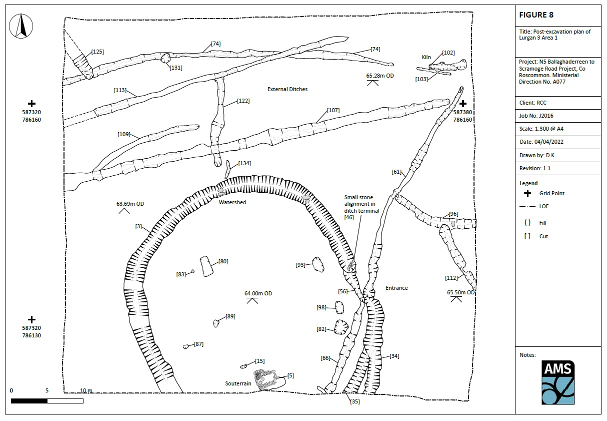
Lurgan 3 was excavated in advance of construction of the N5 Ballaghaderreen to Scramoge Road Project in County Roscommon by Archaeological Management Solutions (AMS) for Roscommon County Council (RCC) and Transport Infrastructure Ireland (TII). The site consisted of a univallate ringfort-rath, associated stone-lined souterrain, pits, drainage ditches and four stone-lined and unlined cereal-drying kilns, located in two areas on the western slope of a hill within an undulating low-lying field.
It was identified during geophysical survey (Nicholls 2019) and later confirmed during Stage (i)a Test Excavations, carried out by AMS under Ministerial Direction (Direction No. A077, Registration No. E5070) (Hardy 2021).
Excavation in Area 1 revealed an early medieval ringfort or rath that consisted of an enclosure with entrance to the east, internal stone-lined souterrain and several pits, a kiln and curvilinear ditches, with two inhumations and several early medieval domestic artefacts and pottery. The enclosure ditch covered an area c.36.5m (east–west) by c.30m+ that continued south outside the limit of excavation. Two crouched inhumations burials and a dog were interred in interior and external features, late in the life cycle of the enclosure.
Area 2 revealed a cluster of three stone-lined and unlined cereal-drying kilns and two linear ditches, one of which geophysical evidence revealed to be continuation of a large curvilinear ditch in the northern quadrant of Area 1. A third inhumation burial was also revealed, inserted into one of the later kilns.
Finds recovered from the site included a silver brooch, a copper-alloy bracelet and mount, two coloured glass beads, a jet-like bracelet, a bone pin, needle and socketed object. Ceramics recovered comprised early medieval pottery sherds, post-medieval pottery sherds and a clay tobacco pipe bowl. Other objects included two spindle whorls (stone and bone), a stone rotary quern and three whetstones, 25 ferrous objects, plus eleven chert or flint lithics. Bulk soil samples were retrieved from the site, together with bone samples, metallurgical and burnt clay/daub samples, for subsequent environmental and industrial analysis and radiocarbon dating.
Post-excavation works for Lurgan 3 will include environmental, artefactual, metallurgical and in-depth historical research with the aim of further placing the ringfort in its broader context.
This preliminary report summary was submitted on behalf of its authors.
References
Hardy, C. 2021. N5 Ballaghaderreen to Scramoge Road Project Stage (i)a, (i)b, (i)c Test Excavation, Stage (i)m Testing in Felled Forestry and Stage (i)f Townland Boundary Survey. Ministerial Direction No. A077, Registration No. E5070. Unpublished AMS report for TII and RCC.
Nicholls, J. 2019. Geophysical Survey Report, N5 Ballaghaderreen to Scramoge Road Project, Co. Roscommon. Unpublished report prepared by Target Archaeological Geophysics Ltd on behalf of Archaeological Management Solutions.