2020:733 - CARTRONAGOR (5), Roscommon
County: Roscommon
Site name: CARTRONAGOR (5)
Sites and Monuments Record No.: N/A
Licence number: E5218
Author: Joe Nunan, Alan Healy and Conn Herriott, AMS
Author/Organisation Address: Fahy's Road, Kilrush, Clare
Site type: Burnt mound
Period/Dating: Prehistoric (12700 BC-AD 400)
ITM: E 582686m, N 787653m
Latitude, Longitude (decimal degrees): 53.838078, -8.263058
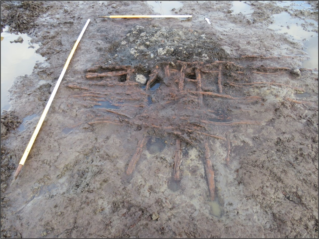
Cartronagor 5 was excavated in advance of construction of the N5 Ballaghaderreen to Scramoge Road Project in County Roscommon by Archaeological Management Solutions (AMS) for Roscommon County Council and Transport Infrastructure Ireland. The site was identified during Stage (i)a Test Excavations, carried out by AMS under Ministerial Direction (Direction No. A077, Registration No. E5070; Hardy 2021). The archaeological remains at Cartronagor 5 contained three main areas of activity which comprised a burnt spread and two burnt mounds overlying a timber-lined trough, several other pits (possible troughs), timber/brushwood platforms, a possible hearth and associated features. Running through the site was a palaeo-channel.
The on-site Stage (iii) Excavation Services at Cartronagor 5 were undertaken by AMS between 14 September and 21 October 2020.
Area 1: A burnt mound measuring 9.06m long, c.5m wide, 0.14m deep overlay a pit 1.46m long, 1.26m wide, 0.08m deep, associated with a timber plank platform/layer and a brushwood platform/layer. A wood (ash) sample from the brushwood layer returned a Chalcolithic period date: 2474–2297 cal. BC (UBA-48766, 3924±26BP). The burnt mound also covered another pit 1.94m long, 1.57m wide, 0.13m deep, overlaid by a possible hurdle panel. A wood (ash) sample from this possible hurdle panel returned a Late Neolithic to Chalcolithic date: 2853–2497 cal. BC (UBA-48768, 4085±27BP).
Area 2: A burnt mound measuring c.8m long, c.4m wide, 0.12m deep overlay a possible hearth, two stone deposits, a rectangular pit 2.66m long, 2.3m wide, 0.2m deep and another pit 1–1.1m long, 1m wide, 0.1m deep with a timber platform/lining. An alder sample from this platform/lining returned a Late Neolithic to Chalcolithic date: 2554–2301 cal. BC (UBA-48769, 3929±24BP).
Area 3: A burnt spread measuring c.8m long, c.5.6m wide, 0.14m deep overlay an earth-cut trough 1.7m long, 0.6m wide, 0.15m deep with a timber lining and archaeological upcast. An oak sample from the trough lining returned a Chalcolithic to Early Bronze Age date: 2139–1959 cal. BC (UBA-48767, 3672±26BP).
One artefact was found during the investigations: a piece of iron—either naturally occurring or possibly slag/ore—was recovered from a sample of the burnt mound material in Area 1. A limited animal bone assemblage from the site represented the remains of at least two cattle and one pig. The presence of bones of high meat value indicates that the cattle were slaughtered locally prior to being butchered for meat. Charred wood macro-remains from the troughs, pits and stakeholes consisted of alder, hazel, ash, oak, willow and pomaceous fruitwood, as well as birch, holly, poplar and blackthorn/cherry. Archaeobotanical remains included waterlogged seeds and capsules of brambles, clover, possible sedges and bryophytes. The insect remains from Cartronagor 5 were identified as species which occupy a wide range of environmental niches.
This final report summary was submitted on behalf of its authors.
References
Hardy, C. 2021. N5 Ballaghaderreen to Scramoge Road Project Stage (i)a, (i)b, (i)c Test Excavation, Stage (i)m Testing in Felled Forestry and Stage (i)f Townland Boundary Survey. Ministerial Direction No. A077, Registration No. E5070. Unpublished AMS report for Roscommon County Council and Transport Infrastructure Ireland.