2020:728 - KILLEEN EAST (4), Roscommon
County: Roscommon
Site name: KILLEEN EAST (4)
Sites and Monuments Record No.: N/A
Licence number: E5119
Author: Joe Nunan, Saoirse Bailey and Kevin Kearney, AMS
Author/Organisation Address: Fahy's Road, Kilrush, Clare
Site type: Burnt mound
Period/Dating: Bronze Age (2200 BC-801 BC)
ITM: E 588520m, N 786189m
Latitude, Longitude (decimal degrees): 53.825084, -8.174366
Killeen East 4 was excavated in advance of construction of the N5 Ballaghaderreen to Scramoge Road Project in County Roscommon by Archaeological Management Solutions (AMS) for Roscommon County Council (RCC) and Transport Infrastructure Ireland (TII). The site consisted of a burnt mound and associated features located in a low-lying field of pasture, c.300m north of Clooncullaun Lough. It was identified during Stage (i)a Test Excavations carried out by AMS (Ministerial Direction No. A077, Registration No. E5070; Hardy 2021).
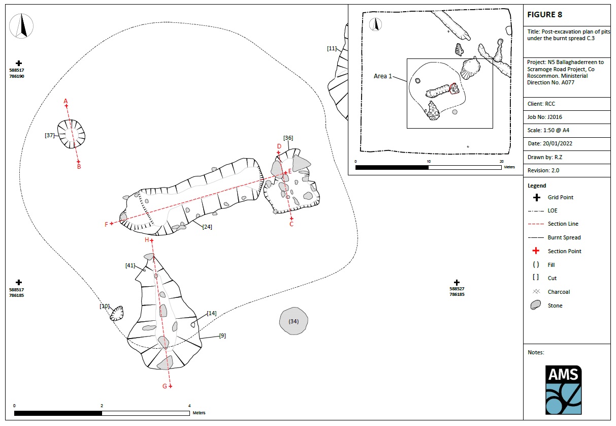
The sub-circular burnt mound (C.3) comprised a layer of moderately compact, charcoal-rich silty clay and frequent heat-shattered stone measuring 7.35m east to west by 7m and 0.27m deep; its north-east area was overlaid by a shallow layer of peat. Underlying the mound was a rectangular trough (4.9m by 0.43m in plan and 0.43m deep), and a pit (3.4m by 1.8m in plan and 0.18m deep) with two circular stake-holes cut into its base. A shallow pit (0.5m by 0.4m in plan and 0.07m deep) was underlying the north-west area of the burnt mound. A midshaft lateral portion of a cow metacarpus was recovered from the basal fill of the trough, while organic residue (lipid) analysis from a sample of stone from the fill of the larger pit suggests the presence of vegetation-derived organic matter of a woody origin, possibly roots found in soil.
Adjacent to the mound were two pits and two post-holes. The first pit (3.4m by 2.3m in plan and 0.3m deep) had a circular stake-hole at its base and both features were infilled with the same material. A sample of hazel charcoal from the basal fill of the pit returned a Middle Bronze Age date of 1686–1515 cal. BC (UBA-47772; 3325±29BP), while two cow skull fragments, three pieces of bone from a large-sized animal, probably cow, and nine indeterminate specimens were recovered from its upper fill.
The second pit (2m by 1.13m in plan and 0.6m deep) also contained a stake-hole at its base which was infilled with the lower fill of the pit. The lower fill contained moderate roots and wood fragments; however, it appeared irregular and likely represented tree-rooting activity rather than a pit lining.
Lying just southeast of the burnt mound and in close proximity to the pits was a large oval stone of whitish-grey limestone that was embedded into the subsoil (0.77m by 0.55m in plan and was 0.14m thick). It exhibited possible cutmarks on its flat, upper surface suggesting its possible use as a butchery stone. A grey clay spread partially overlaid the stone as well as the south-east area of the burnt mound. A worn molar from an adult cow, along with pieces of long bone from a medium-sized animal and seven indeterminate fragments, were recovered from within this clay layer.
Three post-medieval ditches associated with a field boundary marked on the first-edition six-inch OS map (1838) were also recorded in the north-east corner of the excavation area.
No finds were recovered. Charcoal remains comprised alder, hazel, ash, oak, elm and pomaceous fruitwood, while non-wood macro remains consisted of hedgerow species, including brambles (Rubus sp.), docks (Rumex sp.) and mustards (Brassica sp.).
This report summary was submitted on behalf of its authors.
Reference
Hardy, C. 2021. N5 Ballaghaderreen to Scramoge Road Project Stage (i)a, (i)b, (i)c Test Excavation, Stage (i)m Testing in Felled Forestry and Stage (i)f Townland Boundary Survey. Ministerial Direction No. A077, Registration No. E5070. Unpublished AMS report for TII and RCC.