2020:729 - LURGAN (4), Roscommon
County: Roscommon
Site name: LURGAN (4)
Sites and Monuments Record No.: N/A
Licence number: E5190
Author: Joe Nunan and Brigid Melloy, AMS
Author/Organisation Address: Fahy's Road, Kilrush, Clare
Site type: Structure
Period/Dating: Modern (AD 1750-AD 2000)
ITM: E 587121m, N 785932m
Latitude, Longitude (decimal degrees): 53.822742, -8.195604
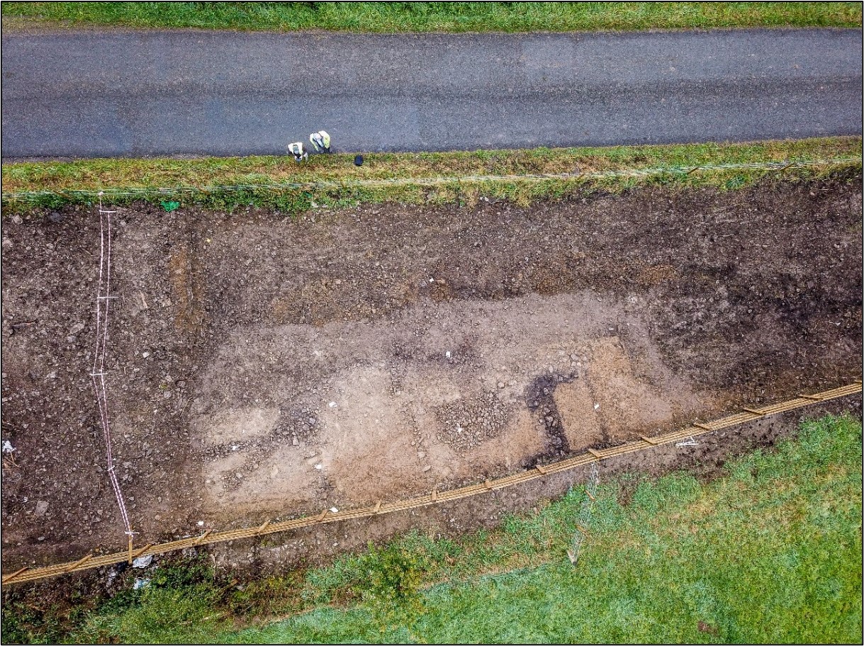
Lurgan 4 was excavated in advance of construction of the N5 Ballaghaderreen to Scramoge Road Project in County Roscommon by Archaeological Management Solutions (AMS) for Roscommon County Council (RCC) and Transport Infrastructure Ireland (TII).
The site was indicated on two editions of the 25-inch Ordnance Survey (OS) map (1892 and 1914) and consisted of a vernacular structure and collapsed structure. It was identified during Stage (i)a Standard Test Excavations, carried out by AMS under Ministerial Direction (Direction No. A077, Registration No. E5070) (Hardy 2021).
The vernacular structure was located at the northern extent of the site and comprised an L-shaped arrangement of two walls orientated north–south (C.3) and east–west (C.4). Externally the structure measured 4.6m by 3m and internally it measured 3.9m by 2.5m with no evidence for internal divisions, doors, fireplaces or other such features. The foundation cut for the structure was overlain by stone walls which comprised a single row of uncoursed, roughly hewn, small- to medium-sized rounded and sub-angular limestones mixed with occasional mid-greyish brown silty clay. The structure was cut by a drain which also cut a linear drain. This unexcavated drain was cut by a foundation cut overlain by a wall which comprised moderately compacted uncoursed and unhewn medium- to large-sized rounded and sub-angular limestone with light greyish-brown silty clay. At the southern extent of the site, a drain, a wall and a layer of mortar in addition to a wall were likely components of a collapsed structure associated with stony surfaces.
According to historical sources, the structure was inhabited by the McGrath family in the early twentieth century. Local information indicates the structure served as a shop, and in the 1911 census, son Michael McGrath was listed as a shop assistant, supporting this information. A single metal find (an iron axehead) was retrieved from the overlying topsoil and is likely associated with the structure. It has been examined by a specialist and determined to be post-medieval in form and similar to the Type 1 medieval axe (a woodman’s axe) and would have served many functions for the McGrath family.
This report summary was submitted on behalf of its authors.
References
Hardy, C. 2021. N5 Ballaghaderreen to Scramoge Road Project Stage (i)a, (i)b, (i)c Test Excavation, Stage (i)m Testing in Felled Forestry and Stage (i)f Townland Boundary Survey. Ministerial Direction No. A077, Registration No. E5070. Unpublished AMS report for TII and RCC.
National Archives of Ireland. 2012. Census of Ireland 1901/1911. [Accessed: 3 June 2022]. Available from: http://www.census.nationalarchives.ie/reels/nai003234811/