2020:730 - RAHEEN (1), Roscommon
County: Roscommon
Site name: RAHEEN (1)
Sites and Monuments Record No.: N/A
Licence number: E5219
Author: Joe Nunan and Brigid Melloy, AMS
Author/Organisation Address: Fahy's Road, Kilrush, Clare
Site type: Structure
Period/Dating: Modern (AD 1750-AD 2000)
ITM: E 582645m, N 787655m
Latitude, Longitude (decimal degrees): 53.838095, -8.263681
Raheen 1 was excavated in advance of construction of the N5 Ballaghaderreen to Scramoge Road Project in County Roscommon by Archaeological Management Solutions (AMS) for Roscommon County Council (RCC) and Transport Infrastructure Ireland (TII).
The site consisted of partial structural foundations. It was identified during Stage (i)m Test Excavations, carried out by AMS under Ministerial Direction (Direction No. A077, Registration No. E5070) (Hardy 2021).
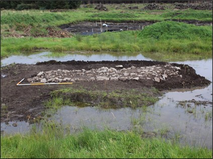
The site comprised a stone platform orientated north-north-west/south-south-east. It was trapezoidal in plan with a semi-elliptical northern edge. The structure measured c.6.2m long, 2–2.9m wide and 0.15–0.28m deep and contained three fills (C.5, C.3, C.6), set into a foundation cut (C.4). The basal fill (C.5) comprised moderately compacted medium to large sized limestone blocks and light greyish-brown silty clay 0.15–0.28m. This was overlain by moderately compacted limestone rubble, occasional sandstone, pea and stream gravel 0.15–0.28m deep (C3). The upper fill (C.6) comprised loosely compacted small stones and light grey silt and gravel, 0.15–0.28m deep, likely used to level and harden the surface of the structure.
Two sherds of pottery (E5219:1 & E5219:2) were found in topsoil (C.1) and subsoil (C.2), and a glass shard (E5219:3) was found in fill C.3. These were analysed and dated to the eighteenth–twentieth centuries.
The remains at Raheen 1 may be associated with a structure indicated on the first-edition six-inch OS map (1838), possibly as a small agricultural feature such as the base of a hay rick. Griffiths’ Valuation (1857–58) listed John Irwin as the land holder. No direct connection can be made with certainty between the families listed in the 1901/1911 censuses and the remains at Raheen 1. However, as the associated structure does not appear on the 25-inch OS map (1914), it was likely abandoned in the post-Famine period.
This report summary was submitted on behalf of its authors.
References
Ask About Ireland. 2003. Griffith’s Valuation. [Online]. [Accessed: 3 June 2022]. Available from: https://www.askaboutireland.ie/griffith-valuation/
Hardy, C. 2021. N5 Ballaghaderreen to Scramoge Road Project Stage (i)a, (i)b, (i)c Test Excavation, Stage (i)m Testing in Felled Forestry and Stage (i)f Townland Boundary Survey. Ministerial Direction No. A077, Registration No. E5070. Unpublished AMS report for TII and RCC.
National Archives of Ireland. 2012. Census of Ireland 1901/1911. [Online]. [Accessed: 3 June 2022]. Available from: http://www.census.nationalarchives.ie/