2020:800 - CASHEL (4), Roscommon
County: Roscommon
Site name: CASHEL (4)
Sites and Monuments Record No.: N/A
Licence number: A077 E5167
Author: Eve Campbell, Archaeological Management Solutions
Author/Organisation Address: Fahy's Road, Kilrush, Co. Clare
Site type: House - 19th/20th century
Period/Dating: Modern (AD 1750-AD 2000)
ITM: E 574680m, N 788832m
Latitude, Longitude (decimal degrees): 53.848344, -8.384791
Cashel 4 was excavated in advance of construction of the N5 Ballaghaderreen to Scramoge Road Project in County Roscommon by Archaeological Management Solutions (AMS) for Roscommon County Council (RCC) and Transport Infrastructure Ireland (TII).
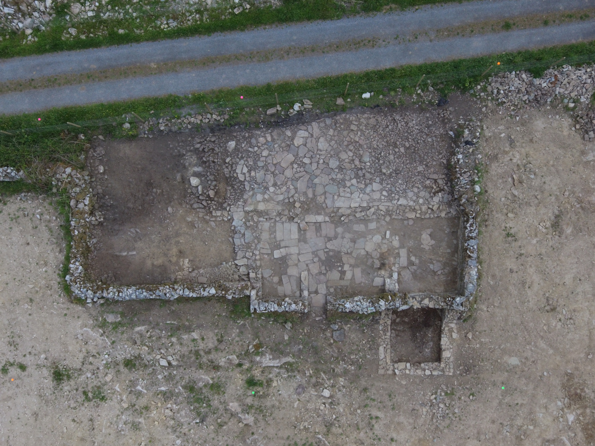
Cashel 4 consisted of the remains of a rectangular direct-entry three-room vernacular dwelling with two appended outbuildings and a paved yard. The site was located in the south-east corner of a narrow pasture field fronting onto a minor road that formed the boundary of the former Hermitage Estate and eastern boundary of Cashel townland. Cashel 4 (CHC 17) was initially recorded in the Environmental Impact Assessment Report (Roughan & O’Donovan 2017, chapter 14, 69) as the location of a building marked on the first-edition six-inch OS map (1838); it is also shown on the 25-inch OS map (1914). It was noted in LiDAR analysis (Davis 2015, 11, 50) as the site of a rectangular platform (18.1/AH11).
Prior to excavation the building was legible only as a heavily overgrown mound of rubble in a plot of ground flanking a minor road to the east. The site was further investigated during testing. Cashel 4 was located in testing Area 97. Testing was carried out in this area between 29 August and 2 September 2019 (Hardy 2021). At Cashel 4 the proposed test trenches could not be excavated due to the presence of upstanding features. The testing methodology was adapted on site and the general area of the former cottage was uncovered mechanically and cleaned back to reveal traces of a flagstone floor and an exterior yard. The development will remove all trace of the dwelling identified at Cashel 4.
The site of Cashel 4 consisted of a nineteenth–twentieth-century vernacular complex consisting of a dwelling (Structure 1) with two attached outbuildings (Structure 2 and Structure 3). Structure 1 was rectangular in plan with overall dimensions of 11.9m by 5.35m north–south. The building had a pair of opposed doorways located in the northern third of the east and west walls. A single hearth was present in an internal hearth wall in the southern third of the building. A second internal wall was found in the northern third of the building. The southernmost room (Room 1) was 3.16m north–south by 4m; the central room (Room 2 – kitchen) was 4.1m north–south by 4m; and the northernmost room (Room 3) was 2.1m north–south by 4.05m. Structure 2 comprised a rectangular outbuilding with a cobbled floor located immediately north of and abutting Structure 1. The front of the building was flush with the main dwelling. It was 4.25m by 3.84m east–west (externally), with internal dimensions of 3.3m by 2.6m. A third rectangular building (Structure 3) was found abutting the western wall of Structure 1. The building had overall dimensions of 3.9m by 3.7m north–south and was 3.1m by 2.65m east–west internally.
A significant quantity of post-medieval pottery, clay pipes, glass and metal was retrieved during the excavation, in addition to a small quantity of animal bone. Most of the finds were broadly dated to the nineteenth–twentieth centuries and suggest an active household that engaged in a variety of domestic and agricultural activities and were cognisant of societal trends and fashions. Artefacts recovered from the site included a wealth of pottery and glass used for food preparation and storage and for display in the home, metal tools and equipment for use both inside and outside the home, fragments from clay tobacco pipes and items of a more personal nature such as a bone toothbrush. Historical evidence suggests that the dwelling was occupied by Thomas Moran in the mid-nineteenth century, according to Griffith’s Valuation (1857–58), and then by Edward Gaffrey (45), a gamekeeper, as recorded by the 1901 census. Pieces from the artefact assemblage indicate the presence of women and children, suggesting that Gaffrey married later in life. The dwelling appears to have been occupied until the mid-twentieth century. A selection of the material recovered from the excavation has been recommended for photography, illustration and/or retention. It is intended, subject to the approval of the NMI, to dispose of the remainder of the material.
References
Davis, S. 2015. N5 Strokestown-Ballaghaderreen corridor: LiDAR Assessment. Unpublished report prepared by UCD School of Archaeology for RCC and TII.
Hardy, C. 2021. N5 Ballaghaderreen to Scramoge Road Project Stage (i)a, (i)b, (i)c Test Excavation, Stage (i)m Testing in Felled Forestry and Stage (i)f Townland Boundary Survey. Ministerial Direction No. A077, Registration No. E5070. Unpublished AMS report for TII and RCC.
Roughan & O’Donovan/AECOM. 2017. N5 Ballaghaderreen to Scramoge Road Project Environmental Impact Assessment Report. TII and Roscommon National Road Design Office.