2020:771 - CLOONYEFFER (3), Roscommon
County: Roscommon
Site name: CLOONYEFFER (3)
Sites and Monuments Record No.: N/A
Licence number: Registration No. E5193, Ministerial Direction No. A077
Author: John Channing, c/o Archaeological Management Solutions Ltd.
Author/Organisation Address: Fahy’s Road, Kilrush, Co. Clare
Site type: Pit and Cultivation ridges
Period/Dating: Multi-period
ITM: E 581781m, N 787548m
Latitude, Longitude (decimal degrees): 53.837104, -8.276802
Cloonyeffer 3 was excavated in advance of construction of the N5 Ballaghaderreen to Scramoge Road Project in County Roscommon by Archaeological Management Solutions (AMS) for Roscommon County Council (RCC) and Transport Infrastructure Ireland (TII). The subsurface remains of pits and furrows were identified at Cloonyeffer 3 during Stage (i)a Standard Test Excavations, carried out by AMS under Ministerial Direction (Direction No. A077, Registration No. E5070; Hardy 2021).
Area A comprised a single pit truncated by a cultivation furrow. This pit was sub-oval in plan, 0.85m long, 0.75m wide, 0.27m deep and contained three fills. The basal fill comprised a firmly compacted yellow-brown clayey sand with occasional flecks of charcoal and small stone inclusions. The middle fill comprised a firmly compacted dark-brownish black silty sand with occasional small stones including frequent quartz, frequent charcoal flecks and charcoal staining. The upper fill comprised a mottled mid-grey-brown silty sand with occasional charcoal flecks and small stones. Charcoal from the middle fill consisted of primarily of oak, with hazel and birch also identified and a sample of birch charcoal returned an Early Neolithic date of 3953–3714 cal. BC (UBA-47774; 5044±33BP). Two indeterminate fragments of burnt animal bone, fourteen chert flakes, a chert bipolar core, chert debitage, a quartz bipolar core, five quartz and rock crystal flakes and two quartz and rock crystal blades were recovered from the middle fill of this pit.
A series of furrows was present in Area A and Area B with a northeast–southwest and northwest–southeast alignment. The furrows were an average of 0.3m wide, 0.5m deep and spaced 0.5–0.8m apart. They contained a uniform fill of loosely compacted mid-brown silty clay.
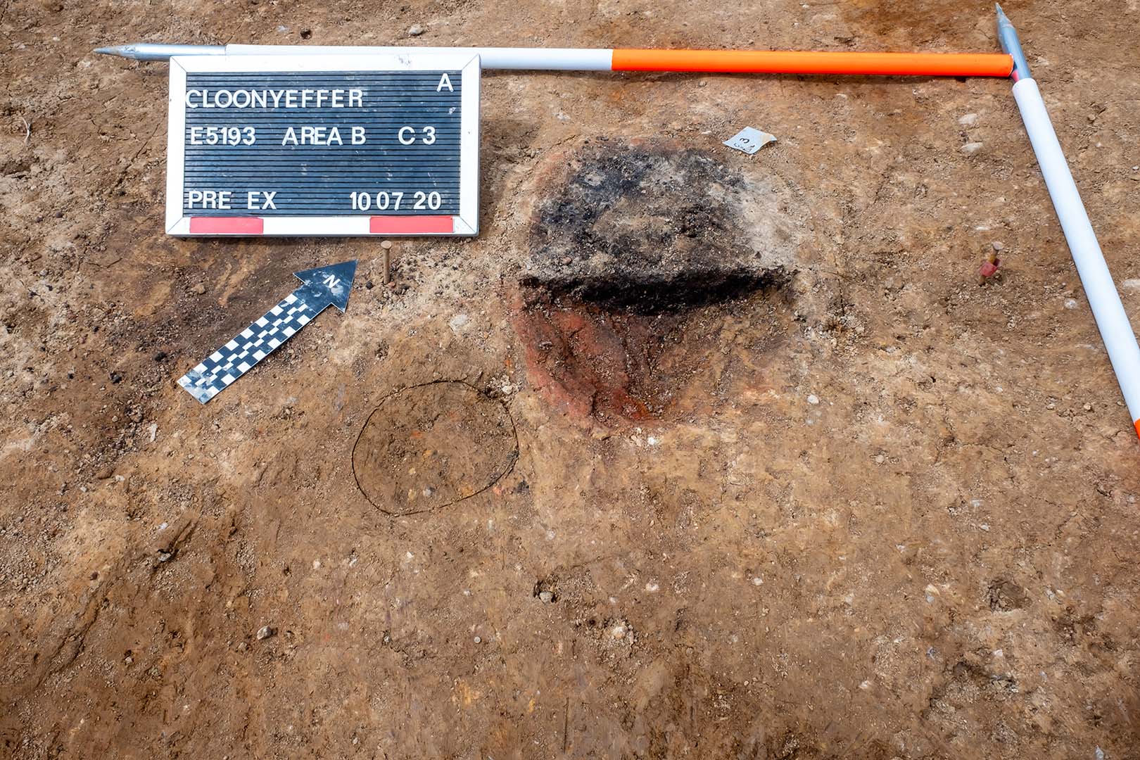
Area B comprised a pit, which was likely to have been a smelting furnace, two other pits and cultivation furrows. The furnace was sub-oval in plan, 0.39m long, 0.32m wide, 0.09m deep and contained a single fill of dark brown sandy silt, with frequent charcoal inclusions, burnt clay and occasional slag. A furrow partially truncated its upper part. One hundred pieces of slag, 40 fragments of heat-affected clay, some with smoothened surfaces, fine-grained residue containing magnetic slag fragments and droplets, hammerscale and a chert thinning flake was recovered from within this pit. Charcoal from the smithing furnace consisted exclusively of oak, with a sample of oak charcoal returning an Iron Age date of 379–179 cal. BC (UBA-47773; 2214±26BP). Of the other pits, one was sub-oval in plan, 0.75m long, 0.61m wide, 0.06m deep and contained firmly compacted mid-grey sandy silt with occasional charcoal flecks, small stones and fragments of slag and likely smithing hearth cake fragments. Charcoal from this pit consisted primarily of oak, but with ash, birch, hazel and pomaceous fruitwood also recorded. The final pit was sub-oval in plan, 1.03m long, 0.87m wide, 0.15m deep and contained firmly compacted mid-brown sandy silt with occasional charcoal flecks, small stones and fragments of slag. Two chert flakes were also recovered from this pit.
References
Hardy, C. 2021. N5 Ballaghaderreen to Scramoge Road Project Stage (i)a, (i)b, (i)c Test Excavation, Stage (i)m Testing in Felled Forestry and Stage (i)f Townland Boundary Survey. Ministerial Direction No. A077, Registration No. E5070. Unpublished AMS report for TII and RCC.
Roughan & O’Donovan-AECOM. 2017. N5 Ballaghaderreen to Scramoge Road Project Environmental Impact Assessment Report. TII and Roscommon National Road Design Office. Available at: http://www.roscommoncoco.ie/en/Services/Roads/Publications-and-Information/N5-Ballaghaderreen-to-Scramoge-Road-Project/Environmental-Impact-Assessment-Report/Volume-2B-EIAR-Chapter-11-19/00-EIAR.pdf