2020:769 - CLOONYEFFER (4), Roscommon
County: Roscommon
Site name: CLOONYEFFER (4)
Sites and Monuments Record No.: N/A
Licence number: Registration No. E5195, Ministerial Direction No. A077
Author: John Channing, c/o Archaeological Management Solutions Ltd.
Author/Organisation Address: Fahy’s Road, Kilrush, Co. Clare
Site type: House - vernacular house
Period/Dating: Modern (AD 1750-AD 2000)
ITM: E 581973m, N 787556m
Latitude, Longitude (decimal degrees): 53.837182, -8.273886
Cloonyeffer 4 was excavated in advance of construction of the N5 Ballaghaderreen to Scramoge Road Project in County Roscommon by Archaeological Management Solutions (AMS) for Roscommon County Council (RCC) and Transport Infrastructure Ireland (TII). The subsurface remains of a vernacular structure were identified during Stage (i)a Standard Test Excavations, carried out by AMS under Ministerial Direction (Direction No. A077, Registration No. E5070) (Hardy 2021). The site was indicated on the first-edition six-inch Ordnance Survey (OS) map (1838) but not on the 25-inch OS map (1914) and was not recorded in the Environmental Impact Assessment Report (Roughan & O’Donovan-AECOM 2017).
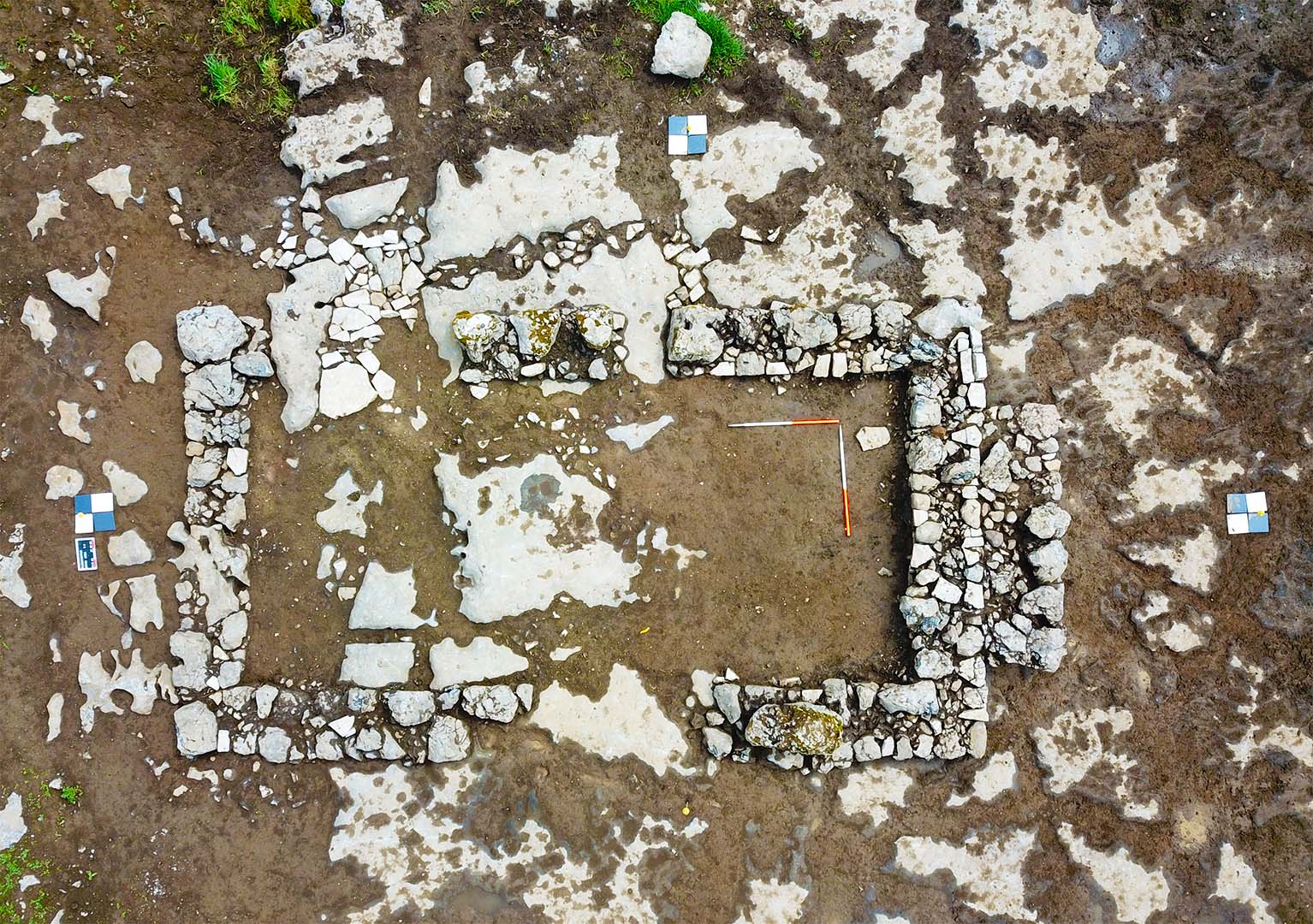
The vernacular structure was oriented north–south and measured 9.45–10m by 4.8m externally and 7.5m by 3.19m internally with two phases of construction comprising a structure and a later, supporting buttress wall. An entrance was located in the east-facing wall. No evidence for a hearth survived (Area A). A bank and ditch depicted on historical mapping were also identified (Area B).
The external walls of the structure consisted of the partial remains of four discontinuous sections of wall which overlay a partial foundation trench in the south and bedrock elsewhere. The foundation trench measured 3.5m in length (E–W) by 1.4–2.1m, 0.1–0.25m in width and 0.13m in depth. The foundation trench contained a single fill of firmly compacted dark red-brown sandy silt. The structure walls comprised a double row of unevenly coursed and roughly hewn angular and sub-angular limestone blocks, with a rubble core of firmly compacted small stones intermixed with redeposited subsoil which comprised medium grey-brown clay. The partial remains of an entrance were identified in the east-facing wall. A paved area comprised sub-angular, flat stones which were otherwise irregular in shape and size and measured 2.5m in length, c.1m in width and 0.05–0.01m in depth. The floor of the structure was level and comprised exposed/worked bedrock and trampled subsoil. A supporting buttress wall was located in the middle of the south-facing gable wall. Collapse material was found in the interior and the exterior of the structure. The bank and ditch depicted on historical mapping were identified 20.62m to the north-northwest of the structure (Area B).
According to historical records, the dwelling dates from at least the early–mid nineteenth century, although none of the individuals or families named in the records could be connected to the structure with any certainty. The site was held by James Fahy, who leased it from the representatives of William Murphy, according to Griffith’s Valuation (1857–58). The structure itself was not recorded by the Valuation, indicating it may have been under the £5 threshold. As it had disappeared by the 25-inch OS map (1914), the structure was likely knocked in the post-Famine period.
The material culture, comprising 234 artefacts, uncovered during the investigation, reflects the nineteenth-century dating of the structure. These artefacts suggest a self-sufficient farmstead with connections to both local and international trade and customs. The metal and pottery assemblage held both domestic and agricultural functions, reflecting the nature of the site. These artefacts have been analysed by specialists and a selection of these has been set aside for retention. The remainder is intended, with the approval of the NMI, for disposal.
References
Hardy, C. 2021. N5 Ballaghaderreen to Scramoge Road Project Stage (i)a, (i)b, (i)c Test Excavation, Stage (i)m Testing in Felled Forestry and Stage (i)f Townland Boundary Survey. Ministerial Direction No. A077, Registration No. E5070. Unpublished AMS report for TII and RCC.
Roughan & O’Donovan-AECOM. 2017. N5 Ballaghaderreen to Scramoge Road Project Environmental Impact Assessment Report. TII and Roscommon National Road Design Office. Available at: http://www.roscommoncoco.ie/en/Services/Roads/Publications-and-Information/N5-Ballaghaderreen-to-Scramoge-Road-Project/Environmental-Impact-Assessment-Report/Volume-2B-EIAR-Chapter-11-19/00-EIAR.pdf. [Accessed 11 November 2021].