2020:768 - CLOONYEFFER (2), Roscommon
County: Roscommon
Site name: CLOONYEFFER (2)
Sites and Monuments Record No.: N/A
Licence number: Registration No. E5194, Ministerial Direction No. A077
Author: John Channing, c/o Archaeological Management Solutions Ltd.
Author/Organisation Address: Fahy’s Road, Kilrush, Co. Clare
Site type: Burnt spread and Burial
Period/Dating: Undetermined
ITM: E 581308m, N 787534m
Latitude, Longitude (decimal degrees): 53.836961, -8.283987
Cloonyeffer 2 was excavated in advance of construction of the N5 Ballaghaderreen to Scramoge Road Project in County Roscommon by Archaeological Management Solutions (AMS) for Roscommon County Council (RCC) and Transport Infrastructure Ireland (TII). The site consisted of a burnt spread, two drains and two shallow ditches, along with an animal burial, located on marginal pasture in a gently undulating landscape. It was identified during Stage (i)m Test Excavations, carried out by AMS under Ministerial Direction (Direction No. A077, Registration No. E5070) (Hardy 2021).
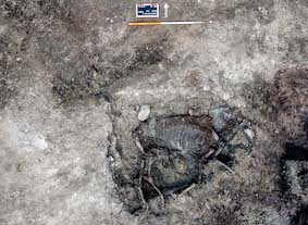
The burnt spread consisted of heat-shattered sandstone in a dark black sandy silt matrix that extended from the southern baulk measuring 7m north–south by 20m with an average depth of 0.20m. It was slightly rounded in profile, thinning to the edges and had a lower layer of burnt material consisting of a mixed reddish-brown peat with burnt spread material and root activity. A shallow pit was cut into the northern extremity of the burnt spread. The pit was sub-rectangular in plan measuring 1.1 m north–south by 1.7m by 0.4m deep with irregular gently sloping sides leading to a rounded base. A single fill contained an intact, interred, animal skeleton, which was in an anatomically correct position and is currently due for analysis and identification.
Two linear ditches occurred within the excavation area. One ran east to west and truncated part of the north edge of the burnt spread; the second ran north–south, forming a right angle with the east terminal of the first ditch. Both ditches have fills that reflect the material into which they were cut and are later than the burnt spread. Two parallel linear drains, which ran north–south, truncated both the two drains and burnt spread.
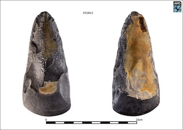
A flint scraper (E5194:1) was found in the lower fill of the burnt spread and a small stone axe with a polished bevelled edge (E5194:2) was found in topsoil during Stage (ii) cleaning back. Bulk soil samples were retrieved from the burnt spread and the fill of the pit around the rib area of the animal burial for subsequent environmental analysis. Although presently undated, the burnt spread is likely to relate to prehistoric subsistence and/or other specialised activities.
Reference
Hardy, C. 2021. N5 Ballaghaderreen to Scramoge Road Project Stage (i)a, (i)b, (i)c Test Excavation, Stage (i)m Testing in Felled Forestry and Stage (i)f Townland Boundary Survey. Ministerial Direction No. A077, Registration No. E5070. Unpublished AMS report for TII and RCC.