2020:764 - KILLEEN EAST (2), Roscommon
County: Roscommon
Site name: KILLEEN EAST (2)
Sites and Monuments Record No.: N/A
Licence number: E005099
Author: Brian O'Hara, Brigid Melloy and Kevin Kearney, AMS
Author/Organisation Address: Fahy's Road, Kilrush, Clare
Site type: Enclosure and Souterrain
Period/Dating: Early Medieval (AD 400-AD 1099)
ITM: E 588126m, N 786148m
Latitude, Longitude (decimal degrees): 53.824707, -8.180349
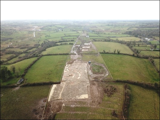
Killeen East 2 was excavated in advance of construction of the N5 Ballaghaderreen to Scramoge Road Project in County Roscommon by Archaeological Management Solutions (AMS) for Roscommon County Council (RCC) and Transport Infrastructure Ireland (TII). Killeen East 2 consisted of an early medieval enclosure and four souterrains located in a pasture field on an east–west ridge approximately 2.5km south of Elphin. The site was discovered through LiDAR (Davis 2015) and geophysical survey (Bonsall & Gimson 2016) and Stage (i)a Standard Test Excavations carried out by Archer Heritage Planning (Registration No. 16E099; O’Connell 2016). A late medieval radiocarbon date (cal. AD 1409–1444; D-AMS 019283; 495+24P) was returned on a sample taken from the upper fill of the enclosure (F5) during the archaeological testing (O’Connell 2016; Roughan & O’Donovan-AECOM 2017).
The excavation area totalled 3100m2, which includes an extension (approximately 47m x 51m) excavated to ascertain the nature and extent of an additional curving enclosure ditch. The archaeological remains consisted of a large enclosure with an adjoining annex on its western side, four stone-lined souterrains, four inhumations and numerous associated ditches, gullies and pits.
One north–south-orientated ditch which pre-dated the enclosure was identified. It was 18.35m long, 1.21m wide, 0.53m deep and was cut by the enclosure ditch and one of the souterrains. Several flint and chert flakes were recovered from the fills of the enclosure ditch, which may be residual artefacts from earlier, potentially prehistoric, activity.
Approximately 75% of the enclosure (c.46m east–west by c.31m) occurred within the CPO, with the remaining portion occurring outside its southern limit; however, the outline of this can be traced in the LiDAR and geophysical survey results. No remains of a bank existed; however, the absence of features within c.3m of the interior side of the ditch suggests an internal bank did exist. It seems that the enclosure was sub-circular, c.46m in diameter and enclosed by a c.3–4m-wide and 1.5m-deep ditch and a c.3m-wide and 1.5m-high bank. The entrance to the enclosure was through a 3.8m-wide gap in the east side and possible evidence for a small tower or gate was noted immediately inside, to the west, of the entrance. This comprised a trapezoidal arrangement of pits and post-holes approximately 2m (north–south) by 1m apart.
The rectilinear annex was entirely contained within the excavation. It was c.24m in width, and originally seems to have been entered either through a gap between the enclosure and its northern side or between the enclosure and its southern side. Its ditch was very shallow and likely truncated at these locations, so it is difficult to be sure. At some point during the occupation of the main enclosure a causeway was built across the main enclosure ditch as an access into the annex. The annex was also modified by the addition of two curvilinear ditches which flanked an entrance on its southern side.
All four souterrains were stone lined, but no stones were found in any of their fills large enough to span their roofs as lintels, so they were likely covered by timber structures. Souterrain 1 was located within the annex, just east of its centre. It was 5.15m long, 2.48m wide and 1.28m deep. The remains of two individuals were uncovered in its backfill. Souterrain 2 was located within the main enclosure’s north-western quadrant, and was 4.6m long, 3.33m wide and 0.76m deep. Souterrains 3 and 4 were located towards the centre of the main enclosure. Souterrain 3 was 4.92m long, 2.61m wide and 1.49m deep and was accessed via two phases of entrance ramps cutting the western side. Souterrain 4 was constructed following the backfill of Souterrain 3 and measured 5.3m long, 2.48m wide and 1.4m deep. The remains of a third individual were found at the base of Souterrain 4. The remains of a fourth individual were found in an isolated grave cut approximately 2.25m northeast of Souterrain 4.
In the north-eastern sector of the main enclosure, a cluster of pits with intensely oxidised edges, occasional metalworking slag, and metalworking slag from the enclosure ditch in that sector, suggests an area of metalworking production.
A total of 136 artefacts were found during the investigations, including a Neolithic axe placed behind the lining of the souterrain, and several fine personal items—notably a copper-alloy button, copper-alloy stick pins and ceramic and an amber bead—early medieval ceramics and a range of iron objects. Samples were retrieved from significant archaeological contexts for subsequent radiocarbon dating and environmental analyses.
Post-excavation analysis has commenced, and it is hoped that specialist reports, including radiocarbon dating, will further the interpretation of the site.
This preliminary report summary was submitted on behalf of its authors.
References
Bonsall, J. & Gimson, H. 2016. Geophysical Survey Report, N5 Ballaghaderreen-Scramoge Road Development. Unpublished report prepared by Earthsound Archaeological Geophysics Ltd on behalf of RCC and TII.
Davis, S. 2015. N5 Strokestown-Ballaghaderreen corridor: LiDAR Assessment. Unpublished report prepared by UCD School of Archaeology for RCC and TII.
O’Connell, A. 2016. N5 Ballaghaderreen-Scramoge Road Development, Archaeological Consultancy Services Contract, Stage (i) Services Area AH09; Killeen East, Co. Roscommon, Licence No. 16E099. Unpublished report by Archer Heritage Planning for RCC and TII.
Roughan & O’Donovan-AECOM. 2017. N5 Ballaghaderreen to Scramoge Road Project Environmental Impact Assessment Report. Roscommon: TII and Roscommon National Road Design Office. Available at: http://www.roscommoncoco.ie/en/Services/Roads/Publications-and-Information/N5-Ballaghaderreen-to-Scramoge-Road-Project/Environmental-Impact-Assessment-Report/Volume-2B-EIAR-Chapter-11-19/00-EIAR.pdf [Accessed: 31 March 2022].